TopoQuest Logo
Do you find TopoQuest useful?
Help keep TopoQuest running and adding new maps/features by donating!
Bitcoin:  19c7KJd3qBynnjoSw5npx9KScwjBe4ifkT
Litecoin:  LXs6TkuXGGXo1vDsWCkWVdjQX94eUKd6ui
Home View Maps Find Maps Find Places Resources & Links


Caulfield, Missouri Topographic Map

USGS Map Title: Caulfield, MO
USGS Map MRC: 36092E1
DRG (GeoTIFF) Download: o36092e1.tif


Neighboring USGS Topographic Map Quads:


  Cureall NW, MO  
36092F2
 

  Pottersville, MO  
36092F1
 

  South Fork, MO  
36091F8
 

  Bakersfield, MO  
36092E2
 

  Caulfield, MO  
36092E1
 

  Moody, MO  
36091E8
 

  Gamaliel, AR  
36092D2
 

  Gepp, AR  
36092D1
 

  Viola, AR  
36091D8


Map MRC Location:

N37°
W93°
N37°
W92°
H8 H7 H6 H5 H4 H3 H2 H1
G8 G7 G6 G5 G4 G3 G2 G1
F8 F7 F6 F5 F4 F3 F2 F1
E8 E7 E6 E5 E4 E3 E2 E1
D8 D7 D6 D5 D4 D3 D2 D1
C8 C7 C6 C5 C4 C3 C2 C1
B8 B7 B6 B5 B4 B3 B2 B1
A8 A7 A6 A5 A4 A3 A2 A1
N36°
W93°
N36°
W92°

Caulfield, MO USGS 1:24K Topographic Map Preview:
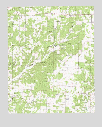
Caulfield, MO USGS Topographic Map
Click on map above to begin viewing in our Map Viewer.

This topographic map contains these locations and features:
Feature Name Type Latitude Longitude GNIS ID View Map
Alice MineMineN36.5931°W92.1221°713205View Map
AmyPopulated PlaceN36.6056°W92.0038°713270View Map
ArdittaPopulated PlaceN36.6165°W92.0627°713376View Map
Big SpringSpringN36.5776°W92.0552°714214View Map
Big Spring CemeteryCemeteryN36.5784°W92.0613°714222View Map
Big Spring ChurchChurchN36.5792°W92.0540°714223View Map
Big Spring SchoolLocaleN36.5792°W92.0518°742343View Map
Bly (historical)LocaleN36.5726°W92.0585°740325View Map
Bly Post OfficePost OfficeN36.5726°W92.0585°760027View Map
Boswell HollowValleyN36.5842°W92.0421°714549View Map
Campbell Ranch Airport (historical)AirportN36.5631°W92.0243°758993View Map
CaulfieldPopulated PlaceN36.6145°W92.1049°715508View Map
Caulfield Fire DepartmentBuildingN36.6145°W92.0895°2621550View Map
Caulfield Post OfficePost OfficeN36.6146°W92.1020°2783113View Map
Corn CreekStreamN36.5301°W92.0449°738284View Map
Crumbly HollowValleyN36.5756°W92.0574°716564View Map
Crumbly SpringSpringN36.5992°W92.0546°716565View Map
Easley BranchStreamN36.5676°W92.0679°735136View Map
Easley HollowValleyN36.5673°W92.0660°717249View Map
Egypt GrovePopulated PlaceN36.6142°W92.0310°735594View Map
Egypt Grove Church (historical)ChurchN36.6148°W92.0293°735138View Map
Egypt School (historical)SchoolN36.6151°W92.0290°735134View Map
Elm PondLakeN36.6078°W92.0677°717529View Map
Fair SpringSpringN36.6120°W92.0482°735612View Map
Fite SpringSpringN36.5956°W92.0607°717965View Map
Fowler ChurchChurchN36.6115°W92.0863°718135View Map
Free Union ChurchChurchN36.5165°W92.0379°718192View Map
Free Union SchoolSchoolN36.5165°W92.0382°742345View Map
Halsey BranchStreamN36.5490°W92.1049°719018View Map
Hamilton HollowValleyN36.5531°W92.1213°719040View Map
HocomoPopulated PlaceN36.6148°W92.0040°740933View Map
Horn CreekStreamN36.5120°W92.0132°719832View Map
Joyes CemeteryCemeteryN36.5495°W92.0418°720444View Map
Julius HollowValleyN36.5745°W92.0557°720456View Map
Lair LakeReservoirN36.6001°W92.0252°764764View Map
Lair Lake DamDamN36.6001°W92.0252°764763View Map
LeotaPopulated PlaceN36.5315°W92.0377°720917View Map
Limekiln SpringSpringN36.5595°W92.0779°721070View Map
Mashey HollowValleyN36.5670°W92.0668°721951View Map
McDaniel SpringSpringN36.6070°W92.0493°722087View Map
Mirey ForkStreamN36.5526°W92.0990°722457View Map
Nicholas SpringSpringN36.5673°W92.0371°723354View Map
Nichols SpringSpringN36.5148°W92.0913°723365View Map
Nicks CemeteryCemeteryN36.5589°W92.0143°723369View Map
Oak Grove SchoolSchoolN36.6145°W92.0904°742340View Map
Oak Mound School (historical)LocaleN36.5817°W92.0999°742341View Map
Prairie Grove ChurchChurchN36.5520°W92.0285°724849View Map
Prairie Grove SchoolLocaleN36.5534°W92.0324°742342View Map
Rattlesnake SpringSpringN36.5206°W92.1174°725121View Map
Ray BranchStreamN36.5165°W92.0121°725126View Map
Shady Grove ChurchChurchN36.5237°W92.0927°726240View Map
Shady Grove SchoolSchoolN36.5167°W92.0929°742346View Map
Smith HollowValleyN36.5406°W92.1224°726618View Map
Smith SpringSpringN36.5567°W92.1152°726632View Map
Spark SpringSpringN36.5248°W92.1079°726827View Map
Stony Point School (historical)LocaleN36.5481°W92.1010°742344View Map
Taylor HollowValleyN36.5776°W92.0535°727496View Map
Township of BentonCivilN36.5752°W92.0310°766781View Map
Union ChapelChurchN36.6040°W92.0035°735137View Map
Vaughn SpringSpringN36.6056°W92.0290°728160View Map
Wetherhill (historical)Populated PlaceN36.5820°W92.1090°740324View Map
Wildcat HollowValleyN36.5659°W92.0574°728837View Map
Youngblood CemeteryCemeteryN36.6117°W92.0865°735135View Map

Note: Coordinates in the location and feature list above are referenced to NAD83 datum.


Copyright (C) 2008-2024 Ryan Niemi / Sunset Dynamics ... All Rights Reserved