TopoQuest Logo
Do you find TopoQuest useful?
Help keep TopoQuest running and adding new maps/features by donating!
Bitcoin:  19c7KJd3qBynnjoSw5npx9KScwjBe4ifkT
Litecoin:  LXs6TkuXGGXo1vDsWCkWVdjQX94eUKd6ui
Home View Maps Find Maps Find Places Resources & Links


Entiat, Washington Topographic Map

USGS Map Title: Entiat, WA
USGS Map MRC: 47120F2
DRG (GeoTIFF) Download: o47120f2.tif


Neighboring USGS Topographic Map Quads:


  Baldy Mountain, WA  
47120G3
 

  Winesap, WA  
47120G2
 

  Chelan, WA  
47120G1
 

  Ardenvoir, WA  
47120F3
 

  Entiat, WA  
47120F2
 

  Waterville, WA  
47120F1
 

  Rocky Reach Dam, WA  
47120E3
 

  Orondo, WA  
47120E2
 

  Douglas, WA  
47120E1


Map MRC Location:

N48°
W121°
N48°
W120°
H8 H7 H6 H5 H4 H3 H2 H1
G8 G7 G6 G5 G4 G3 G2 G1
F8 F7 F6 F5 F4 F3 F2 F1
E8 E7 E6 E5 E4 E3 E2 E1
D8 D7 D6 D5 D4 D3 D2 D1
C8 C7 C6 C5 C4 C3 C2 C1
B8 B7 B6 B5 B4 B3 B2 B1
A8 A7 A6 A5 A4 A3 A2 A1
N47°
W121°
N47°
W120°

Entiat, WA USGS 1:24K Topographic Map Preview:
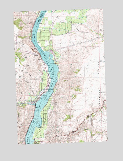
Entiat, WA USGS Topographic Map
Click on map above to begin viewing in our Map Viewer.

This topographic map contains these locations and features:
Feature Name Type Latitude Longitude GNIS ID View Map
Brays Landing CemeteryCemeteryN47.7365°W120.1690°1516925View Map
Browns CanyonValleyN47.7429°W120.1887°1516990View Map
Byrd CanyonValleyN47.7474°W120.2165°1517177View Map
Carpender SpringsSpringN47.6345°W120.1761°1517415View Map
Chelan County Fire District 8BuildingN47.6637°W120.2310°2643537View Map
City of EntiatCivilN47.6781°W120.2170°2410447View Map
Corbaley CanyonValleyN47.6274°W120.2131°1518104View Map
Coyote SpringSpringN47.7069°W120.2376°1518255View Map
Earthquake PointCliffN47.7085°W120.2170°1519070View Map
EntiatPopulated PlaceN47.6760°W120.2084°1519355View Map
Entiat (historical)Populated PlaceN47.6629°W120.2237°1530588View Map
Entiat DitchCanalN47.6662°W120.2312°1519357View Map
Entiat Federated ChurchChurchN47.6755°W120.2099°2609466View Map
Entiat Junior Senior High SchoolSchoolN47.6644°W120.2259°1530716View Map
Entiat Post OfficePost OfficeN47.6765°W120.2097°2781706View Map
Entiat Ranger StationLocaleN47.6749°W120.2106°1529688View Map
Entiat RiverStreamN47.6612°W120.2245°1519362View Map
Entiat Sewage Treatment PlantLocaleN47.6755°W120.2067°2610668View Map
Entiat ValleyValleyN47.6612°W120.2248°1519363View Map
Entiat Warehouse Community ChurchChurchN47.6908°W120.2078°2608667View Map
Friends ChurchChurchN47.6632°W120.2294°2609467View Map
Indian SpringSpringN47.6885°W120.2464°1521198View Map
Long SpringSpringN47.6995°W120.2360°1522409View Map
McKinstry CanyonValleyN47.7324°W120.2270°1522920View Map
McLeish CanyonValleyN47.6640°W120.2448°1522923View Map
OrondoPopulated PlaceN47.6260°W120.2254°1524075View Map
Orondo Community CemeteryCemeteryN47.6485°W120.2138°1524076View Map
Orondo Elementary SchoolSchoolN47.6410°W120.2165°1531055View Map
Orondo Post OfficePost OfficeN47.6252°W120.2273°2769256View Map
Paul Rumburg Elementary SchoolSchoolN47.6648°W120.2252°1530717View Map
Pine CanyonValleyN47.6365°W120.1662°1524435View Map
Ribbon CliffCliffN47.7124°W120.2242°1525022View Map
Ribbon MesaSummitN47.7193°W120.2412°1525023View Map
Silicosaska ParkParkN47.6676°W120.2179°1525745View Map
Spencer CanyonValleyN47.6282°W120.2426°1526346View Map
Will Risk Memorial ParkParkN47.6707°W120.2142°1528157View Map
Willow SpringSpringN47.6927°W120.2376°1528192View Map

Note: Coordinates in the location and feature list above are referenced to NAD83 datum.


Copyright (C) 2008-2024 Ryan Niemi / Sunset Dynamics ... All Rights Reserved