TopoQuest Logo
Do you find TopoQuest useful?
Help keep TopoQuest running and adding new maps/features by donating!
Bitcoin:  19c7KJd3qBynnjoSw5npx9KScwjBe4ifkT
Litecoin:  LXs6TkuXGGXo1vDsWCkWVdjQX94eUKd6ui
Home View Maps Find Maps Find Places Resources & Links


Donegal, Pennsylvania Topographic Map

USGS Map Title: Donegal, PA
USGS Map MRC: 40079A4
DRG (GeoTIFF) Download: o40079a4.tif


Neighboring USGS Topographic Map Quads:


  Mount Pleasant, PA  
40079B5
 

  Mammoth, PA  
40079B4
 

  Stahlstown, PA  
40079B3
 

  Connellsville, PA  
40079A5
 

  Donegal, PA  
40079A4
 

  Seven Springs, PA  
40079A3
 

  South Connellsville, PA  
39079H5
 

  Mill Run, PA  
39079H4
 

  Kingwood, PA  
39079H3


Map MRC Location:

N41°
W80°
N41°
W79°
H8 H7 H6 H5 H4 H3 H2 H1
G8 G7 G6 G5 G4 G3 G2 G1
F8 F7 F6 F5 F4 F3 F2 F1
E8 E7 E6 E5 E4 E3 E2 E1
D8 D7 D6 D5 D4 D3 D2 D1
C8 C7 C6 C5 C4 C3 C2 C1
B8 B7 B6 B5 B4 B3 B2 B1
A8 A7 A6 A5 A4 A3 A2 A1
N40°
W80°
N40°
W79°

Donegal, PA USGS 1:24K Topographic Map Preview:
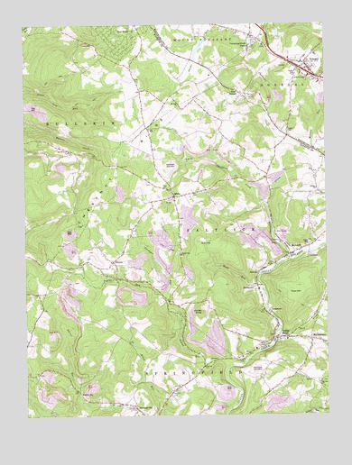
Donegal, PA USGS Topographic Map
Click on map above to begin viewing in our Map Viewer.

This topographic map contains these locations and features:
Feature Name Type Latitude Longitude GNIS ID View Map
Back CreekStreamN40.0276°W79.3945°1168559View Map
Bear Rock School (historical)SchoolN40.1009°W79.4431°1205497View Map
Bear RocksPopulated PlaceN40.1229°W79.4617°1168911View Map
Borough of DonegalCivilN40.1120°W79.3808°1215697View Map
Brown CemeteryCemeteryN40.1017°W79.4061°1170361View Map
Bullskin Township Volunteer Fire Department Station 3 - 45BuildingN40.1241°W79.4530°2645748View Map
Calvary ChurchChurchN40.0726°W79.3781°1170927View Map
Champion CreekStreamN40.0498°W79.3898°1171547View Map
ClintonPopulated PlaceN40.0492°W79.4631°1172011View Map
CoffmanPopulated PlaceN40.0517°W79.3820°1203302View Map
Cummingswood ParkPopulated PlaceN40.1215°W79.4045°1198276View Map
DavistownPopulated PlaceN40.0415°W79.4034°1172996View Map
DonegalPopulated PlaceN40.1126°W79.3825°1173368View Map
Donegal Post OfficePost OfficeN40.1104°W79.3804°2772669View Map
Fairview SchoolSchoolN40.0301°W79.4731°1205500View Map
Fowl HillSummitN40.0415°W79.3870°1175079View Map
FrogtownLocaleN40.0284°W79.3970°1205291View Map
Gerry School (historical)SchoolN40.0640°W79.4856°1205499View Map
Indian HeadPopulated PlaceN40.0248°W79.3950°1177753View Map
Indian Head Post OfficePost OfficeN40.0247°W79.3917°2772761View Map
InterchangeCrossingN40.1081°W79.3814°1177821View Map
Jockey KnobSummitN40.0334°W79.4267°1178093View Map
Lake DonegalReservoirN40.1019°W79.4127°1173373View Map
Little Champion CreekStreamN40.0679°W79.3992°1179499View Map
MelcroftPopulated PlaceN40.0520°W79.3892°1180877View Map
Melcroft Post OfficePost OfficeN40.0516°W79.3888°2772824View Map
MillertownPopulated PlaceN40.0245°W79.3814°1181263View Map
Minnow RunStreamN40.0820°W79.3800°1181348View Map
Mount Salem ChurchChurchN40.0848°W79.4811°1181847View Map
Mount Zion ChurchChurchN40.0995°W79.4356°1209228View Map
Mount Zion ChurchChurchN40.0104°W79.3775°1181913View Map
Newmyer RunStreamN40.0367°W79.4411°1182404View Map
Normalville Post OfficePost OfficeN40.0016°W79.4535°2772883View Map
Poplar RunStreamN40.0156°W79.4150°1184258View Map
Poplar Run ChurchChurchN40.0515°W79.4348°1193150View Map
Pritts SchoolSchoolN40.0101°W79.3931°1205290View Map
Rasler RunPopulated PlaceN40.0076°W79.4775°1205076View Map
RomneyPopulated PlaceN40.0456°W79.4025°1204539View Map
SagamorePopulated PlaceN40.0326°W79.3978°1185716View Map
Salt LickLocaleN40.0101°W79.4120°1205501View Map
Saltlick Township Volunteer Fire Department Station 46BuildingN40.0250°W79.3959°2645764View Map
South Spruce RunStreamN40.0634°W79.4864°1202612View Map
Stauffer SchoolSchoolN40.0834°W79.4814°1205498View Map
Sun HillSummitN40.0556°W79.4278°1189059View Map
Township of SaltlickCivilN40.0495°W79.3926°1216443View Map
Wash RunStreamN40.0423°W79.4028°1190617View Map
WhitePopulated PlaceN40.0701°W79.4370°1191246View Map
White Post OfficePost OfficeN40.0700°W79.4361°2773286View Map

Note: Coordinates in the location and feature list above are referenced to NAD83 datum.


Copyright (C) 2008-2024 Ryan Niemi / Sunset Dynamics ... All Rights Reserved