TopoQuest Logo
Do you find TopoQuest useful?
Help keep TopoQuest running and adding new maps/features by donating!
Bitcoin:  19c7KJd3qBynnjoSw5npx9KScwjBe4ifkT
Litecoin:  LXs6TkuXGGXo1vDsWCkWVdjQX94eUKd6ui
Home View Maps Find Maps Find Places Resources & Links


Cotton, Georgia Topographic Map

USGS Map Title: Cotton, GA
USGS Map MRC: 31084B1
DRG (GeoTIFF) Download: o31084b1.tif


Neighboring USGS Topographic Map Quads:


  Baconton South, GA  
31084C2
 

  Sale City, GA  
31084C1
 

  Doerun, GA  
31083C8
 

  Camilla, GA  
31084B2
 

  Cotton, GA  
31084B1
 

  Hartsfield, GA  
31083B8
 

  Pelham, GA  
31084A2
 

  Meigs, GA  
31084A1
 

  Chastain, GA  
31083A8


Map MRC Location:

N32°
W85°
N32°
W84°
H8 H7 H6 H5 H4 H3 H2 H1
G8 G7 G6 G5 G4 G3 G2 G1
F8 F7 F6 F5 F4 F3 F2 F1
E8 E7 E6 E5 E4 E3 E2 E1
D8 D7 D6 D5 D4 D3 D2 D1
C8 C7 C6 C5 C4 C3 C2 C1
B8 B7 B6 B5 B4 B3 B2 B1
A8 A7 A6 A5 A4 A3 A2 A1
N31°
W85°
N31°
W84°

Cotton, GA USGS 1:24K Topographic Map Preview:
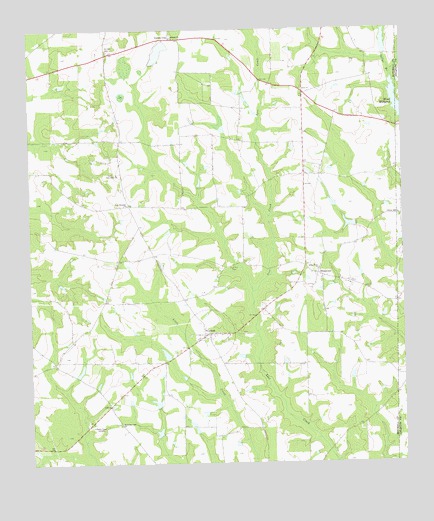
Cotton, GA USGS Topographic Map
Click on map above to begin viewing in our Map Viewer.

This topographic map contains these locations and features:
Feature Name Type Latitude Longitude GNIS ID View Map
Akridge (historical)Populated PlaceN31.2257°W84.0221°343614View Map
Akridge CemeteryCemeteryN31.2441°W84.0980°310421View Map
Antioch ChurchChurchN31.2480°W84.0763°354329View Map
Arno ChurchChurchN31.2330°W84.0332°343615View Map
Blooming Light ChurchChurchN31.1363°W84.0949°311532View Map
Connell LakeReservoirN31.2460°W84.0056°341824View Map
Connell Lake DamDamN31.2418°W84.0049°341823View Map
CottonPopulated PlaceN31.1616°W84.0668°355328View Map
Cotton Volunteer Fire DepartmentBuildingN31.1629°W84.0649°2604203View Map
Hand LakeReservoirN31.1345°W84.1248°342048View Map
Hand Lake DamDamN31.1352°W84.1249°342047View Map
HinsontonPopulated PlaceN31.1796°W84.0285°331994View Map
Lake Pleasant ChurchChurchN31.1999°W84.0921°316542View Map
LaneyPopulated PlaceN31.2085°W84.0266°325834View Map
Liberty Hill CemeteryCemeteryN31.1960°W84.0016°343979View Map
Liberty Hill ChurchChurchN31.1960°W84.0002°316832View Map
Mims MillpondLakeN31.2287°W84.0011°318308View Map
New Hope ChurchChurchN31.2088°W84.0955°319368View Map
Pebble CityPopulated PlaceN31.2477°W84.0777°332627View Map
Pebble City ChurchChurchN31.2477°W84.0771°343653View Map
Rigsby LakeReservoirN31.2425°W84.1051°340877View Map
Rigsby LakeReservoirN31.2436°W84.0811°341826View Map
Rigsby Lake DamDamN31.2435°W84.1066°340876View Map
Rigsby Lake DamDamN31.2402°W84.0832°341825View Map
RogervillePopulated PlaceN31.1605°W84.1113°343661View Map
Saco (historical)Populated PlaceN31.1852°W84.0835°343662View Map
Sallys BranchStreamN31.2416°W84.0041°322377View Map
Sonny Glenn Estate LakeReservoirN31.1939°W84.0180°341822View Map
Sonny Glenn Estate Lake DamDamN31.1935°W84.0149°341821View Map
Turner School (historical)SchoolN31.2330°W84.0335°343668View Map
WABW-TV (Pelham)TowerN31.1349°W84.1043°352861View Map
White Rock ChurchChurchN31.1813°W84.0282°325191View Map
Willingham LakeReservoirN31.1936°W84.1086°341820View Map
Willingham Lake DamDamN31.1935°W84.1116°341819View Map
Zion Hill CemeteryCemeteryN31.1821°W84.0568°325687View Map
Zion Hill ChurchChurchN31.1819°W84.0568°343671View Map

Note: Coordinates in the location and feature list above are referenced to NAD83 datum.


Copyright (C) 2008-2024 Ryan Niemi / Sunset Dynamics ... All Rights Reserved