TopoQuest Logo
Do you find TopoQuest useful?
Help keep TopoQuest running and adding new maps/features by donating!
Bitcoin:  19c7KJd3qBynnjoSw5npx9KScwjBe4ifkT
Litecoin:  LXs6TkuXGGXo1vDsWCkWVdjQX94eUKd6ui
Home View Maps Find Maps Find Places Resources & Links


Meigs, Georgia Topographic Map

USGS Map Title: Meigs, GA
USGS Map MRC: 31084A1
DRG (GeoTIFF) Download: o31084a1.tif


Neighboring USGS Topographic Map Quads:


  Camilla, GA  
31084B2
 

  Cotton, GA  
31084B1
 

  Hartsfield, GA  
31083B8
 

  Pelham, GA  
31084A2
 

  Meigs, GA  
31084A1
 

  Chastain, GA  
31083A8
 

  Cairo North, GA  
30084H2
 

  Ochlocknee, GA  
30084H1
 

  Merrillville, GA  
30083H8


Map MRC Location:

N32°
W85°
N32°
W84°
H8 H7 H6 H5 H4 H3 H2 H1
G8 G7 G6 G5 G4 G3 G2 G1
F8 F7 F6 F5 F4 F3 F2 F1
E8 E7 E6 E5 E4 E3 E2 E1
D8 D7 D6 D5 D4 D3 D2 D1
C8 C7 C6 C5 C4 C3 C2 C1
B8 B7 B6 B5 B4 B3 B2 B1
A8 A7 A6 A5 A4 A3 A2 A1
N31°
W85°
N31°
W84°

Meigs, GA USGS 1:24K Topographic Map Preview:
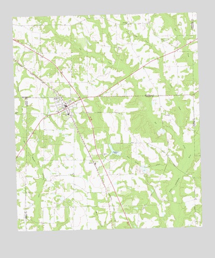
Meigs, GA USGS Topographic Map
Click on map above to begin viewing in our Map Viewer.

This topographic map contains these locations and features:
Feature Name Type Latitude Longitude GNIS ID View Map
Big CreekStreamN31.0288°W84.0135°354711View Map
Brumbly BridgeBridgeN31.0049°W84.1116°343695View Map
Center Hill School (historical)SchoolN31.0255°W84.0655°343698View Map
City of MeigsCivilN31.0714°W84.0922°2405064View Map
HansellPopulated PlaceN31.0280°W84.0668°343739View Map
Harmony ChurchChurchN31.1196°W84.0468°315138View Map
Little CreekStreamN31.0510°W84.0149°317019View Map
MeigsPopulated PlaceN31.0724°W84.0891°318004View Map
Meigs Baptist ChurchChurchN31.0741°W84.0902°343759View Map
Meigs DivisionCivilN31.0460°W84.0637°1936401View Map
Meigs Methodist ChurchChurchN31.0713°W84.0888°343760View Map
Meigs Police DeptBuildingN31.0720°W84.0908°2733689View Map
Meigs Post OfficePost OfficeN31.0719°W84.0903°352169View Map
Meigs Volunteer Fire Department Station 9BuildingN31.0730°W84.0907°2603930View Map
Midway CemeteryCemeteryN31.0441°W84.0660°343764View Map
Midway ChurchChurchN31.0438°W84.0655°318106View Map
Oaky Woods CreekStreamN31.0321°W84.0138°319877View Map
Palmer BridgeBridgeN31.0313°W84.0107°343784View Map
Pilcher CreekStreamN31.0607°W84.1216°320518View Map
Pine Hill School (historical)SchoolN31.0385°W84.1235°342517View Map
Providence CemeteryCemeteryN31.0663°W84.0210°343798View Map
Providence ChurchChurchN31.0660°W84.0202°321186View Map
QualityPopulated PlaceN31.0407°W84.0735°332770View Map
Ravenwood SchoolSchoolN31.0674°W84.0888°321327View Map
Roup BridgeBridgeN31.0155°W84.0196°343806View Map
Saint Beulah Primitive Baptist ChurchChurchN31.0666°W84.0849°343808View Map
Segler Mill BridgeBridgeN31.0299°W84.1071°343821View Map
Sevell LakeReservoirN31.0187°W84.0943°342088View Map
Sevell Lake DamDamN31.0202°W84.0949°342087View Map
Singletary LakeReservoirN31.1085°W84.0730°342203View Map
Singletary Lake DamDamN31.1069°W84.0732°342202View Map
Singletary PondReservoirN31.0441°W84.0535°323031View Map
Singletary Pond DamDamN31.0441°W84.0535°342089View Map
Sunset CemeteryCemeteryN31.0727°W84.0988°323770View Map
White CemeteryCemeteryN31.0163°W84.0985°343855View Map

Note: Coordinates in the location and feature list above are referenced to NAD83 datum.


Copyright (C) 2008-2024 Ryan Niemi / Sunset Dynamics ... All Rights Reserved