TopoQuest Logo
Do you find TopoQuest useful?
Help keep TopoQuest running and adding new maps/features by donating!
Bitcoin:  19c7KJd3qBynnjoSw5npx9KScwjBe4ifkT
Litecoin:  LXs6TkuXGGXo1vDsWCkWVdjQX94eUKd6ui
Home View Maps Find Maps Find Places Resources & Links


Colorado National Monument, Colorado Topographic Map

USGS Map Title: Colorado National Monument, CO
USGS Map MRC: 39108A6
DRG (GeoTIFF) Download: o39108a6.tif


Neighboring USGS Topographic Map Quads:


  Mack, CO  
39108B7
 

  Fruita, CO  
39108B6
 

  Corcoran Point, CO  
39108B5
 

  Battleship Rock, CO  
39108A7
 

  Colorado National Monument, CO  
39108A6
 

  Grand Junction, CO  
39108A5
 

  Payne Wash, CO  
38108H7
 

  Glade Park, CO  
38108H6
 

  Island Mesa, CO  
38108H5


Map MRC Location:

N40°
W109°
N40°
W108°
H8 H7 H6 H5 H4 H3 H2 H1
G8 G7 G6 G5 G4 G3 G2 G1
F8 F7 F6 F5 F4 F3 F2 F1
E8 E7 E6 E5 E4 E3 E2 E1
D8 D7 D6 D5 D4 D3 D2 D1
C8 C7 C6 C5 C4 C3 C2 C1
B8 B7 B6 B5 B4 B3 B2 B1
A8 A7 A6 A5 A4 A3 A2 A1
N39°
W109°
N39°
W108°

Colorado National Monument, CO USGS 1:24K Topographic Map Preview:
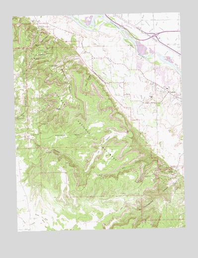
Colorado National Monument, CO USGS Topographic Map
Click on map above to begin viewing in our Map Viewer.

This topographic map contains these locations and features:
Feature Name Type Latitude Longitude GNIS ID View Map
Artists PointCliffN39.0730°W108.7234°174533View Map
Balanced RockPillarN39.1078°W108.7340°196449View Map
Black RidgeRidgeN39.0653°W108.7482°202253View Map
Black Ridge TrailTrailN39.0730°W108.7382°196416View Map
Book Cliff ViewLocaleN39.1041°W108.7268°174542View Map
Broadway Elementary SchoolSchoolN39.0810°W108.6364°174548View Map
Coke OvensPillarN39.0755°W108.7223°174529View Map
Coke Ovens OverlookLocaleN39.0791°W108.7265°174532View Map
Cold Shivers PointCliffN39.0305°W108.6548°174519View Map
Colorado National MonumentParkN39.0504°W108.6921°202252View Map
Colorado National Monument HeadquartersLocaleN39.1003°W108.7351°174551View Map
Colorado River Wildlife Management AreaParkN39.0968°W108.6323°2765253View Map
Columbus CanyonValleyN39.0410°W108.6508°174525View Map
Cruse WashStreamN39.0036°W108.7384°185212View Map
Culvert ArchArchN39.0339°W108.6450°2677710View Map
Devils KitchenPillarN39.0255°W108.6318°174523View Map
Devils Kitchen Picnic AreaLocaleN39.0325°W108.6329°174522View Map
Distant View OverlookLocaleN39.1105°W108.7395°174561View Map
East Entrance Colorado National MonumentLocaleN39.0375°W108.6312°174545View Map
East Entrance Monument CanyonValleyN39.1011°W108.7001°174535View Map
Fallen Rock OverlookLocaleN39.0394°W108.7123°174566View Map
Fruita AqueductCanalN39.0919°W108.7443°174554View Map
Fruita CanyonValleyN39.1185°W108.7299°174563View Map
Fruita Canyon ViewLocaleN39.1061°W108.7401°174559View Map
Fruita ReservoirReservoirN39.1172°W108.7318°174562View Map
Fruita Settling Basin Number 2 DamDamN39.1216°W108.7357°199912View Map
Fruita Settling Basin Number 2 ReservoirReservoirN39.1219°W108.7339°199913View Map
Glade Park CemeteryCemeteryN39.0075°W108.7390°174534View Map
Gold Star CanyonValleyN39.0908°W108.6911°174538View Map
Grand Junction Carrier Annex Post OfficePost OfficeN39.1108°W108.6373°2750898View Map
Grand Junction Fire Department Station 5BuildingN39.0853°W108.6493°2667032View Map
Grand ViewLocaleN39.0903°W108.7257°174543View Map
Highland View OverlookLocaleN39.0625°W108.7284°174528View Map
Hinderlider Lift CanalCanalN39.0866°W108.6832°174553View Map
Historic Trail ViewLocaleN39.1175°W108.7390°174560View Map
Huffer PitMineN39.0947°W108.6807°1684072View Map
Hunter WashStreamN39.1180°W108.6687°174390View Map
Independence MonumentPillarN39.0958°W108.7234°174539View Map
John Ottos TrailTrailN39.0972°W108.7298°196417View Map
KEKB-FM (Fruita)TowerN39.0655°W108.7484°204133View Map
KIOB-FM (Grand Junction)TowerN39.0666°W108.7454°204145View Map
Kissing CouplePillarN39.0891°W108.7182°174530View Map
KJOL-FM (Grand Junction)TowerN39.0658°W108.7473°204142View Map
KJYE-FM (Grand Junction)TowerN39.0666°W108.7454°204146View Map
KPRN-FM (Grand Junction)TowerN39.0658°W108.7465°204141View Map
Liberty CapPillarN39.0564°W108.6701°174531View Map
Liberty Cap TrailTrailN39.0522°W108.7090°196415View Map
Limekin GulchValleyN39.0954°W108.6450°174550View Map
Lizard CanyonValleyN39.1144°W108.7207°174564View Map
Monument CanyonValleyN39.0957°W108.7135°174536View Map
Monument Canyon TrailTrailN39.0894°W108.7176°174555View Map
Monument MesaSummitN39.0469°W108.7059°174565View Map
Persigo WashStreamN39.1091°W108.6595°174388View Map
Pinyon AirportAirportN39.0029°W108.7107°204413View Map
Pipe OrganPillarN39.0989°W108.7262°174540View Map
Pritchard WashStreamN39.1108°W108.6618°174389View Map
Red Canyon OverlookLocaleN39.0300°W108.6868°174521View Map
RedlandsPopulated PlaceN39.0789°W108.6357°202254View Map
Redlands Census Designated PlaceCensusN39.0885°W108.6580°2409153View Map
Redlands First Lift CanalCanalN39.0794°W108.6479°202255View Map
Redlands Middle SchoolSchoolN39.0846°W108.6441°174547View Map
Redlands Second Lift CanalCanalN39.0791°W108.6673°174552View Map
Riggs HillSummitN39.0761°W108.6470°174549View Map
SaddlehornSummitN39.1022°W108.7329°174558View Map
Sentinel SpirePillarN39.1030°W108.7262°174541View Map
Serpents TrailTrailN39.0300°W108.6368°174546View Map
Squaw FingersPillarN39.0708°W108.7204°174527View Map
Suction PointCliffN39.0453°W108.7234°174520View Map
Thompson Ditch DrawValleyN39.0055°W108.7463°185211View Map
Ute Canal TrailTrailN39.0375°W108.7076°174518View Map
Ute CanyonValleyN39.0528°W108.6654°174516View Map
Wedding CanyonValleyN39.1124°W108.7172°174537View Map
West Entrance Colorado National MonumentLocaleN39.1186°W108.7312°174544View Map
Window RockArchN39.1056°W108.7258°174556View Map

Note: Coordinates in the location and feature list above are referenced to NAD83 datum.


Copyright (C) 2008-2024 Ryan Niemi / Sunset Dynamics ... All Rights Reserved