TopoQuest Logo
Do you find TopoQuest useful?
Help keep TopoQuest running and adding new maps/features by donating!
Bitcoin:  19c7KJd3qBynnjoSw5npx9KScwjBe4ifkT
Litecoin:  LXs6TkuXGGXo1vDsWCkWVdjQX94eUKd6ui
Home View Maps Find Maps Find Places Resources & Links


Cloverport, Kentucky Topographic Map

USGS Map Title: Cloverport, KY
USGS Map MRC: 37086G6
DRG (GeoTIFF) Download: o37086g6.tif


Neighboring USGS Topographic Map Quads:


  Tell City, IN  
37086H7
 

  Cannelton, IN  
37086H6
 

  Rome, IN  
37086H5
 

  Pellville, KY  
37086G7
 

  Cloverport, KY  
37086G6
 

  Mattingly, KY  
37086G5
 

  Whitesville, KY  
37086F7
 

  Fordsville, KY  
37086F6
 

  Glen Dean, KY  
37086F5


Map MRC Location:

N38°
W87°
N38°
W86°
H8 H7 H6 H5 H4 H3 H2 H1
G8 G7 G6 G5 G4 G3 G2 G1
F8 F7 F6 F5 F4 F3 F2 F1
E8 E7 E6 E5 E4 E3 E2 E1
D8 D7 D6 D5 D4 D3 D2 D1
C8 C7 C6 C5 C4 C3 C2 C1
B8 B7 B6 B5 B4 B3 B2 B1
A8 A7 A6 A5 A4 A3 A2 A1
N37°
W87°
N37°
W86°

Cloverport, KY USGS 1:24K Topographic Map Preview:
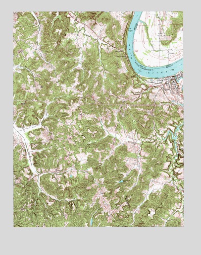
Cloverport, KY USGS Topographic Map
Click on map above to begin viewing in our Map Viewer.

This topographic map contains these locations and features:
Feature Name Type Latitude Longitude GNIS ID View Map
Arrington CornerPopulated PlaceN37.7748°W86.7486°507416View Map
Bethlehem Baptist ChurchChurchN37.7774°W86.7487°487028View Map
City of CloverportCivilN37.8312°W86.6304°2404083View Map
Clover CreekStreamN37.8384°W86.6308°489703View Map
CloverportPopulated PlaceN37.8334°W86.6328°489709View Map
Cloverport Fire DepartmentBuildingN37.8350°W86.6393°2636755View Map
Cloverport Historical MarkerParkN37.8368°W86.6364°2744074View Map
Cloverport Police DepartmentBuildingN37.8370°W86.6322°2767692View Map
DukesPopulated PlaceN37.8248°W86.6983°507885View Map
Dukes Volunteer Fire DepartmentBuildingN37.8251°W86.6982°2637049View Map
Faucett CreekStreamN37.8387°W86.6589°492003View Map
Faucett GutGutN37.8383°W86.6586°2742792View Map
Harris Memorial ChurchChurchN37.8620°W86.6417°435783View Map
Honey Locust CreekStreamN37.8017°W86.6319°494481View Map
Honey Locust LakeReservoirN37.7762°W86.6710°494482View Map
Keg BranchStreamN37.7789°W86.6333°495603View Map
Lincoln Family Historical MarkerParkN37.8371°W86.6345°2744133View Map
Little Caney CreekStreamN37.8056°W86.7472°496657View Map
Little Tar SpringsLocaleN37.8481°W86.6669°496877View Map
Midway (historical)Populated PlaceN37.8639°W86.6846°2743746View Map
Mullens RidgeRidgeN37.7645°W86.6689°499082View Map
PatesvillePopulated PlaceN37.7820°W86.7189°508779View Map
Patesville DivisionCivilN37.7683°W86.7395°1937192View Map
Pond RunStreamN37.8698°W86.6572°441430View Map
Rice CemeteryCemeteryN37.8378°W86.7478°501773View Map
Saint Rose CemeteryCemeteryN37.8139°W86.6694°502736View Map
Scuffletown (historical)Populated PlaceN37.8012°W86.7090°2743751View Map
Slick CreekStreamN37.8412°W86.6261°503679View Map
South Fork Honey Locust CreekStreamN37.7978°W86.6569°503928View Map
Sunny CornerPopulated PlaceN37.8523°W86.6697°509162View Map
Tar SpringsSpringN37.7942°W86.6258°504959View Map
Tar Springs Historical MarkerParkN37.8367°W86.6364°2744186View Map
TobinsportPopulated PlaceN37.8526°W86.6355°444792View Map
Tuckers RidgeRidgeN37.7645°W86.6400°505549View Map

Note: Coordinates in the location and feature list above are referenced to NAD83 datum.


Copyright (C) 2008-2024 Ryan Niemi / Sunset Dynamics ... All Rights Reserved