TopoQuest Logo
Do you find TopoQuest useful?
Help keep TopoQuest running and adding new maps/features by donating!
Bitcoin:  19c7KJd3qBynnjoSw5npx9KScwjBe4ifkT
Litecoin:  LXs6TkuXGGXo1vDsWCkWVdjQX94eUKd6ui
Home View Maps Find Maps Find Places Resources & Links


Anacortes North, Washington Topographic Map

USGS Map Title: Anacortes North, WA
USGS Map MRC: 48122E5
DRG (GeoTIFF) Download: o48122e5.tif


Neighboring USGS Topographic Map Quads:


  Lummi Island, WA  
48122F6
 

  Eliza Island, WA  
48122F5
 

  Bellingham South, WA  
48122F4
 

  Cypress Island, WA  
48122E6
 

  Anacortes North, WA  
48122E5
 

  Bow, WA  
48122E4
 

  Deception Pass, WA  
48122D6
 

  Anacortes South, WA  
48122D5
 

  La Conner, WA  
48122D4


Map MRC Location:

N49°
W123°
N49°
W122°
H8 H7 H6 H5 H4 H3 H2 H1
G8 G7 G6 G5 G4 G3 G2 G1
F8 F7 F6 F5 F4 F3 F2 F1
E8 E7 E6 E5 E4 E3 E2 E1
D8 D7 D6 D5 D4 D3 D2 D1
C8 C7 C6 C5 C4 C3 C2 C1
B8 B7 B6 B5 B4 B3 B2 B1
A8 A7 A6 A5 A4 A3 A2 A1
N48°
W123°
N48°
W122°

Anacortes North, WA USGS 1:24K Topographic Map Preview:
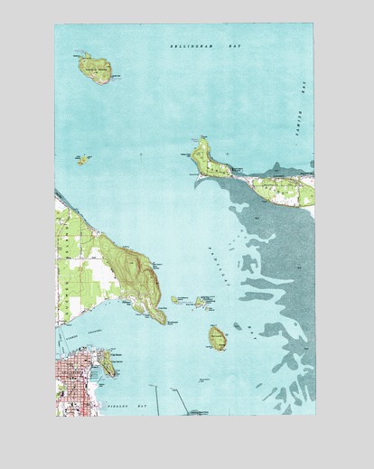
Anacortes North, WA USGS Topographic Map
Click on map above to begin viewing in our Map Viewer.

This topographic map contains these locations and features:
Feature Name Type Latitude Longitude GNIS ID View Map
AnacortesPopulated PlaceN48.5126°W122.6127°1511964View Map
Anacortes Christian ChurchChurchN48.5121°W122.6167°2609222View Map
Anacortes Christian Reformed ChurchChurchN48.5140°W122.6138°2608427View Map
Anacortes City HallBuildingN48.5177°W122.6113°2610599View Map
Anacortes Ferry LandingLocaleN48.5190°W122.6235°2608101View Map
Anacortes Fire DepartmentBuildingN48.5120°W122.6137°2606730View Map
Anacortes High SchoolSchoolN48.5071°W122.6226°1514080View Map
Anacortes History MuseumBuildingN48.5156°W122.6176°2610406View Map
Anacortes Lutheran ChurchChurchN48.5053°W122.6146°2609223View Map
Anacortes MarinaLocaleN48.5033°W122.6033°2610331View Map
Anacortes Middle SchoolSchoolN48.5036°W122.6182°1514081View Map
Anacortes Police DepartmentBuildingN48.5032°W122.6165°2606799View Map
Anacortes Post OfficePost OfficeN48.5177°W122.6120°2606909View Map
Anacortes Public LibraryBuildingN48.5147°W122.6164°2610109View Map
Anacortes School District OfficeSchoolN48.5036°W122.6182°2518394View Map
Anacortes Wastewater Treatment PlantLocaleN48.5185°W122.6073°2610643View Map
Anacortes Yacht ClubLocaleN48.5148°W122.6064°2610332View Map
Anchor Cove MarinaLocaleN48.5191°W122.6222°2610261View Map
Blue Heron BeachBeachN48.5765°W122.5049°1503450View Map
Boat HarborBayN48.5479°W122.5799°1510692View Map
Camp KirbyLocaleN48.5768°W122.5560°1503742View Map
Cap SantePopulated PlaceN48.5182°W122.6004°1510451View Map
Cap SanteCapeN48.5173°W122.5993°1503790View Map
Cap Sante MarineLocaleN48.5114°W122.6079°2610338View Map
Cap Sante ParkParkN48.5170°W122.6027°1503791View Map
Cap Sante WaterwayGutN48.5129°W122.5943°1531683View Map
Casperson PointCapeN48.5292°W122.5736°1508572View Map
Causland ParkParkN48.5165°W122.6166°1514147View Map
Chandler's Square Retirement CommunityBuildingN48.5118°W122.6153°2607771View Map
Christ Episcopal ChurchChurchN48.5170°W122.6159°2608951View Map
Cooks CoveBayN48.5326°W122.5818°1504119View Map
Deadman BayBayN48.5362°W122.5896°1504367View Map
Dot IslandIslandN48.5340°W122.5535°1504513View Map
Fidalgo Care CenterBuildingN48.5004°W122.6149°2607666View Map
Fidalgo PoolLocaleN48.5045°W122.6235°1514185View Map
Fidalgo Yacht ClubLocaleN48.5127°W122.6073°2610264View Map
GuemesPopulated PlaceN48.5301°W122.6249°1511016View Map
Guemes ChannelChannelN48.5240°W122.6227°1530916View Map
Guemes Island Community ChurchChurchN48.5348°W122.6245°2609226View Map
Guemes Island Ferry LandingLocaleN48.5282°W122.6246°2608102View Map
Hat IslandIslandN48.5240°W122.5479°1505413View Map
Huckleberry IslandIslandN48.5368°W122.5688°1505645View Map
Island HospitalHospitalN48.5019°W122.6157°2607647View Map
Island Hospital Emergency ServicesBuildingN48.5020°W122.6163°2643617View Map
Island View Elementary SchoolSchoolN48.5017°W122.6212°1534588View Map
Jack IslandIslandN48.5812°W122.6124°1505772View Map
Levant PassageChannelN48.5448°W122.5632°1514720View Map
Long BayBayN48.5343°W122.5768°1506274View Map
March Point LightLocaleN48.5107°W122.5574°1506464View Map
Padilla BayBayN48.5226°W122.5291°1524138View Map
Penguin HarborChannelN48.5623°W122.5713°1514936View Map
Port of AnacortesLocaleN48.5220°W122.6124°1514376View Map
Port of Anacortes MarinaLocaleN48.5128°W122.6055°2610364View Map
Rosario Assisted Living FacilityBuildingN48.5008°W122.6147°2607667View Map
Saddlebag IslandIslandN48.5359°W122.5563°1507988View Map
Saddlebag Island State ParkParkN48.5359°W122.5563°1507989View Map
Samish BayBayN48.6057°W122.5168°1525399View Map
Samish BeachBeachN48.5754°W122.5185°1508070View Map
Samish IslandPopulated PlaceN48.5759°W122.5410°1512638View Map
Samish IslandIslandN48.5737°W122.5299°1525400View Map
San Juan Rehabilitation and Care CenterBuildingN48.5050°W122.6118°2607906View Map
Secret Harbor SchoolSchoolN48.5079°W122.6124°2518409View Map
Skagit County Fire District 5 Samish IslandBuildingN48.5731°W122.5229°2643662View Map
The Fidalgo CenterBuildingN48.5032°W122.6237°2608288View Map
The Island Hospital HeliportAirportN48.5026°W122.6149°1533663View Map
Thriftmart Shopping CenterLocaleN48.5098°W122.6118°1513780View Map
United Methodist Church of AnacortesChurchN48.5041°W122.6245°2609234View Map
Vendovi IslandIslandN48.6107°W122.6049°1509217View Map
W T Preston Snagboat Heritage CenterBuildingN48.5164°W122.6088°2610407View Map
Westminster Presbyterian ChurchChurchN48.5154°W122.6176°2609235View Map
Whitney Elementary SchoolSchoolN48.5121°W122.6178°1531188View Map
William PointCapeN48.5871°W122.5563°1509531View Map

Note: Coordinates in the location and feature list above are referenced to NAD83 datum.


Copyright (C) 2008-2024 Ryan Niemi / Sunset Dynamics ... All Rights Reserved