TopoQuest Logo
Do you find TopoQuest useful?
Help keep TopoQuest running and adding new maps/features by donating!
Bitcoin:  19c7KJd3qBynnjoSw5npx9KScwjBe4ifkT
Litecoin:  LXs6TkuXGGXo1vDsWCkWVdjQX94eUKd6ui
Home View Maps Find Maps Find Places Resources & Links


Clarksburg, Tennessee Topographic Map

USGS Map Title: Clarksburg, TN
USGS Map MRC: 35088G4
DRG (GeoTIFF) Download: o35088g4.tif


Neighboring USGS Topographic Map Quads:


  McLemoresville, TN  
35088H5
 

  Palmer Shelter, TN  
35088H4
 

  Buena Vista, TN  
35088H3
 

  Cedar Grove, TN  
35088G5
 

  Clarksburg, TN  
35088G4
 

  Yuma, TN  
35088G3
 

  Juno, TN  
35088F5
 

  Lexington, TN  
35088F4
 

  Chesterfield, TN  
35088F3


Map MRC Location:

N36°
W89°
N36°
W88°
H8 H7 H6 H5 H4 H3 H2 H1
G8 G7 G6 G5 G4 G3 G2 G1
F8 F7 F6 F5 F4 F3 F2 F1
E8 E7 E6 E5 E4 E3 E2 E1
D8 D7 D6 D5 D4 D3 D2 D1
C8 C7 C6 C5 C4 C3 C2 C1
B8 B7 B6 B5 B4 B3 B2 B1
A8 A7 A6 A5 A4 A3 A2 A1
N35°
W89°
N35°
W88°

Clarksburg, TN USGS 1:24K Topographic Map Preview:
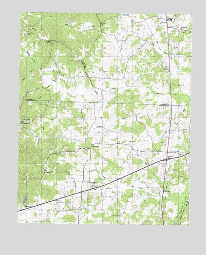
Clarksburg, TN USGS Topographic Map
Click on map above to begin viewing in our Map Viewer.

This topographic map contains these locations and features:
Feature Name Type Latitude Longitude GNIS ID View Map
Bardwell BranchStreamN35.8356°W88.4762°1276288View Map
Beaver Elementary SchoolSchoolN35.7701°W88.3934°1648231View Map
Bible HillLocaleN35.8212°W88.4778°1317445View Map
Bible Hill ChurchChurchN35.8190°W88.4809°1277213View Map
Big Beaver CreekStreamN35.7653°W88.3778°1277227View Map
Big Spring Church (historical)ChurchN35.8190°W88.4450°1317446View Map
Buggy BranchStreamN35.8476°W88.4906°1275386View Map
Carnell CemeteryCemeteryN35.8067°W88.3770°1279685View Map
Carroll County Rural Fire Department District 4 ClarksburgBuildingN35.8715°W88.3920°2654154View Map
Cat CreekStreamN35.8406°W88.4834°1279867View Map
Center Ridge School (historical)SchoolN35.8478°W88.4595°1320318View Map
City of Parker's CrossroadsCivilN35.7895°W88.3903°2404480View Map
ClarksburgPopulated PlaceN35.8717°W88.3931°1305942View Map
Clarksburg High SchoolSchoolN35.8717°W88.3900°1320320View Map
Clarksburg Missionary Baptist ChurchChurchN35.8706°W88.3970°1646033View Map
Clarksburg Post OfficePost OfficeN35.8722°W88.3937°1651407View Map
Coffman CemeteryCemeteryN35.8139°W88.4531°1317461View Map
Commissioner District 1CivilN35.7727°W88.4612°2464244View Map
District 13 (historical)CivilN35.8584°W88.3917°1325886View Map
District 7 (historical)CivilN35.8640°W88.4501°1325880View Map
Donald Halters DamDamN35.8667°W88.4484°1302185View Map
Donald Halters LakeReservoirN35.8667°W88.4484°1302184View Map
Douglass CemeteryCemeteryN35.7576°W88.4706°1282745View Map
Elon Douglas DamDamN35.7751°W88.4450°1302130View Map
Elon Douglas LakeReservoirN35.7744°W88.4448°1302129View Map
Flake CemeteryCemeteryN35.7642°W88.4198°1284360View Map
Floyville (historical)Populated PlaceN35.8001°W88.4500°1310811View Map
Hart CemeteryCemeteryN35.8192°W88.4753°1287040View Map
Hart SchoolSchoolN35.8281°W88.4934°1287049View Map
Henderson County Fire Department Station 3BuildingN35.7819°W88.3923°2654234View Map
Hickory Plains ChurchChurchN35.8631°W88.4948°1306567View Map
Interchange 108CrossingN35.7895°W88.3917°1310814View Map
Jones CemeteryCemeteryN35.7937°W88.3803°1289729View Map
JumboPopulated PlaceN35.8665°W88.4906°1289880View Map
Lewis CemeteryCemeteryN35.7528°W88.4056°1291070View Map
Little Beaver CreekStreamN35.7656°W88.3834°1291374View Map
Marlin CemeteryCemeteryN35.7792°W88.3798°1292705View Map
Mount Ararat ChurchChurchN35.8206°W88.4798°1294548View Map
Mount Ararat SpringSpringN35.7633°W88.3940°1310818View Map
Mount Pleasant ChurchChurchN35.8092°W88.4978°1294766View Map
North Fork Big Beaver CreekStreamN35.7726°W88.4264°1295860View Map
North Fork Mud CreekStreamN35.8320°W88.4095°1295904View Map
Palestine CemeteryCemeteryN35.8576°W88.4784°1326674View Map
Palestine ChurchChurchN35.8578°W88.4787°1296682View Map
Park Meals SchoolSchoolN35.7834°W88.4814°1296787View Map
Parker Chapel (historical)ChurchN35.8381°W88.4053°1320359View Map
Parker CrossroadsPopulated PlaceN35.7937°W88.3909°1652486View Map
Parker Crossroads School (historical)SchoolN35.8001°W88.3900°1317501View Map
Parkers Chapel SchoolSchoolN35.8603°W88.3923°1296838View Map
Pearson CemeteryCemeteryN35.7992°W88.4192°1297077View Map
Pigham CreekStreamN35.8276°W88.3978°1297454View Map
Poplar Corner ChurchChurchN35.7748°W88.4478°1298175View Map
Pritchard SchoolSchoolN35.8065°W88.4509°1298547View Map
Roan Creek ChurchChurchN35.8434°W88.3945°1306956View Map
Rock Spring School (historical)SchoolN35.7965°W88.4470°1317521View Map
Rock SpringsPopulated PlaceN35.7978°W88.4459°1299794View Map
Rock Springs CemeteryCemeteryN35.7956°W88.4495°1317519View Map
Rock Springs Methodist ChurchChurchN35.7956°W88.4500°1317520View Map
Rosser CemeteryCemeteryN35.8403°W88.4389°1300134View Map
Seats ChapelChurchN35.8117°W88.4967°1301005View Map
South Fork Big Beaver CreekStreamN35.7726°W88.4264°1303722View Map
South Fork Mud CreekStreamN35.8320°W88.4095°1270877View Map
Spring Creek LakeReservoirN35.7617°W88.4951°1302117View Map
Spring Creek OFDBA 88-2 DamDamN35.7617°W88.4951°1302118View Map
Strayleaf ChurchChurchN35.7559°W88.4256°1303878View Map
Town of ClarksburgCivilN35.8658°W88.3934°2406271View Map
Union CrossPopulated PlaceN35.7598°W88.4548°1273214View Map
Union Cross Roads Church (historical)ChurchN35.7587°W88.4548°1317544View Map
Union Crossroads School (historical)SchoolN35.7592°W88.4542°1317545View Map
White CemeteryCemeteryN35.8078°W88.4392°1274347View Map
Wildersville Division (historical)CensusN35.7706°W88.4470°1648776View Map
Wildersville Post OfficePost OfficeN35.7939°W88.3892°1650846View Map

Note: Coordinates in the location and feature list above are referenced to NAD83 datum.


Copyright (C) 2008-2024 Ryan Niemi / Sunset Dynamics ... All Rights Reserved