TopoQuest Logo
Do you find TopoQuest useful?
Help keep TopoQuest running and adding new maps/features by donating!
Bitcoin:  19c7KJd3qBynnjoSw5npx9KScwjBe4ifkT
Litecoin:  LXs6TkuXGGXo1vDsWCkWVdjQX94eUKd6ui
Home View Maps Find Maps Find Places Resources & Links


Cedar Creek, Nebraska Topographic Map

USGS Map Title: Cedar Creek, NE
USGS Map MRC: 41096A1
DRG (GeoTIFF) Download: o41096a1.tif


Neighboring USGS Topographic Map Quads:


  Gretna, NE  
41096B2
 

  Ralston, NE  
41096B1
 

  Omaha South, NE  
41095B8
 

  Springfield, NE  
41096A2
 

  Cedar Creek, NE  
41096A1
 

  Plattsmouth, NE  
41095A8
 

  Manley, NE  
40096H2
 

  Weeping Water NE, NE  
40096H1
 

  Murray, NE  
40095H8


Map MRC Location:

N42°
W97°
N42°
W96°
H8 H7 H6 H5 H4 H3 H2 H1
G8 G7 G6 G5 G4 G3 G2 G1
F8 F7 F6 F5 F4 F3 F2 F1
E8 E7 E6 E5 E4 E3 E2 E1
D8 D7 D6 D5 D4 D3 D2 D1
C8 C7 C6 C5 C4 C3 C2 C1
B8 B7 B6 B5 B4 B3 B2 B1
A8 A7 A6 A5 A4 A3 A2 A1
N41°
W97°
N41°
W96°

Cedar Creek, NE USGS 1:24K Topographic Map Preview:
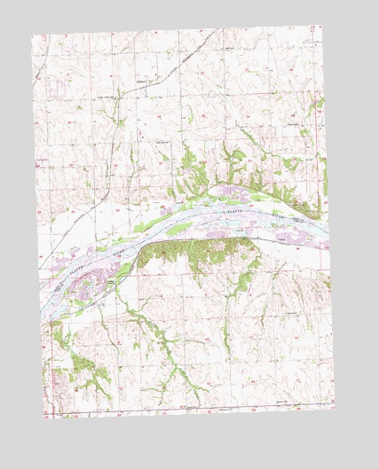
Cedar Creek, NE USGS Topographic Map
Click on map above to begin viewing in our Map Viewer.

This topographic map contains these locations and features:
Feature Name Type Latitude Longitude GNIS ID View Map
Becker School (historical)SchoolN41.0025°W96.0250°827270View Map
Bell SchoolSchoolN41.1183°W96.0420°827297View Map
Camp MahaLocaleN41.0642°W96.0086°827904View Map
Cedar CreekStreamN41.0400°W96.1150°827982View Map
Cedar CreekPopulated PlaceN41.0367°W96.0995°827994View Map
Cedar CreekLocaleN41.0369°W96.1008°1897987View Map
Cedar Creek Post OfficePost OfficeN41.0367°W96.1010°1897985View Map
Cedar Creek School (historical)SchoolN41.0367°W96.0995°1897986View Map
Cedar Creek Volunteer Fire DepartmentBuildingN41.0365°W96.0983°2553255View Map
Chase SchoolSchoolN41.0931°W96.0122°828106View Map
Crestview LodgeLocaleN41.0667°W96.0156°828458View Map
CullomLocaleN41.0558°W96.0236°1897828View Map
CullomPopulated PlaceN41.0558°W96.0236°835281View Map
Cullom School (historical)SchoolN41.0317°W96.0156°828514View Map
Eight Mile Grove Election PrecinctCivilN41.0088°W96.0616°1928847View Map
Fairview (historical)Populated PlaceN41.1000°W96.0503°1898122View Map
Fairview CemeteryCemeteryN41.1028°W96.0517°829227View Map
Fairview Election PrecinctCivilN41.0933°W96.0538°1928871View Map
Fairview Post Office (historical)Post OfficeN41.1000°W96.0503°1898123View Map
Fairview SchoolSchoolN41.0889°W96.0672°829247View Map
Glendale CemeteryCemeteryN41.0022°W96.1025°829536View Map
Glendale CreekStreamN41.0625°W96.0306°2054469View Map
Harvey DamDamN41.1000°W96.0053°1769916View Map
Harvey ReservoirReservoirN41.0999°W96.0044°1769917View Map
Heil SchoolSchoolN41.0022°W96.0633°829918View Map
KFAB-AM (Omaha)TowerN41.1197°W96.0020°837786View Map
KGBI-FM (Omaha)TowerN41.0431°W96.0675°837824View Map
Lutheran ChurchChurchN41.0014°W96.0453°830967View Map
P & R Airport (historical)AirportN41.0417°W96.0336°837518View Map
Platteview High SchoolSchoolN41.0919°W96.0796°1898281View Map
RichfieldPopulated PlaceN41.1083°W96.0753°832541View Map
Richfield (historical)LocaleN41.1083°W96.0753°1898094View Map
Richfield Census Designated PlaceCensusN41.1108°W96.0763°2583895View Map
Richfield Post Office (historical)Post OfficeN41.1083°W96.0753°1898095View Map
Saint Joseph ChurchChurchN41.0811°W96.1239°1898278View Map
Sarpy Center SchoolSchoolN41.1036°W96.0903°833229View Map
Sarpy CountyCivilN41.1129°W96.1120°835898View Map
Sarpy County Sheriff's OfficeBuildingN41.0899°W96.0417°1898286View Map
Sarpy County Sheriff's OfficeBuildingN41.0899°W96.0417°2739889View Map
Springfield CreekStreamN41.0461°W96.1200°833738View Map
Springfield QuarryMineN41.0697°W96.0769°2567324View Map
Turkey CreekStreamN41.0517°W96.0861°834205View Map
Village of Cedar CreekCivilN41.0451°W96.1016°2397580View Map
Younker CreekStreamN41.0447°W96.0386°2054876View Map

Note: Coordinates in the location and feature list above are referenced to NAD83 datum.


Copyright (C) 2008-2024 Ryan Niemi / Sunset Dynamics ... All Rights Reserved