TopoQuest Logo
Do you find TopoQuest useful?
Help keep TopoQuest running and adding new maps/features by donating!
Bitcoin:  19c7KJd3qBynnjoSw5npx9KScwjBe4ifkT
Litecoin:  LXs6TkuXGGXo1vDsWCkWVdjQX94eUKd6ui
Home View Maps Find Maps Find Places Resources & Links


Cayuga, New York Topographic Map

USGS Map Title: Cayuga, NY
USGS Map MRC: 42076H6
DRG (GeoTIFF) Download: o42076h6.tif


Neighboring USGS Topographic Map Quads:


  Savannah, NY  
43076A7
 

  Montezuma, NY  
43076A6
 

  Weedsport, NY  
43076A5
 

  Seneca Falls, NY  
42076H7
 

  Cayuga, NY  
42076H6
 

  Auburn, NY  
42076H5
 

  Romulus, NY  
42076G7
 

  Union Springs, NY  
42076G6
 

  Scipio Center, NY  
42076G5


Map MRC Location:

N43°
W77°
N43°
W76°
H8 H7 H6 H5 H4 H3 H2 H1
G8 G7 G6 G5 G4 G3 G2 G1
F8 F7 F6 F5 F4 F3 F2 F1
E8 E7 E6 E5 E4 E3 E2 E1
D8 D7 D6 D5 D4 D3 D2 D1
C8 C7 C6 C5 C4 C3 C2 C1
B8 B7 B6 B5 B4 B3 B2 B1
A8 A7 A6 A5 A4 A3 A2 A1
N42°
W77°
N42°
W76°

Cayuga, NY USGS 1:24K Topographic Map Preview:
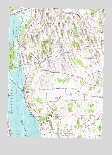
Cayuga, NY USGS Topographic Map
Click on map above to begin viewing in our Map Viewer.

This topographic map contains these locations and features:
Feature Name Type Latitude Longitude GNIS ID View Map
Aurelius Fire Department West StationBuildingN42.9378°W76.6874°2735024View Map
Beacon Bay MarinaHarborN42.9205°W76.7307°2598499View Map
Bennett's Mobile CourtPopulated PlaceN42.9821°W76.6924°2598481View Map
Black LakeLakeN42.9794°W76.7449°944139View Map
Cay and Sen Canal BridgeBridgeN42.9630°W76.7379°2614882View Map
CayugaPopulated PlaceN42.9190°W76.7263°946081View Map
Cayuga Campground MarinaLocaleN42.9003°W76.7494°2617476View Map
Cayuga Elementary SchoolSchoolN42.9169°W76.7224°2597456View Map
Cayuga Fire DepartmentBuildingN42.9185°W76.7263°2735023View Map
Clyde RiverStreamN42.9995°W76.7308°946942View Map
Cowan - Farnum CemeteryCemeteryN42.9302°W76.6266°2105779View Map
Cranebrook CemeteryCemeteryN42.9589°W76.6427°947705View Map
Cranebrook Golf CourseLocaleN42.9625°W76.6422°2598507View Map
Cranebrook Tree FarmLocaleN42.9619°W76.6456°2515532View Map
Cross RoadsPopulated PlaceN42.8778°W76.6833°972352View Map
Demont CreekStreamN42.9298°W76.7416°948292View Map
Fairchild CemeteryCemeteryN42.9865°W76.6839°2519214View Map
Finger Lakes Drive-InLocaleN42.9331°W76.6558°2557309View Map
FostervillePopulated PlaceN42.9581°W76.6730°950524View Map
Fosterville CemeteryCemeteryN42.9619°W76.6667°2519216View Map
Free Bridge CornersLocaleN42.9628°W76.7338°950656View Map
Kipp IslandIslandN42.9967°W76.7263°954701View Map
Lakeview CemeteryCemeteryN42.9136°W76.7262°954983View Map
Lamb CemeteryCemeteryN42.8825°W76.6645°2519219View Map
Lettie M Cook Memorial ForestForestN42.8937°W76.7030°955228View Map
Lock Number 1DamN42.9478°W76.7341°974707View Map
Lockview MarinaLocaleN42.9406°W76.7311°973504View Map
Maycumber Family CemeteryCemeteryN42.9326°W76.6376°2519217View Map
McArthur CemeteryCemeteryN42.9868°W76.6734°956717View Map
Mentz Church CemeteryCemeteryN42.9961°W76.6774°2519215View Map
Mentz CornersLocaleN42.9953°W76.6763°956968View Map
Mud LockPopulated PlaceN42.9465°W76.7361°972824View Map
O'Hara Dairy FarmsLocaleN42.9108°W76.6553°2515530View Map
OakwoodPopulated PlaceN42.8895°W76.6472°959186View Map
Polk CornersLocaleN42.9648°W76.6333°960861View Map
ReliusPopulated PlaceN42.9203°W76.6583°972994View Map
School Number 1 (historical)SchoolN42.9472°W76.7136°2105780View Map
School Number 2 (historical)SchoolN42.9347°W76.6378°2105781View Map
School Number 2 (historical)SchoolN42.9653°W76.6289°2105782View Map
School Number 5 (historical)SchoolN42.9228°W76.6667°2105783View Map
School Number 7 (historical)SchoolN42.9378°W76.6783°2105784View Map
School Number 8 (historical)SchoolN42.8958°W76.6722°2105785View Map
School Number 8 (historical)SchoolN42.9561°W76.6803°2105786View Map
School Number 9 (historical)SchoolN42.9161°W76.6275°2105787View Map
Smith CemeteryCemeteryN42.9110°W76.6352°2519218View Map
Town of AureliusCivilN42.9277°W76.6693°978697View Map
Village of CayugaCivilN42.9191°W76.7266°2391590View Map
Yawger CreekStreamN42.8862°W76.7086°973630View Map

Note: Coordinates in the location and feature list above are referenced to NAD83 datum.


Copyright (C) 2008-2024 Ryan Niemi / Sunset Dynamics ... All Rights Reserved