TopoQuest Logo
Do you find TopoQuest useful?
Help keep TopoQuest running and adding new maps/features by donating!
Bitcoin:  19c7KJd3qBynnjoSw5npx9KScwjBe4ifkT
Litecoin:  LXs6TkuXGGXo1vDsWCkWVdjQX94eUKd6ui
Home View Maps Find Maps Find Places Resources & Links


Carthage, Texas Topographic Map

USGS Map Title: Carthage, TX
USGS Map MRC: 32094B3
DRG (GeoTIFF) Download: o32094b3.tif


Neighboring USGS Topographic Map Quads:


  Harris Chapel, TX  
32094C4
 

  Grand Bluff, TX  
32094C3
 

  De Berry, TX  
32094C2
 

  Beckville, TX  
32094B4
 

  Carthage, TX  
32094B3
 

  River Hill, TX  
32094B2
 

  Lake Murvaul, TX  
32094A4
 

  Gary, TX  
32094A3
 

  Old Center, TX  
32094A2


Map MRC Location:

N33°
W95°
N33°
W94°
H8 H7 H6 H5 H4 H3 H2 H1
G8 G7 G6 G5 G4 G3 G2 G1
F8 F7 F6 F5 F4 F3 F2 F1
E8 E7 E6 E5 E4 E3 E2 E1
D8 D7 D6 D5 D4 D3 D2 D1
C8 C7 C6 C5 C4 C3 C2 C1
B8 B7 B6 B5 B4 B3 B2 B1
A8 A7 A6 A5 A4 A3 A2 A1
N32°
W95°
N32°
W94°

Carthage, TX USGS 1:24K Topographic Map Preview:
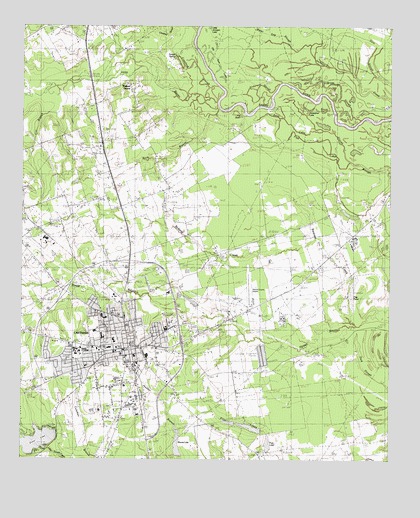
Carthage, TX USGS Topographic Map
Click on map above to begin viewing in our Map Viewer.

This topographic map contains these locations and features:
Feature Name Type Latitude Longitude GNIS ID View Map
1891 Panola County JailBuildingN32.1624°W94.3383°2014520View Map
Anderson SloughGutN32.2346°W94.2983°1372296View Map
Baker - Koonce Intermediate SchoolSchoolN32.1571°W94.3438°2008121View Map
Bean Lake SloughStreamN32.2118°W94.2641°1351645View Map
Buck BranchStreamN32.2257°W94.3127°1353117View Map
CarthagePopulated PlaceN32.1574°W94.3374°1353900View Map
Carthage City HallBuildingN32.1582°W94.3525°2753188View Map
Carthage DivisionCivilN32.1592°W94.3417°1938603View Map
Carthage Junior High SchoolSchoolN32.1599°W94.3477°2008125View Map
Carthage Police DepartmentBuildingN32.1564°W94.3428°2751188View Map
Carthage Post OfficePost OfficeN32.1549°W94.3394°2731746View Map
Carthage Primary SchoolSchoolN32.1621°W94.3524°2008126View Map
Carthage Volunteer Fire DepartmentBuildingN32.1563°W94.3431°2655327View Map
Church of ChristChurchN32.1682°W94.3494°2023817View Map
Church of Christ of CarthageChurchN32.1588°W94.3583°2023818View Map
City of CarthageCivilN32.1526°W94.3368°2409400View Map
Cox BranchStreamN32.2329°W94.3608°1355242View Map
Crawford SloughStreamN32.2285°W94.3124°1355330View Map
Cypress SloughGutN32.2310°W94.2666°1355521View Map
Davis ParkParkN32.1621°W94.3402°1355713View Map
Dixie LakeReservoirN32.1304°W94.3705°1356080View Map
Dixie Lake DamDamN32.1285°W94.3669°1854879View Map
East Texas Medical CenterHospitalN32.1661°W94.3467°2015740View Map
Fite CemeteryCemeteryN32.1865°W94.3727°1357368View Map
Flag PondLakeN32.1740°W94.2628°1357410View Map
Friendship ChurchChurchN32.1907°W94.3713°1357751View Map
Garner SpringSpringN32.2413°W94.3237°1357896View Map
Horseshoe LakeLakeN32.2262°W94.2784°1359658View Map
Hudson MastPopulated PlaceN32.1879°W94.2624°1889982View Map
Irons BayouStreamN32.2288°W94.3083°1374236View Map
KGAS-AM (Carthage)TowerN32.1535°W94.3146°1385524View Map
Libby Elementary SchoolSchoolN32.1616°W94.3485°2008128View Map
Liberty ChapelChurchN32.1766°W94.2783°1361152View Map
Little Jernigan LakeLakeN32.2499°W94.3117°1361389View Map
Little Sixmile CreekStreamN32.1288°W94.3746°1374608View Map
Moore LakeReservoirN32.1265°W94.3211°1854876View Map
Moore LakeLakeN32.1302°W94.2910°1363110View Map
Moore Lake DamDamN32.1252°W94.3219°1854875View Map
Mount Zion ChurchChurchN32.1596°W94.3366°2023820View Map
Old River LakesLakeN32.2393°W94.3088°1364476View Map
Panola CountyCivilN32.1624°W94.3056°1383968View Map
Panola County Airport-Sharpe FieldAirportN32.1761°W94.2988°1384781View Map
Panola County Constable's Office Precinct 1BuildingN32.1552°W94.3418°2751394View Map
Panola County Constable's Office Precinct 2BuildingN32.1555°W94.3412°2751354View Map
Panola County Constable's Office Precinct 3BuildingN32.1554°W94.3412°2751353View Map
Panola County Detention CenterBuildingN32.1544°W94.3419°2738677View Map
Panola County Heritage MuseumBuildingN32.1566°W94.3377°2014521View Map
Panola County Historical Museum and LibraryBuildingN32.1582°W94.3391°2032315View Map
Panola County Sheriff's OfficeBuildingN32.1552°W94.3417°2751126View Map
Panola General Hospital HeliportAirportN32.1663°W94.3460°1386349View Map
Panola Junior CollegeSchoolN32.1563°W94.3549°1364752View Map
Parkway Baptist ChurchChurchN32.1563°W94.3521°2023814View Map
Poss LakeReservoirN32.1294°W94.2913°1854872View Map
Poss Lake DamDamN32.1285°W94.2919°1854871View Map
Prior LakeLakeN32.1349°W94.2988°1365797View Map
Prior Lake Number 1ReservoirN32.1358°W94.3044°1854874View Map
Prior Lake Number 1 DamDamN32.1368°W94.3035°1854873View Map
Prior Lake Number 2ReservoirN32.1344°W94.2972°1854870View Map
Prior Lake Number 2 DamDamN32.1352°W94.2935°1854869View Map
Rehobeth ChurchChurchN32.2154°W94.3471°1366328View Map
Respass CreekStreamN32.1646°W94.2613°1366362View Map
Roberts CreekStreamN32.1888°W94.2752°1366589View Map
Saint Pauls Presbyterian ChurchChurchN32.1604°W94.3677°2023819View Map
Saint Williams Catholic ChurchChurchN32.1716°W94.3616°2023816View Map
Southside Baptist ChurchChurchN32.1463°W94.3449°2023815View Map
Tex Ritter MuseumBuildingN32.1568°W94.3438°2014522View Map
Texas Forest Service Carthage OfficeBuildingN32.1475°W94.3233°2655584View Map
The BasinLakeN32.2242°W94.3011°1369769View Map
Walker CemeteryCemeteryN32.1502°W94.3155°1370753View Map
Walnut GrovePopulated PlaceN32.2315°W94.3369°1380738View Map
Water Gap SloughStreamN32.2399°W94.2758°1370905View Map

Note: Coordinates in the location and feature list above are referenced to NAD83 datum.


Copyright (C) 2008-2024 Ryan Niemi / Sunset Dynamics ... All Rights Reserved