TopoQuest Logo
Do you find TopoQuest useful?
Help keep TopoQuest running and adding new maps/features by donating!
Bitcoin:  19c7KJd3qBynnjoSw5npx9KScwjBe4ifkT
Litecoin:  LXs6TkuXGGXo1vDsWCkWVdjQX94eUKd6ui
Home View Maps Find Maps Find Places Resources & Links


Lime, Oregon Topographic Map

USGS Map Title: Lime, OR
USGS Map MRC: 44117D3
DRG (GeoTIFF) Download: o44117d3.tif


Neighboring USGS Topographic Map Quads:


  Durkee, OR  
44117E4
 

  Big Lookout Mountain, OR  
44117E3
 

  Connor Creek, OR  
44117E2
 

  Rye Valley, OR  
44117D4
 

  Lime, OR  
44117D3
 

  Henley Basin, ID  
44117D2
 

  Birch Creek Meadow, OR  
44117C4
 

  Huntington, OR  
44117C3
 

  Olds Ferry, ID  
44117C2


Map MRC Location:

N45°
W118°
N45°
W117°
H8 H7 H6 H5 H4 H3 H2 H1
G8 G7 G6 G5 G4 G3 G2 G1
F8 F7 F6 F5 F4 F3 F2 F1
E8 E7 E6 E5 E4 E3 E2 E1
D8 D7 D6 D5 D4 D3 D2 D1
C8 C7 C6 C5 C4 C3 C2 C1
B8 B7 B6 B5 B4 B3 B2 B1
A8 A7 A6 A5 A4 A3 A2 A1
N44°
W118°
N44°
W117°

Lime, OR USGS 1:24K Topographic Map Preview:
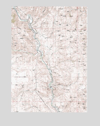
Lime, OR USGS Topographic Map
Click on map above to begin viewing in our Map Viewer.

This topographic map contains these locations and features:
Feature Name Type Latitude Longitude GNIS ID View Map
Anderson GulchValleyN44.4479°W117.3707°1116933View Map
Arrastra GulchValleyN44.4985°W117.3732°1158858View Map
Back Swimmer SpringSpringN44.4681°W117.2615°1133319View Map
Bay Horse SpringSpringN44.4559°W117.2545°1133328View Map
Benson SpringSpringN44.4580°W117.2761°1133324View Map
Billy Gulch SpringSpringN44.4609°W117.2559°1133327View Map
Binder GulchValleyN44.3782°W117.2910°1133349View Map
Binder SpringSpringN44.3922°W117.2765°1133348View Map
Binder Spring Number TwoSpringN44.3926°W117.2720°1133347View Map
Boat Dock SpringSpringN44.3792°W117.2546°1133353View Map
Bragg CreekStreamN44.4221°W117.3107°1131843View Map
Brush SpringSpringN44.3849°W117.2635°1133351View Map
Brush Spring Number TwoSpringN44.3847°W117.2637°1133334View Map
Caribou BarBarN44.4543°W117.3299°1118607View Map
Caviness Spring Number TwoSpringN44.4712°W117.2696°1133318View Map
Chaud SpringSpringN44.4890°W117.2694°1133316View Map
Chimney CreekStreamN44.4674°W117.3360°1118895View Map
Chukar SpringSpringN44.3960°W117.2569°1133346View Map
Clear CreekStreamN44.4471°W117.3580°1118992View Map
Divide SpringSpringN44.4435°W117.2543°1133331View Map
DixieLocaleN44.4685°W117.3338°1136221View Map
Dixie CreekStreamN44.4463°W117.3305°1119968View Map
Dixie Post Office (historical)Post OfficeN44.4685°W117.3338°1165165View Map
Dyne SpringSpringN44.4471°W117.2678°1133330View Map
E T ReservoirReservoirN44.4194°W117.3658°1133340View Map
East Morgan SpringSpringN44.4726°W117.2547°1133320View Map
Goodman CreekStreamN44.3904°W117.3068°1121229View Map
Heiney CreekStreamN44.4935°W117.2577°1121738View Map
Hogback CreekStreamN44.4891°W117.3224°1121884View Map
Jett (historical)Populated PlaceN44.4263°W117.3121°1131844View Map
Jett CreekStreamN44.4257°W117.3135°1122419View Map
Jett Post Office (historical)Post OfficeN44.4263°W117.3121°1165454View Map
Jett SpringSpringN44.4352°W117.2644°1133332View Map
Jordan CreekStreamN44.4799°W117.3435°1122525View Map
Juniper Mountain WaterholeLakeN44.4682°W117.3645°1133354View Map
Juniper Mountain Waterhole Number TwoLakeN44.4621°W117.3610°1133335View Map
Junkpile SpringSpringN44.4530°W117.3689°1133337View Map
LimePopulated PlaceN44.4066°W117.3113°1167713View Map
Lime - Dixie CemeteryCemeteryN44.4224°W117.3066°1131850View Map
Lime Post Office (historical)Post OfficeN44.4066°W117.3113°1165542View Map
Lucky SpringSpringN44.4896°W117.2942°1133359View Map
Marble CreekStreamN44.4091°W117.3077°1123750View Map
Marble Creek SpringSpringN44.4017°W117.2790°1133344View Map
Microwave SpringSpringN44.4314°W117.2522°1133333View Map
Montezuma SpringSpringN44.4710°W117.2993°1133314View Map
Morgan MountainSummitN44.4710°W117.2782°1124359View Map
Morgan Mountain SpringSpringN44.4635°W117.2789°1133322View Map
Morgan Mountain Spring Number TwoSpringN44.4640°W117.2898°1133321View Map
Nay SpringSpringN44.4574°W117.2707°1133326View Map
New Seeding Spring Number OneSpringN44.4970°W117.2957°1133356View Map
New Seeding Spring Number ThreeSpringN44.4883°W117.2788°1133358View Map
New Seeding Spring Number TwoSpringN44.4888°W117.2852°1133357View Map
Overhead Flat SpringSpringN44.3826°W117.2873°1133350View Map
Pipeline SpringSpringN44.4252°W117.3381°1133339View Map
Pole GulchValleyN44.4954°W117.2618°1125539View Map
Porcupine SpringSpringN44.4935°W117.2833°1133360View Map
Powell CreekStreamN44.4293°W117.3152°1125633View Map
Powell SpringSpringN44.4600°W117.2707°1133325View Map
Quartz GulchValleyN44.4852°W117.3430°1125733View Map
Quick Step SpringSpringN44.4658°W117.2974°1133323View Map
Reiber CreekStreamN44.4416°W117.3246°1131842View Map
Rim SpringSpringN44.4046°W117.3573°1133343View Map
Sidehill Spring Number TwoSpringN44.4564°W117.3698°1133336View Map
Sisley CreekStreamN44.4971°W117.3705°1127006View Map
Smith SpringSpringN44.4777°W117.2852°1133315View Map
Spring GulchValleyN44.4902°W117.2543°1133361View Map
Spring Gulch SpringSpringN44.3846°W117.2580°1133352View Map
Storie GulchValleyN44.4554°W117.3344°1131841View Map
Storie Spring Number TwoSpringN44.4806°W117.3192°1133311View Map
Table Mountain SpringSpringN44.4073°W117.3555°1133342View Map
Table Mountain Spring Number TwoSpringN44.4172°W117.3548°1133341View Map
Tate Spring Number TwoSpringN44.4496°W117.2570°1133329View Map
Triangle ReservoirReservoirN44.4071°W117.3685°1133355View Map
Walnut SpringSpringN44.4827°W117.3019°1133312View Map
Washout SpringSpringN44.4774°W117.2944°1133313View Map
Waterbirch SpringSpringN44.4774°W117.2585°1133317View Map
Watering Trough DrawValleyN44.4488°W117.3577°1128725View Map
WeatherbyPopulated PlaceN44.4985°W117.3713°1136882View Map
Weatherby Post Office (historical)Post OfficeN44.4985°W117.3713°1166138View Map
Weatherby Safety Rest AreaLocaleN44.4957°W117.3663°1987587View Map
Willow SpringSpringN44.4253°W117.2527°1133345View Map
Y ReservoirLakeN44.4559°W117.3567°1133338View Map

Note: Coordinates in the location and feature list above are referenced to NAD83 datum.


Copyright (C) 2008-2024 Ryan Niemi / Sunset Dynamics ... All Rights Reserved