TopoQuest Logo
Do you find TopoQuest useful?
Help keep TopoQuest running and adding new maps/features by donating!
Bitcoin:  19c7KJd3qBynnjoSw5npx9KScwjBe4ifkT
Litecoin:  LXs6TkuXGGXo1vDsWCkWVdjQX94eUKd6ui
Home View Maps Find Maps Find Places Resources & Links


Elk Springs, Montana Topographic Map

USGS Map Title: Elk Springs, MT
USGS Map MRC: 44111F6
DRG (GeoTIFF) Download: o44111f6.tif


Neighboring USGS Topographic Map Quads:


  Windy Hill, MT  
44111G7
 

  Freezeout Mountain, MT  
44111G6
 

  Cliff Lake, MT  
44111G5
 

  Lower Red Rock Lake, MT  
44111F7
 

  Elk Springs, MT  
44111F6
 

  Hidden Lake Bench, MT  
44111F5
 

  Slide Mountain, MT  
44111E7
 

  Upper Red Rock Lake, MT  
44111E6
 

  Mount Jefferson, MT  
44111E5


Map MRC Location:

N45°
W112°
N45°
W111°
H8 H7 H6 H5 H4 H3 H2 H1
G8 G7 G6 G5 G4 G3 G2 G1
F8 F7 F6 F5 F4 F3 F2 F1
E8 E7 E6 E5 E4 E3 E2 E1
D8 D7 D6 D5 D4 D3 D2 D1
C8 C7 C6 C5 C4 C3 C2 C1
B8 B7 B6 B5 B4 B3 B2 B1
A8 A7 A6 A5 A4 A3 A2 A1
N44°
W112°
N44°
W111°

Elk Springs, MT USGS 1:24K Topographic Map Preview:
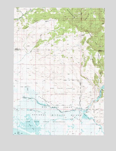
Elk Springs, MT USGS Topographic Map
Click on map above to begin viewing in our Map Viewer.

This topographic map contains these locations and features:
Feature Name Type Latitude Longitude GNIS ID View Map
13S01E29CAB_01 SpringSpringN44.6716°W111.6319°807160View Map
13S01E31DCAB01 SpringSpringN44.6538°W111.6479°807138View Map
13S01W04DCC_01 SpringSpringN44.7244°W111.7291°807197View Map
13S01W10BBA_01 SpringSpringN44.7249°W111.7161°807198View Map
13S01W12DAAC01 SpringSpringN44.7127°W111.6611°807194View Map
13S01W27BBAC01 WellWellN44.6777°W111.7175°807169View Map
13S01W28BCBB01 WellWellN44.6749°W111.7405°807164View Map
13S01W28DDD_01 WellWellN44.6652°W111.7175°807156View Map
Antelope PondLakeN44.6495°W111.7296°801806View Map
Culver SpringsSpringN44.6285°W111.6272°781984View Map
Culver Springs DamDamN44.6316°W111.6291°798730View Map
Elk Lake Recreation SiteLocaleN44.6699°W111.6314°794868View Map
Elk SpringsSpringN44.6513°W111.6489°783125View Map
Hackett CreekStreamN44.6485°W111.6530°784434View Map
Hoodoo PassGapN44.7349°W111.6266°784989View Map
Horse CreekStreamN44.6599°W111.6380°785026View Map
Lobo CreekStreamN44.7433°W111.7380°786408View Map
MacDonald PondLakeN44.6486°W111.6517°798848View Map
Narrows CreekStreamN44.6705°W111.6300°787913View Map
Red Rock Lakes National Wildlife RefugeParkN44.6377°W111.7369°806844View Map
Selby ResortLocaleN44.6710°W111.6314°790207View Map
Snowshoe PassGapN44.7366°W111.7108°790800View Map
Swan LakeLakeN44.6331°W111.7265°791784View Map
The NarrowsChannelN44.6699°W111.6302°793668View Map
Two Drink SpringsSpringN44.7230°W111.6578°792549View Map
Widgeon PondLakeN44.6430°W111.6483°798851View Map
Widgeon Pond DamDamN44.6366°W111.6558°795720View Map

Note: Coordinates in the location and feature list above are referenced to NAD83 datum.


Copyright (C) 2008-2024 Ryan Niemi / Sunset Dynamics ... All Rights Reserved