TopoQuest Logo
Do you find TopoQuest useful?
Help keep TopoQuest running and adding new maps/features by donating!
Bitcoin:  19c7KJd3qBynnjoSw5npx9KScwjBe4ifkT
Litecoin:  LXs6TkuXGGXo1vDsWCkWVdjQX94eUKd6ui
Home View Maps Find Maps Find Places Resources & Links


Sardis SE, Mississippi Topographic Map

USGS Map Title: Sardis SE, MS
USGS Map MRC: 34089C7
DRG (GeoTIFF) Download: o34089c7.tif


Neighboring USGS Topographic Map Quads:


  Sardis, MS  
34089D8
 

  Sardis Dam, MS  
34089D7
 

  Coles Point, MS  
34089D6
 

  Batesville, MS  
34089C8
 

  Sardis SE, MS  
34089C7
 

  Splinter, MS  
34089C6
 

  Courtland, MS  
34089B8
 

  Shuford, MS  
34089B7
 

  Water Valley West, MS  
34089B6


Map MRC Location:

N35°
W90°
N35°
W89°
H8 H7 H6 H5 H4 H3 H2 H1
G8 G7 G6 G5 G4 G3 G2 G1
F8 F7 F6 F5 F4 F3 F2 F1
E8 E7 E6 E5 E4 E3 E2 E1
D8 D7 D6 D5 D4 D3 D2 D1
C8 C7 C6 C5 C4 C3 C2 C1
B8 B7 B6 B5 B4 B3 B2 B1
A8 A7 A6 A5 A4 A3 A2 A1
N34°
W90°
N34°
W89°

Sardis SE, MS USGS 1:24K Topographic Map Preview:
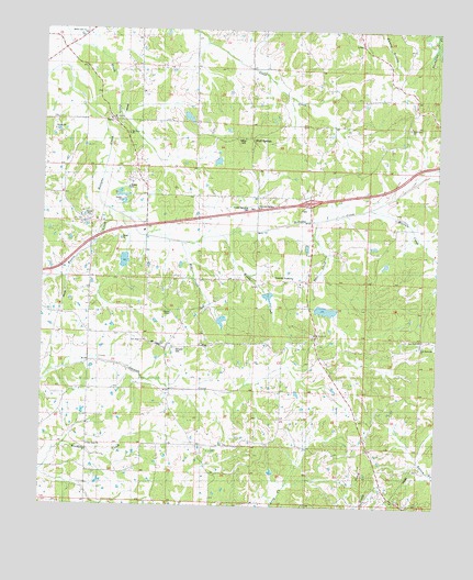
Sardis SE, MS USGS Topographic Map
Click on map above to begin viewing in our Map Viewer.

This topographic map contains these locations and features:
Feature Name Type Latitude Longitude GNIS ID View Map
Beland Petree Pond DamDamN34.3184°W89.7968°682579View Map
Black Jack CemeteryCemeteryN34.3501°W89.7590°667223View Map
Black Jack ChurchChurchN34.3501°W89.7590°667225View Map
Black Jack SchoolSchoolN34.3618°W89.7634°667227View Map
Bluff SpringsPopulated PlaceN34.3459°W89.8087°685641View Map
Bluff Springs CemeteryCemeteryN34.3462°W89.8092°667339View Map
Bluff Springs ChurchChurchN34.3462°W89.8093°667344View Map
Bluff Springs SchoolSchoolN34.3462°W89.8093°667346View Map
Brassell ChapelChurchN34.3004°W89.8337°667517View Map
Central AcademyPopulated PlaceN34.3048°W89.8170°668273View Map
Central Academy ChurchChurchN34.3287°W89.8070°668277View Map
Central Agency (historical)LocaleN34.2918°W89.8356°685650View Map
Deer CreekStreamN34.3254°W89.7881°669198View Map
East Batesville ChurchChurchN34.2926°W89.7551°685666View Map
Forest Memorial ParkCemeteryN34.3284°W89.8084°685676View Map
Good Hope ChurchChurchN34.2654°W89.8598°670487View Map
Harris CreekStreamN34.3279°W89.8543°685680View Map
Henderson SchoolSchoolN34.2657°W89.8148°671105View Map
Hotopha Creek Watershed Y-10a-47 DamDamN34.3168°W89.8184°682578View Map
Hotopha Creek Watershed Y-10a-47a DamDamN34.3034°W89.8034°682571View Map
Hotopha Creek Watershed Y-10a-52 DamDamN34.3001°W89.7884°682568View Map
Hotopha Creek Watershed Y-10a-62 DamDamN34.2984°W89.8184°682565View Map
Hotopha Creek Y-10a-43 DamDamN34.3151°W89.8484°682577View Map
Hotopha Creek Y-10a-66 DamDamN34.3151°W89.7501°682576View Map
Inman CreekStreamN34.3737°W89.7523°671712View Map
John E Dunlap Pond DamDamN34.3418°W89.8201°682591View Map
Lester Hill SchoolSchoolN34.3515°W89.8540°672411View Map
Marcum CreekStreamN34.3284°W89.7718°673132View Map
Mississippi No Name 219 DamDamN34.3534°W89.8334°682600View Map
Mount Gillian CemeteryCemeteryN34.3512°W89.8526°674010View Map
Mount Gillian ChurchChurchN34.3507°W89.8534°674011View Map
Mount OlivetPopulated PlaceN34.2937°W89.7881°707425View Map
Mount Olivet CemeteryCemeteryN34.2954°W89.7892°674178View Map
Mount Olivet ChurchChurchN34.2954°W89.7890°674179View Map
Mount Olivet Fire Department Station 4BuildingN34.2946°W89.7904°2665981View Map
Mount Olivet School (historical)SchoolN34.2954°W89.7884°707426View Map
Mount Terza CemeteryCemeteryN34.3476°W89.8481°674285View Map
Mount Terza ChurchChurchN34.3476°W89.8481°674286View Map
New Enon ChurchChurchN34.2940°W89.7548°685703View Map
New Hope CemeteryCemeteryN34.2932°W89.8423°674668View Map
New Hope ChurchChurchN34.2932°W89.8423°674740View Map
New Hope SchoolSchoolN34.2932°W89.8423°674754View Map
Nutts Shop (historical)LocaleN34.2807°W89.8501°685709View Map
Sardis Lake ChurchChurchN34.3737°W89.8629°685738View Map
Spring Port (historical)LocaleN34.3546°W89.7779°685749View Map
Supervisor District 4CivilN34.2815°W89.8027°712020View Map
TerzaPopulated PlaceN34.3515°W89.8543°692355View Map

Note: Coordinates in the location and feature list above are referenced to NAD83 datum.


Copyright (C) 2008-2024 Ryan Niemi / Sunset Dynamics ... All Rights Reserved