TopoQuest Logo
Do you find TopoQuest useful?
Help keep TopoQuest running and adding new maps/features by donating!
Bitcoin:  19c7KJd3qBynnjoSw5npx9KScwjBe4ifkT
Litecoin:  LXs6TkuXGGXo1vDsWCkWVdjQX94eUKd6ui
Home View Maps Find Maps Find Places Resources & Links


Round Mountain, California Topographic Map

USGS Map Title: Round Mountain, CA
USGS Map MRC: 36119G5
DRG (GeoTIFF) Download: o36119g5.tif


Neighboring USGS Topographic Map Quads:


  Friant, CA  
36119H6
 

  Academy, CA  
36119H5
 

  Humphreys Station, CA  
36119H4
 

  Clovis, CA  
36119G6
 

  Round Mountain, CA  
36119G5
 

  Piedra, CA  
36119G4
 

  Malaga, CA  
36119F6
 

  Sanger, CA  
36119F5
 

  Wahtoke, CA  
36119F4


Map MRC Location:

N37°
W120°
N37°
W119°
H8 H7 H6 H5 H4 H3 H2 H1
G8 G7 G6 G5 G4 G3 G2 G1
F8 F7 F6 F5 F4 F3 F2 F1
E8 E7 E6 E5 E4 E3 E2 E1
D8 D7 D6 D5 D4 D3 D2 D1
C8 C7 C6 C5 C4 C3 C2 C1
B8 B7 B6 B5 B4 B3 B2 B1
A8 A7 A6 A5 A4 A3 A2 A1
N36°
W120°
N36°
W119°

Round Mountain, CA USGS 1:24K Topographic Map Preview:
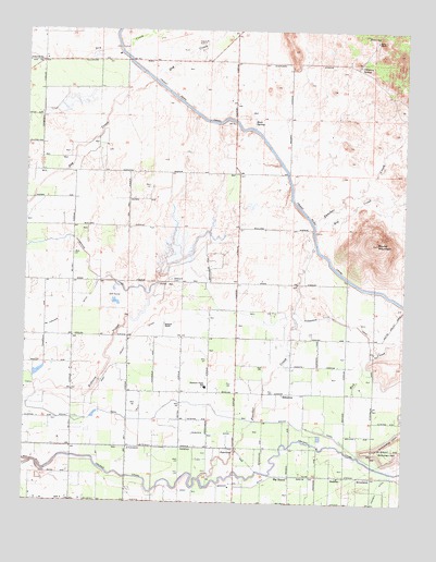
Round Mountain, CA USGS Topographic Map
Click on map above to begin viewing in our Map Viewer.

This topographic map contains these locations and features:
Feature Name Type Latitude Longitude GNIS ID View Map
Baird RanchLocaleN36.8725°W119.5110°218533View Map
Baker FarmLocaleN36.7906°W119.5356°2703417View Map
Big BunchPopulated PlaceN36.7572°W119.5382°1658051View Map
Blasinger RanchLocaleN36.7619°W119.6218°1682751View Map
Blue Jay RanchLocaleN36.7744°W119.5879°1682752View Map
Chimney SpringSpringN36.8661°W119.5162°221011View Map
Collins (historical)Populated PlaceN36.8663°W119.6207°1665605View Map
Daddino's Egg RanchLocaleN36.7897°W119.6178°2677537View Map
East Branch DitchCanalN36.7544°W119.5518°222853View Map
EdmistonPopulated PlaceN36.7788°W119.5404°1658475View Map
Fairmont Elementary SchoolSchoolN36.7806°W119.5660°223343View Map
Fairview DitchCanalN36.7683°W119.5635°223350View Map
Fairview School (historical)SchoolN36.7647°W119.5690°1665615View Map
Fancher CreekStreamN36.7563°W119.5671°223383View Map
Fancher RanchLocaleN36.7519°W119.5976°1682755View Map
Fresno CanalCanalN36.7666°W119.5343°233911View Map
Fresno County Fire Protection District Station 86 Clovis LakesBuildingN36.8077°W119.5793°2624310View Map
Gould CanalCanalN36.7719°W119.6046°224359View Map
Gray Colony DitchCanalN36.7919°W119.5918°224516View Map
Gray Colony School (historical)SchoolN36.7938°W119.5904°1665626View Map
Hansen DitchCanalN36.7538°W119.5087°224884View Map
Hog CreekStreamN36.8225°W119.5293°225392View Map
Home SpringSpringN36.8737°W119.5102°225500View Map
Kindsvater Ranch AirportAirportN36.8506°W119.5088°1653353View Map
KTHT-FM (Fresno)TowerN36.8186°W119.5101°1662873View Map
Lindsay School (historical)SchoolN36.7505°W119.5262°1665637View Map
McFarlane DitchCanalN36.7991°W119.6101°228358View Map
McLaglen RanchLocaleN36.8444°W119.5996°1682760View Map
Mud CreekStreamN36.7675°W119.5224°229226View Map
Redbank 1017 DamDamN36.8100°W119.5810°1664152View Map
Redbank CemeteryCemeteryN36.8090°W119.5779°231396View Map
Redbank RanchLocaleN36.8188°W119.5660°1682762View Map
Redbank School (historical)SchoolN36.8227°W119.6010°1665654View Map
Redbank SloughGutN36.7836°W119.6007°231398View Map
RiverbendPopulated PlaceN36.7569°W119.5112°252779View Map
Rock SpringSpringN36.8508°W119.5510°231744View Map
Round MountainSummitN36.8188°W119.5101°231958View Map
Round Mountain School (historical)SchoolN36.7933°W119.5376°1665661View Map
Sanger DivisionCivilN36.7626°W119.5532°1935285View Map
Sunland RanchLocaleN36.7975°W119.5793°235783View Map
ZedikerPopulated PlaceN36.7572°W119.5240°1660225View Map

Note: Coordinates in the location and feature list above are referenced to NAD83 datum.


Copyright (C) 2008-2024 Ryan Niemi / Sunset Dynamics ... All Rights Reserved