TopoQuest Logo
Do you find TopoQuest useful?
Help keep TopoQuest running and adding new maps/features by donating!
Bitcoin:  19c7KJd3qBynnjoSw5npx9KScwjBe4ifkT
Litecoin:  LXs6TkuXGGXo1vDsWCkWVdjQX94eUKd6ui
Home View Maps Find Maps Find Places Resources & Links


Lineville East, Alabama Topographic Map

USGS Map Title: Lineville East, AL
USGS Map MRC: 33085C6
DRG (GeoTIFF) Download: o33085c6.tif


Neighboring USGS Topographic Map Quads:


  Cheaha Mountain, AL  
33085D7
 

  Delta, AL  
33085D6
 

  Micaville, AL  
33085D5
 

  Lineville West, AL  
33085C7
 

  Lineville East, AL  
33085C6
 

  Ofelia, AL  
33085C5
 

  Gibsonville, AL  
33085B7
 

  Mellow Valley, AL  
33085B6
 

  Wadley North, AL  
33085B5


Map MRC Location:

N34°
W86°
N34°
W85°
H8 H7 H6 H5 H4 H3 H2 H1
G8 G7 G6 G5 G4 G3 G2 G1
F8 F7 F6 F5 F4 F3 F2 F1
E8 E7 E6 E5 E4 E3 E2 E1
D8 D7 D6 D5 D4 D3 D2 D1
C8 C7 C6 C5 C4 C3 C2 C1
B8 B7 B6 B5 B4 B3 B2 B1
A8 A7 A6 A5 A4 A3 A2 A1
N33°
W86°
N33°
W85°

Lineville East, AL USGS 1:24K Topographic Map Preview:
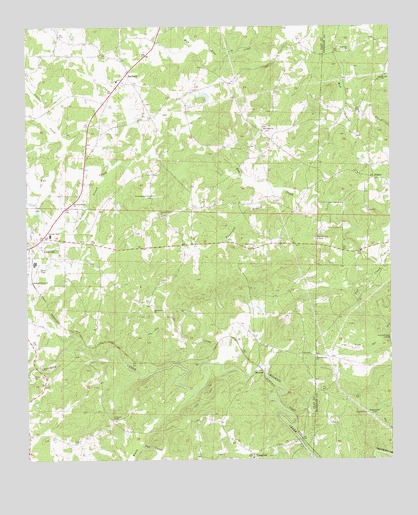
Lineville East, AL USGS Topographic Map
Click on map above to begin viewing in our Map Viewer.

This topographic map contains these locations and features:
Feature Name Type Latitude Longitude GNIS ID View Map
Abner (historical)Populated PlaceN33.2924°W85.6586°139656View Map
BarfieldPopulated PlaceN33.3612°W85.7158°113470View Map
Barfield CemeteryCemeteryN33.3579°W85.7161°1805367View Map
Barfield ChurchChurchN33.3584°W85.7166°163629View Map
Barfield Junior High SchoolSchoolN33.3593°W85.7186°139657View Map
Barfield Volunteer Fire DepartmentBuildingN33.3627°W85.7146°2683177View Map
Bartlett Crossroads (historical)LocaleN33.3715°W85.7069°139658View Map
Benjamin ProspectMineN33.2593°W85.6541°151068View Map
BerwickPopulated PlaceN33.2757°W85.6694°156055View Map
Buck CreekStreamN33.2729°W85.7486°159264View Map
Center School (historical)SchoolN33.2712°W85.7247°154198View Map
Christiana ChurchChurchN33.3676°W85.6397°116105View Map
Clay Community ChurchChurchN33.2537°W85.7494°163632View Map
Cockrell Placer MineMineN33.2534°W85.6616°151070View Map
Colemans ChapelChurchN33.2615°W85.7194°151734View Map
Corinth Volunteer Fire DepartmentBuildingN33.2539°W85.6605°2683192View Map
Court Hill Post Office (historical)Post OfficeN33.3107°W85.7022°166093View Map
CragfordPopulated PlaceN33.2509°W85.6725°164043View Map
Cragford CemeteryCemeteryN33.2507°W85.6716°163634View Map
Cragford ChurchChurchN33.2543°W85.6641°151071View Map
Cragford ChurchChurchN33.2507°W85.6727°164198View Map
Cragford Junior High School (historical)SchoolN33.2509°W85.6727°148934View Map
Cragford Post OfficePost OfficeN33.2551°W85.6580°2789054View Map
DennyLocaleN33.2612°W85.6838°154199View Map
DinglerPopulated PlaceN33.3312°W85.6308°156272View Map
Dinglers Chapel CemeteryCemeteryN33.3332°W85.6361°1730269View Map
Dinglers Chapel ChurchChurchN33.3329°W85.6358°164199View Map
East Mill (historical)LocaleN33.2571°W85.6588°139664View Map
Flat RockSummitN33.2826°W85.6391°118388View Map
Flat Rock Post Office (historical)Post OfficeN33.3682°W85.7077°166094View Map
Grays Mill (historical)LocaleN33.3693°W85.6600°139667View Map
Griffin MineMineN33.3340°W85.6908°157673View Map
Grizzel ProspectMineN33.2662°W85.6619°151069View Map
Hurricane BranchStreamN33.3265°W85.6627°120572View Map
Jeter BranchStreamN33.3329°W85.7225°120883View Map
Lineville Club LakeReservoirN33.3568°W85.6850°131469View Map
Lineville DamDamN33.3568°W85.6850°131470View Map
Little CreekStreamN33.2773°W85.6836°121755View Map
McCollum Baptist ChurchChurchN33.3451°W85.6691°122487View Map
McCollum CemeteryCemeteryN33.3454°W85.6686°1805391View Map
McCollum School (historical)SchoolN33.3451°W85.6688°139676View Map
New Fellowship ChurchChurchN33.3243°W85.7352°123748View Map
New Harmony ChurchChurchN33.2798°W85.6508°123755View Map
New Hope ChurchChurchN33.3746°W85.7013°151072View Map
New Hope School (historical)SchoolN33.3743°W85.7005°139679View Map
Old Pleasant Grove CemeteryCemeteryN33.3259°W85.7061°164094View Map
Orrs Gin (historical)LocaleN33.2865°W85.6725°139680View Map
Pine Grove CemeteryCemeteryN33.3134°W85.6497°1805462View Map
Pine Grove ChurchChurchN33.3137°W85.6502°124795View Map
Pine Grove Volunteer Fire DepartmentBuildingN33.3127°W85.6591°2683193View Map
Pleasant Grove Baptist ChurchChurchN33.3207°W85.7038°124958View Map
Pleasant Grove CemeteryCemeteryN33.3201°W85.7036°1730273View Map
Pleasant Hill ChurchChurchN33.3601°W85.6269°125002View Map
Prairie CreekStreamN33.3362°W85.7372°160441View Map
Shady Grove ChurchChurchN33.3115°W85.6716°126610View Map
ShilohPopulated PlaceN33.2573°W85.7494°151074View Map
Spring Hill Baptist ChurchChurchN33.2940°W85.7061°153536View Map
Spring Hill School (historical)SchoolN33.2940°W85.7061°139683View Map
Sweetwater CemeteryCemeteryN33.2629°W85.6313°127591View Map
Union Gin (historical)LocaleN33.3668°W85.7088°151073View Map
WANL-AM (Lineville)TowerN33.3015°W85.7341°161005View Map
Youngs Chapel ChurchChurchN33.3254°W85.6933°164213View Map

Note: Coordinates in the location and feature list above are referenced to NAD83 datum.


Copyright (C) 2008-2024 Ryan Niemi / Sunset Dynamics ... All Rights Reserved