TopoQuest Logo
Do you find TopoQuest useful?
Help keep TopoQuest running and adding new maps/features by donating!
Bitcoin:  19c7KJd3qBynnjoSw5npx9KScwjBe4ifkT
Litecoin:  LXs6TkuXGGXo1vDsWCkWVdjQX94eUKd6ui
Home View Maps Find Maps Find Places Resources & Links


Alpine Plateau, Colorado Topographic Map

USGS Map Title: Alpine Plateau, CO
USGS Map MRC: 38107B3
DRG (GeoTIFF) Download: o38107b3.tif


Neighboring USGS Topographic Map Quads:


  Lost Lake, CO  
38107C4
 

  Poison Draw, CO  
38107C3
 

  Gateview, CO  
38107C2
 

  Sheep Mountain, CO  
38107B4
 

  Alpine Plateau, CO  
38107B3
 

  Powderhorn Lakes, CO  
38107B2
 

  Uncompahgre Peak, CO  
38107A4
 

  Lake City, CO  
38107A3
 

  Cannibal Plateau, CO  
38107A2


Map MRC Location:

N39°
W108°
N39°
W107°
H8 H7 H6 H5 H4 H3 H2 H1
G8 G7 G6 G5 G4 G3 G2 G1
F8 F7 F6 F5 F4 F3 F2 F1
E8 E7 E6 E5 E4 E3 E2 E1
D8 D7 D6 D5 D4 D3 D2 D1
C8 C7 C6 C5 C4 C3 C2 C1
B8 B7 B6 B5 B4 B3 B2 B1
A8 A7 A6 A5 A4 A3 A2 A1
N38°
W108°
N38°
W107°

Alpine Plateau, CO USGS 1:24K Topographic Map Preview:
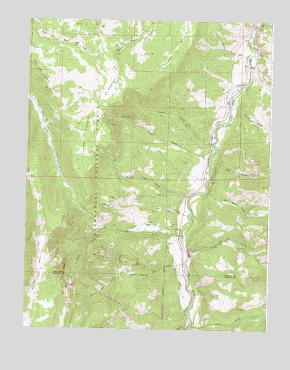
Alpine Plateau, CO USGS Topographic Map
Click on map above to begin viewing in our Map Viewer.

This topographic map contains these locations and features:
Feature Name Type Latitude Longitude GNIS ID View Map
Alpine CorralLocaleN38.2078°W107.3648°188482View Map
Alpine PlateauSummitN38.2201°W107.3481°188490View Map
BaldySummitN38.2478°W107.3484°188491View Map
Big Buck CreekStreamN38.1831°W107.2823°188489View Map
Big Willow ParkFlatN38.2222°W107.3339°188481View Map
Campbell CreekStreamN38.2011°W107.2789°188493View Map
Copeland Elk Creek DitchCanalN38.1517°W107.2987°188500View Map
Devils CreekStreamN38.1264°W107.2889°188487View Map
Dwyer GulchValleyN38.1967°W107.2797°188494View Map
Elk CreekStreamN38.1631°W107.2956°188484View Map
Ferrara Ranch MineMineN38.1347°W107.2714°1745644View Map
Fourth of July CreekStreamN38.1572°W107.2920°188488View Map
Hells CanyonValleyN38.1927°W107.2790°188495View Map
High Bridge GulchValleyN38.1254°W107.2918°188486View Map
Little Elk CreekStreamN38.1642°W107.3231°188483View Map
Narrow Grade CreekStreamN38.1786°W107.2917°188496View Map
Nurse - Brownlee CemeteryCemeteryN38.2355°W107.2675°2123878View Map
Ridge Stock DrivewayTrailN38.1306°W107.3728°203357View Map
Skunk CreekStreamN38.2147°W107.2709°188503View Map
Spring GulchValleyN38.2353°W107.2625°188480View Map
The GateGapN38.2481°W107.2587°188492View Map
Thomas RanchLocaleN38.2317°W107.2614°188478View Map
Thompson DitchCanalN38.1675°W107.3173°188498View Map
Thompson Ditch Number 2CanalN38.1667°W107.3278°188497View Map
Thompson RanchLocaleN38.1675°W107.3106°188501View Map
Trout CreekStreamN38.2319°W107.2617°188504View Map
Ute Trail RanchLocaleN38.1728°W107.2959°188502View Map
Well GulchValleyN38.1513°W107.2925°188485View Map
Whinnery RanchLocaleN38.1875°W107.2895°196678View Map
Wilson RanchLocaleN38.2369°W107.2676°188479View Map
Youman DitchCanalN38.1656°W107.3034°188499View Map

Note: Coordinates in the location and feature list above are referenced to NAD83 datum.


Copyright (C) 2008-2024 Ryan Niemi / Sunset Dynamics ... All Rights Reserved