TopoQuest Logo
Do you find TopoQuest useful?
Help keep TopoQuest running and adding new maps/features by donating!
Bitcoin:  19c7KJd3qBynnjoSw5npx9KScwjBe4ifkT
Litecoin:  LXs6TkuXGGXo1vDsWCkWVdjQX94eUKd6ui
Home View Maps Find Maps Find Places Resources & Links


Jacobs Reservoir, Utah Topographic Map

USGS Map Title: Jacobs Reservoir, UT
USGS Map MRC: 38111A5
DRG (GeoTIFF) Download: o38111a5.tif


Neighboring USGS Topographic Map Quads:


  Smooth Knoll, UT  
38111B6
 

  Government Point, UT  
38111B5
 

  Blind Lake, UT  
38111B4
 

  Big Lake, UT  
38111A6
 

  Jacobs Reservoir, UT  
38111A5
 

  Deer Creek Lake, UT  
38111A4
 

  Posy Lake, UT  
37111H6
 

  Roger Peak, UT  
37111H5
 

  Boulder Town, UT  
37111H4


Map MRC Location:

N39°
W112°
N39°
W111°
H8 H7 H6 H5 H4 H3 H2 H1
G8 G7 G6 G5 G4 G3 G2 G1
F8 F7 F6 F5 F4 F3 F2 F1
E8 E7 E6 E5 E4 E3 E2 E1
D8 D7 D6 D5 D4 D3 D2 D1
C8 C7 C6 C5 C4 C3 C2 C1
B8 B7 B6 B5 B4 B3 B2 B1
A8 A7 A6 A5 A4 A3 A2 A1
N38°
W112°
N38°
W111°

Jacobs Reservoir, UT USGS 1:24K Topographic Map Preview:
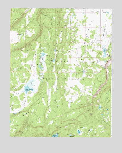
Jacobs Reservoir, UT USGS Topographic Map
Click on map above to begin viewing in our Map Viewer.

This topographic map contains these locations and features:
Feature Name Type Latitude Longitude GNIS ID View Map
Bakeskillet LakeLakeN38.1212°W111.5055°1425244View Map
Barney LakeLakeN38.0227°W111.6176°1425291View Map
Basin FlatsFlatN38.0325°W111.5674°1425315View Map
Bear LakeLakeN38.0292°W111.5147°1425353View Map
Black LakeLakeN38.0016°W111.5502°1425681View Map
Blue LakeLakeN38.0842°W111.5700°1425807View Map
Boulder MountainSummitN38.1250°W111.5007°1439025View Map
Boulder SwaleValleyN38.0264°W111.5785°1425897View Map
Broken DrawValleyN38.0880°W111.5102°1425990View Map
Burr TopSummitN38.0255°W111.5991°1439370View Map
Cuddyback LakeLakeN38.0070°W111.5255°1427150View Map
Dark Valley LakeLakeN38.0991°W111.6114°1427216View Map
Dark Valley ShelfBenchN38.1155°W111.5718°1427217View Map
Dry LakeLakeN38.0055°W111.5400°1427563View Map
Five LakesLakeN38.0637°W111.5347°1427973View Map
Four LakesLakeN38.0738°W111.5157°1428054View Map
Jacobs ReservoirReservoirN38.0490°W111.6007°1437886View Map
Jacobs ValleyValleyN38.0355°W111.6071°1429117View Map
Jacobs Valley DamDamN38.0417°W111.6057°1434657View Map
McGath LakeLakeN38.0005°W111.5695°1443253View Map
Purple LakeLakeN38.0743°W111.5714°1431503View Map
Riddle FlatFlatN38.1217°W111.5205°1437884View Map
Rim LakeLakeN38.0738°W111.5081°1431844View Map
Rock Spring RidgeRidgeN38.1167°W111.6152°1445103View Map
Row LakesLakeN38.0712°W111.5855°1432034View Map
Sawmill LakeLakeN38.0092°W111.5341°1432261View Map
South PointCapeN38.0292°W111.5521°1432747View Map
Spectacle LakeReservoirN38.0823°W111.5090°1434661View Map
Spectacle Lake DamDamN38.0783°W111.5074°1434662View Map
Squaw SpringSpringN38.0791°W111.5817°1432892View Map
Stairs SlopeSlopeN38.0880°W111.6107°1454913View Map
West Boulder DrawValleyN38.0880°W111.5102°1434050View Map

Note: Coordinates in the location and feature list above are referenced to NAD83 datum.


Copyright (C) 2008-2024 Ryan Niemi / Sunset Dynamics ... All Rights Reserved