TopoQuest Logo
Do you find TopoQuest useful?
Help keep TopoQuest running and adding new maps/features by donating!
Bitcoin:  19c7KJd3qBynnjoSw5npx9KScwjBe4ifkT
Litecoin:  LXs6TkuXGGXo1vDsWCkWVdjQX94eUKd6ui
Home View Maps Find Maps Find Places Resources & Links


Horner Mountain, Arizona Topographic Map

USGS Map Title: Horner Mountain, AZ
USGS Map MRC: 34111D7
DRG (GeoTIFF) Download: o34111d7.tif


Neighboring USGS Topographic Map Quads:


  Middle Verde, AZ  
34111E8
 

  Camp Verde, AZ  
34111E7
 

  Walker Mountain, AZ  
34111E6
 

  Arnold Mesa, AZ  
34111D8
 

  Horner Mountain, AZ  
34111D7
 

  Hackberry Mountain, AZ  
34111D6
 

  Dugas, AZ  
34111C8
 

  Tule Mesa, AZ  
34111C7
 

  Verde Hot Springs, AZ  
34111C6


Map MRC Location:

N35°
W112°
N35°
W111°
H8 H7 H6 H5 H4 H3 H2 H1
G8 G7 G6 G5 G4 G3 G2 G1
F8 F7 F6 F5 F4 F3 F2 F1
E8 E7 E6 E5 E4 E3 E2 E1
D8 D7 D6 D5 D4 D3 D2 D1
C8 C7 C6 C5 C4 C3 C2 C1
B8 B7 B6 B5 B4 B3 B2 B1
A8 A7 A6 A5 A4 A3 A2 A1
N34°
W112°
N34°
W111°

Horner Mountain, AZ USGS 1:24K Topographic Map Preview:
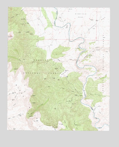
Horner Mountain, AZ USGS Topographic Map
Click on map above to begin viewing in our Map Viewer.

This topographic map contains these locations and features:
Feature Name Type Latitude Longitude GNIS ID View Map
Amerone Spring Number OneSpringN34.4758°W111.8493°25630View Map
Amerone Spring Number TwoSpringN34.4736°W111.8485°25631View Map
Bear Grass TankReservoirN34.4022°W111.7965°26091View Map
Bear Grass Tank Number TwoReservoirN34.3933°W111.7980°41057View Map
Bear SpringSpringN34.4266°W111.8117°26115View Map
Beasley FlatFlatN34.4811°W111.8018°26142View Map
Beasley Flat Recreation SiteLocaleN34.4722°W111.8011°2076115View Map
Billy TankReservoirN34.3971°W111.8158°26343View Map
Bootleg TankReservoirN34.3771°W111.8674°26614View Map
Boulder TankReservoirN34.3936°W111.7849°38267View Map
Brown SpringsSpringN34.4093°W111.7892°26789View Map
Brown Springs RanchLocaleN34.4111°W111.7871°26790View Map
Bull Run CreekStreamN34.4309°W111.7746°26969View Map
Bull Run RapidRapidsN34.4311°W111.7738°1852427View Map
Bushman RapidRapidsN34.4089°W111.7801°1852426View Map
Cedar BenchBenchN34.3811°W111.8043°27398View Map
Cedar Bench TankReservoirN34.3809°W111.8071°27401View Map
Cedar Bench WildernessReserveN34.4037°W111.8247°40988View Map
Cedar SpringSpringN34.3796°W111.8162°27437View Map
Chalk TankReservoirN34.3903°W111.8608°27492View Map
Chasm CorralLocaleN34.4472°W111.8218°41063View Map
Chasm CreekStreamN34.4464°W111.7899°27526View Map
Cold Water CreekStreamN34.3775°W111.7657°27803View Map
Cold Water TrailTrailN34.3870°W111.7929°27807View Map
Cold Water Trail Number Twenty SevenTrailN34.3803°W111.7924°38351View Map
Cottonwood BasinBasinN34.4850°W111.7635°27996View Map
Cottonwood CreekStreamN34.4686°W111.7829°40989View Map
Cottonwood SpringSpringN34.4876°W111.7707°28046View Map
Dripping SpringSpringN34.4456°W111.8035°41059View Map
Esperanza SpringSpringN34.4617°W111.8238°41062View Map
Gap CreekStreamN34.4145°W111.7818°29246View Map
Goat Camp SpringSpringN34.4370°W111.8676°29354View Map
Gospel HollowValleyN34.3923°W111.7685°29427View Map
Government SpringSpringN34.3897°W111.8488°29449View Map
Horner MountainSummitN34.4056°W111.8704°30115View Map
Horner Mountain TankReservoirN34.4120°W111.8694°30116View Map
Jims TankReservoirN34.4568°W111.7671°30545View Map
Laddens TankReservoirN34.4534°W111.7997°41064View Map
Ladder TankReservoirN34.4542°W111.8049°38558View Map
Lithograph SpringSpringN34.4634°W111.8627°38569View Map
Lower Cedar Bench CorralLocaleN34.3770°W111.7851°41058View Map
Lower Cedar Bench TankReservoirN34.3811°W111.7925°31342View Map
Lower Mine SpringSpringN34.4853°W111.8465°41067View Map
Mesa TankReservoirN34.4983°W111.8016°31734View Map
Mesquite SpringSpringN34.4870°W111.7682°31766View Map
Mesquite SpringSpringN34.3800°W111.7749°38622View Map
Mine SpringSpringN34.4842°W111.8526°31899View Map
Monkey TankReservoirN34.4372°W111.7950°2076225View Map
Mud SpringSpringN34.4200°W111.8263°41060View Map
North Mine SpringSpringN34.4880°W111.8544°32379View Map
Off-the-Wall RapidRapidsN34.4675°W111.7826°1852424View Map
Ox Bow Trail Number One Hundred Sixty ThreeTrailN34.3939°W111.8340°38678View Map
Oxbow TankReservoirN34.3842°W111.8403°32600View Map
Pre-Falls RapidRapidsN34.4620°W111.7876°1852423View Map
Punk RockIslandN34.4259°W111.7793°1853754View Map
Red Basin SpringSpringN34.4029°W111.8446°33426View Map
Red Blow SpringSpringN34.4114°W111.8401°41061View Map
Red Bluff SpringSpringN34.4097°W111.8449°33428View Map
Road TankReservoirN34.4298°W111.8037°33655View Map
Rodeo FlatFlatN34.4331°W111.8065°33773View Map
Rodeo Flat SpringSpringN34.4231°W111.8082°38762View Map
Rodeo Flat TankReservoirN34.4359°W111.8055°33774View Map
South Pasture TankReservoirN34.4049°W111.7984°34677View Map
Squaw Peak MineMineN34.4822°W111.8577°34782View Map
Sycamore CanyonValleyN34.4417°W111.7901°35025View Map
Sycamore TankReservoirN34.4510°W111.7762°35060View Map
Table MountainSummitN34.4275°W111.8315°35095View Map
Table Mountain SpringSpringN34.4377°W111.8179°35099View Map
Table Mountain TankReservoirN34.4282°W111.8172°35101View Map
The FallsFallsN34.4586°W111.7865°35221View Map
Towel CreekStreamN34.4139°W111.7813°35415View Map
Turkey Gobbler RapidRapidsN34.4261°W111.7790°1852420View Map
Verde TankReservoirN34.4456°W111.8040°38916View Map
Walnut SpringSpringN34.4745°W111.8628°35879View Map
White Flash RapidRapidsN34.3948°W111.7701°1852428View Map

Note: Coordinates in the location and feature list above are referenced to NAD83 datum.


Copyright (C) 2008-2024 Ryan Niemi / Sunset Dynamics ... All Rights Reserved