TopoQuest Logo
Do you find TopoQuest useful?
Help keep TopoQuest running and adding new maps/features by donating!
Bitcoin:  19c7KJd3qBynnjoSw5npx9KScwjBe4ifkT
Litecoin:  LXs6TkuXGGXo1vDsWCkWVdjQX94eUKd6ui
Home View Maps Find Maps Find Places Resources & Links


Candor, New York Topographic Map

USGS Map Title: Candor, NY
USGS Map MRC: 42076B3
DRG (GeoTIFF) Download: o42076b3.tif


Neighboring USGS Topographic Map Quads:


  Willseyville, NY  
42076C4
 

  Speedsville, NY  
42076C3
 

  Richford, NY  
42076C2
 

  Spencer, NY  
42076B4
 

  Candor, NY  
42076B3
 

  Newark Valley, NY  
42076B2
 

  Barton, NY  
42076A4
 

  Owego, NY  
42076A3
 

  Apalachin, NY  
42076A2


Map MRC Location:

N43°
W77°
N43°
W76°
H8 H7 H6 H5 H4 H3 H2 H1
G8 G7 G6 G5 G4 G3 G2 G1
F8 F7 F6 F5 F4 F3 F2 F1
E8 E7 E6 E5 E4 E3 E2 E1
D8 D7 D6 D5 D4 D3 D2 D1
C8 C7 C6 C5 C4 C3 C2 C1
B8 B7 B6 B5 B4 B3 B2 B1
A8 A7 A6 A5 A4 A3 A2 A1
N42°
W77°
N42°
W76°

Candor, NY USGS 1:24K Topographic Map Preview:
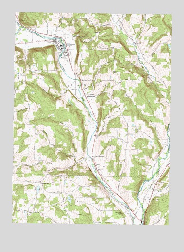
Candor, NY USGS Topographic Map
Click on map above to begin viewing in our Map Viewer.

This topographic map contains these locations and features:
Feature Name Type Latitude Longitude GNIS ID View Map
AA DairyLocaleN42.2356°W76.3622°2516989View Map
Allen Memorial Baptist ChurchChurchN42.2250°W76.3328°2507507View Map
Anderson Hill CemeteryCemeteryN42.1786°W76.2836°2061718View Map
Anderson Hill CemeteryCemeteryN42.1787°W76.2836°2507610View Map
Buttermilk FallsFallsN42.1317°W76.2879°945362View Map
CandorPopulated PlaceN42.2329°W76.3424°945764View Map
Candor Congregational ChurchChurchN42.2322°W76.3411°2507508View Map
Candor Elementary SchoolSchoolN42.2306°W76.3380°946282View Map
Candor Emergency SquadBuildingN42.2278°W76.3374°2719241View Map
Candor Fire DepartmentBuildingN42.2336°W76.3364°2700888View Map
Candor Free LibraryBuildingN42.2322°W76.3414°2507512View Map
Candor Health CenterHospitalN42.2275°W76.3372°2507666View Map
Candor HillSummitN42.2381°W76.3099°945765View Map
Candor Junior-Senior High SchoolSchoolN42.2290°W76.3374°946231View Map
CatatonkPopulated PlaceN42.1570°W76.3074°946032View Map
Catatonk Golf CourseLocaleN42.1831°W76.3125°2507665View Map
Cole BrookStreamN42.2304°W76.3349°947095View Map
Crimson Mobile Home CourtPopulated PlaceN42.2356°W76.3364°2507641View Map
Diamond PeakSummitN42.2154°W76.2972°948419View Map
East Branch Owego CreekStreamN42.1681°W76.2508°949011View Map
FairfieldPopulated PlaceN42.2326°W76.2785°972454View Map
Fallow Hollow Deer FarmLocaleN42.2008°W76.3336°2516993View Map
Fish Haven FarmLocaleN42.1769°W76.3111°2516994View Map
Germany HillPopulated PlaceN42.1490°W76.3524°972534View Map
Germany Hill CemeteryCemeteryN42.1493°W76.3526°2507531View Map
GridleyvillePopulated PlaceN42.2451°W76.3722°972572View Map
Hamar EstatesPopulated PlaceN42.1906°W76.3100°2507630View Map
Hamar Mobile Home EstatesPopulated PlaceN42.1906°W76.3102°2618231View Map
Hoyt CreekStreamN42.1629°W76.3122°953344View Map
Hubbard HillSummitN42.2076°W76.3663°953355View Map
Hubbard Hill BrookStreamN42.2106°W76.3277°953357View Map
HubbardtownPopulated PlaceN42.2015°W76.3183°953360View Map
Iron Kettle FarmLocaleN42.1939°W76.3108°2516995View Map
Jewell Mobile Home ParkPopulated PlaceN42.1906°W76.3125°2507639View Map
Kingdom Hall of Jehovah's WitnessesChurchN42.1725°W76.3108°2507509View Map
Klossner FarmsLocaleN42.1550°W76.3472°2516997View Map
Lane Collyer FieldParkN42.2333°W76.3461°2507667View Map
Lord Hill ChurchChurchN42.1734°W76.2635°2616675View Map
Maple Grove CemeteryCemeteryN42.2309°W76.3327°956404View Map
Owego HeightsPopulated PlaceN42.1483°W76.2944°2507633View Map
Owego Heights Mobile Home ParkPopulated PlaceN42.1480°W76.2948°2618263View Map
Pebble Hill Mobile Home ParkPopulated PlaceN42.1500°W76.2981°2507637View Map
Pine Tree Mobile Home ParkPopulated PlaceN42.1483°W76.2994°2507644View Map
Saint Francis ChurchChurchN42.1598°W76.3088°963492View Map
Saint Marks Episcopal ChurchChurchN42.2264°W76.3344°2507511View Map
Seventh Day Adventist ChurchChurchN42.1692°W76.3117°2507510View Map
Tioga CountyCivilN42.1703°W76.3063°974151View Map
Tioga Industrial ParkLocaleN42.1411°W76.2669°2507652View Map
Town of CandorCivilN42.2320°W76.3325°978786View Map
Turners BridgeBridgeN42.1267°W76.2702°967978View Map
Upper Fairfield CemeteryCemeteryN42.2366°W76.2835°2507611View Map
Village of CandorCivilN42.2284°W76.3366°2391578View Map
West Branch Owego CreekStreamN42.1684°W76.2508°969132View Map
Willseyville CreekStreamN42.2409°W76.3688°971392View Map
Woodbridge CemeteryCemeteryN42.1759°W76.3088°949746View Map
Zorn PondLakeN42.1451°W76.3543°971892View Map

Note: Coordinates in the location and feature list above are referenced to NAD83 datum.


Copyright (C) 2008-2024 Ryan Niemi / Sunset Dynamics ... All Rights Reserved