TopoQuest Logo
Do you find TopoQuest useful?
Help keep TopoQuest running and adding new maps/features by donating!
Bitcoin:  19c7KJd3qBynnjoSw5npx9KScwjBe4ifkT
Litecoin:  LXs6TkuXGGXo1vDsWCkWVdjQX94eUKd6ui
Home View Maps Find Maps Find Places Resources & Links


Alpine, Wyoming Topographic Map

USGS Map Title: Alpine, WY
USGS Map MRC: 43111B1
DRG (GeoTIFF) Download: o43111b1.tif


Neighboring USGS Topographic Map Quads:


  Palisades Dam, ID  
43111C2
 

  Mount Baird, ID  
43111C1
 

  Observation Peak, WY  
43110C8
 

  Poker Peak, ID  
43111B2
 

  Alpine, WY  
43111B1
 

  Ferry Peak, WY  
43110B8
 

  Tincup Mountain, ID  
43111A2
 

  Etna, WY  
43111A1
 

  Stewart Peak, WY  
43110A8


Map MRC Location:

N44°
W112°
N44°
W111°
H8 H7 H6 H5 H4 H3 H2 H1
G8 G7 G6 G5 G4 G3 G2 G1
F8 F7 F6 F5 F4 F3 F2 F1
E8 E7 E6 E5 E4 E3 E2 E1
D8 D7 D6 D5 D4 D3 D2 D1
C8 C7 C6 C5 C4 C3 C2 C1
B8 B7 B6 B5 B4 B3 B2 B1
A8 A7 A6 A5 A4 A3 A2 A1
N43°
W112°
N43°
W111°

Alpine, WY USGS 1:24K Topographic Map Preview:
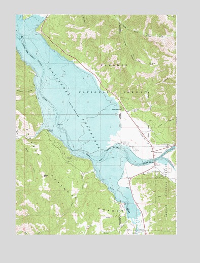
Alpine, WY USGS Topographic Map
Click on map above to begin viewing in our Map Viewer.

This topographic map contains these locations and features:
Feature Name Type Latitude Longitude GNIS ID View Map
AlpinePopulated PlaceN43.1635°W111.0180°1597727View Map
Alpine AirportAirportN43.1808°W111.0374°1608960View Map
Alpine CampgroundLocaleN43.1966°W111.0438°376567View Map
Alpine CampgroundLocaleN43.1963°W111.0433°1597728View Map
Alpine Fire DepartmentBuildingN43.1613°W111.0251°2673463View Map
Alpine Hot SpringsSpringN43.2369°W111.1091°399566View Map
Alpine JunctionPopulated PlaceN43.1724°W111.0185°1597729View Map
Alpine Northeast Census Designated PlaceCensusN43.1941°W111.0073°2407727View Map
Alpine Northwest Census Designated PlaceCensusN43.1804°W111.0332°2407728View Map
Alpine Post OfficePost OfficeN43.1633°W111.0194°2767903View Map
Alpine Post Office (historical)Post OfficeN43.1752°W111.0347°1926799View Map
Alpine Summer Home AreaLocaleN43.2021°W111.0410°1597572View Map
Bitters CreekStreamN43.1802°W111.1208°377712View Map
Bitters PeakSummitN43.1583°W111.1035°377713View Map
Burns CreekStreamN43.1416°W111.0408°378531View Map
Driveway CanyonValleyN43.2430°W111.0388°1599318View Map
Grand CanyonValleyN43.1744°W111.0010°1600014View Map
Grand Canyon Boat LandingLocaleN43.1763°W111.0435°1597573View Map
Grand ValleyValleyN43.2383°W111.1180°399165View Map
Greys RiverStreamN43.1685°W111.0127°1605135View Map
Hoffman CampgroundLocaleN43.1685°W111.0822°383235View Map
Indian CreekStreamN43.2466°W111.1044°383651View Map
Indian Creek Boat RampLocaleN43.2483°W111.1049°394146View Map
Jordan CanyonValleyN43.1841°W111.0202°1604408View Map
Little Box CanyonValleyN43.1816°W111.1230°384748View Map
Long Spring BasinBasinN43.2213°W111.0194°1601119View Map
Long Spring CanyonValleyN43.1955°W111.0438°1601120View Map
McCoy CreekStreamN43.1869°W111.1024°386589View Map
McCoy Creek CampgroundLocaleN43.1838°W111.1008°386590View Map
McNeel CreekStreamN43.1341°W111.0377°386659View Map
North Fork Trout CreekStreamN43.1349°W111.0908°394123View Map
Palisades ReservoirReservoirN43.2351°W111.1089°397973View Map
Salt RiverStreamN43.1657°W111.0632°389871View Map
Spencer Call Sand and Gravel PitMineN43.1777°W111.0341°1726242View Map
Spring RunStreamN43.2494°W111.1083°400106View Map
Town of AlpineCivilN43.1607°W111.0182°2412353View Map
Trout CreekStreamN43.1610°W111.0649°392414View Map
Williams CreekStreamN43.2083°W111.1108°393463View Map

Note: Coordinates in the location and feature list above are referenced to NAD83 datum.


Copyright (C) 2008-2024 Ryan Niemi / Sunset Dynamics ... All Rights Reserved