TopoQuest Logo
Do you find TopoQuest useful?
Help keep TopoQuest running and adding new maps/features by donating!
Bitcoin:  19c7KJd3qBynnjoSw5npx9KScwjBe4ifkT
Litecoin:  LXs6TkuXGGXo1vDsWCkWVdjQX94eUKd6ui
Home View Maps Find Maps Find Places Resources & Links


Caroga Lake, New York Topographic Map

USGS Map Title: Caroga Lake, NY
USGS Map MRC: 43074B4
DRG (GeoTIFF) Download: o43074b4.tif


Neighboring USGS Topographic Map Quads:


  Canada Lake, NY  
43074B5
 

  Caroga Lake, NY  
43074B4
 

  Jackson Summit, NY  
43074B3
 

  Lassellsville, NY  
43074A5
 

  Peck Lake, NY  
43074A4
 

  Gloversville, NY  
43074A3


Map MRC Location:

N44°
W75°
N44°
W74°
H8 H7 H6 H5 H4 H3 H2 H1
G8 G7 G6 G5 G4 G3 G2 G1
F8 F7 F6 F5 F4 F3 F2 F1
E8 E7 E6 E5 E4 E3 E2 E1
D8 D7 D6 D5 D4 D3 D2 D1
C8 C7 C6 C5 C4 C3 C2 C1
B8 B7 B6 B5 B4 B3 B2 B1
A8 A7 A6 A5 A4 A3 A2 A1
N43°
W75°
N43°
W74°

Caroga Lake, NY USGS 1:24K Topographic Map Preview:
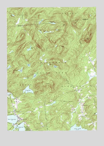
Caroga Lake, NY USGS Topographic Map
Click on map above to begin viewing in our Map Viewer.

This topographic map contains these locations and features:
Feature Name Type Latitude Longitude GNIS ID View Map
Bellows LakeLakeN43.1804°W74.4613°943624View Map
Bleecker CemeteryCemeteryN43.1521°W74.3954°2543440View Map
Bleecker CenterPopulated PlaceN43.1506°W74.3943°972241View Map
Brown LakeLakeN43.2420°W74.4908°944920View Map
CamelhumpSummitN43.1851°W74.4893°945520View Map
Caroga LakePopulated PlaceN43.1378°W74.4813°945874View Map
Caroga LakeLakeN43.1331°W74.4897°979704View Map
Caroga Lake Census Designated PlaceCensusN43.1352°W74.4810°2631638View Map
Caroga Lake Post OfficePost OfficeN43.1398°W74.4837°2617845View Map
Caroga Lake Volunteer Fire DepartmentBuildingN43.1591°W74.4870°2734980View Map
County Line LakeLakeN43.2339°W74.4353°947560View Map
Duck LakeLakeN43.2353°W74.4525°948741View Map
East Caroga LakeLakeN43.1281°W74.4807°949033View Map
Eastman LakeLakeN43.2078°W74.4686°949298View Map
Fisher Vly LakeLakeN43.2250°W74.4447°950162View Map
Five Point CemeteryCemeteryN43.1442°W74.4887°2543441View Map
Frie FlowStreamN43.1581°W74.4907°950729View Map
HogbackSummitN43.1723°W74.4490°952952View Map
Holmes LakeLakeN43.1899°W74.4322°953018View Map
Indian LakeLakeN43.1915°W74.4693°953669View Map
Irving PondReservoirN43.1660°W74.4707°953800View Map
Little Holmes LakeLakeN43.1922°W74.4416°955555View Map
Little Oxbarn LakeLakeN43.2269°W74.4298°955620View Map
Mead CreekStreamN43.1403°W74.4876°956860View Map
Mohawk Pathway CampLocaleN43.1323°W74.4526°957473View Map
Nick Stoner Golf CourseLocaleN43.1546°W74.4857°2615445View Map
Otter LakeLakeN43.1884°W74.4989°970437View Map
Panther MountainSummitN43.2328°W74.4043°959821View Map
Peters CornersPopulated PlaceN43.1659°W74.4021°960235View Map
Peters PondSwampN43.1806°W74.3832°960243View Map
Pigeon MountainSummitN43.2320°W74.4226°960380View Map
PinnacleSummitN43.2181°W74.3890°960599View Map
Pinnacle CreekStreamN43.1803°W74.3762°960602View Map
Prairie LakeLakeN43.1783°W74.4741°961087View Map
Saint Barbaras ChapelChurchN43.1442°W74.4874°963358View Map
Saint Johns Lutheran CemeteryCemeteryN43.1397°W74.3915°963614View Map
Saint Josephs CemeteryCemeteryN43.1543°W74.4132°963734View Map
School Number 4 (historical)SchoolN43.1433°W74.3953°2105865View Map
Shaker MountainSummitN43.2101°W74.4246°964919View Map
Stewart LakeLakeN43.1863°W74.4806°966407View Map
Town of BleeckerCivilN43.1735°W74.3831°978737View Map
Union SchoolSchoolN43.1551°W74.4868°968212View Map
West Caroga LakeLakeN43.1370°W74.4954°969167View Map
WheelervillePopulated PlaceN43.1573°W74.4868°971023View Map
Winter LakeLakeN43.2257°W74.4535°971510View Map

Note: Coordinates in the location and feature list above are referenced to NAD83 datum.


Copyright (C) 2008-2024 Ryan Niemi / Sunset Dynamics ... All Rights Reserved