TopoQuest Logo
Do you find TopoQuest useful?
Help keep TopoQuest running and adding new maps/features by donating!
Bitcoin:  19c7KJd3qBynnjoSw5npx9KScwjBe4ifkT
Litecoin:  LXs6TkuXGGXo1vDsWCkWVdjQX94eUKd6ui
Home View Maps Find Maps Find Places Resources & Links


Calabash, North Carolina Topographic Map

USGS Map Title: Calabash, NC
USGS Map MRC: 33078H5
DRG (GeoTIFF) Download: o33078h5.tif


Neighboring USGS Topographic Map Quads:


  Pireway, NC  
34078A6
 

  Freeland, NC  
34078A5
 

  Exum, NC  
34078A4
 

  Longs, SC  
33078H6
 

  Calabash, NC  
33078H5
 

  Shallotte, NC  
33078H4
 

  Wampee, SC  
33078G6
 

  Little River, SC  
33078G5


Map MRC Location:

N34°
W79°
N34°
W78°
H8 H7 H6 H5 H4 H3 H2 H1
G8 G7 G6 G5 G4 G3 G2 G1
F8 F7 F6 F5 F4 F3 F2 F1
E8 E7 E6 E5 E4 E3 E2 E1
D8 D7 D6 D5 D4 D3 D2 D1
C8 C7 C6 C5 C4 C3 C2 C1
B8 B7 B6 B5 B4 B3 B2 B1
A8 A7 A6 A5 A4 A3 A2 A1
N33°
W79°
N33°
W78°

Calabash, NC USGS 1:24K Topographic Map Preview:
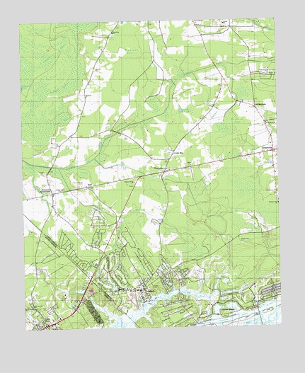
Calabash, NC USGS Topographic Map
Click on map above to begin viewing in our Map Viewer.

This topographic map contains these locations and features:
Feature Name Type Latitude Longitude GNIS ID View Map
Andrew ChapelChurchN33.9302°W78.6092°980184View Map
Bennett CemeteryCemeteryN33.9799°W78.5878°1004763View Map
Bethel ChurchChurchN33.9316°W78.6064°981107View Map
Bethel ChurchChurchN33.9577°W78.5050°1004761View Map
Beulah ChurchChurchN33.9335°W78.5925°981258View Map
Blane LandingLocaleN33.8793°W78.5272°1004630View Map
Blanes Landing (historical)LocaleN33.8788°W78.5272°1004819View Map
Blanton CemeteryCemeteryN33.9391°W78.6145°1004757View Map
Bonaparte LandingLocaleN33.8768°W78.5403°1024884View Map
Boundary CreekStreamN33.8816°W78.5792°981762View Map
CalabashPopulated PlaceN33.8907°W78.5683°1019469View Map
Calabash CreekStreamN33.8774°W78.5753°1221194View Map
Calabash Fire Department Station 12 - 1 HeadquartersBuildingN33.8928°W78.5664°2638280View Map
Calabash Fire Department Station 12 - 2BuildingN33.9537°W78.5752°2638634View Map
Calabash Post OfficePost OfficeN33.8913°W78.5749°2505341View Map
Calabash RiverStreamN33.8774°W78.5758°1027385View Map
Calabash Volunteer Emergency Medical ServicesBuildingN33.8981°W78.5536°2720660View Map
Carolina ShoresPopulated PlaceN33.9010°W78.5806°1802948View Map
Carolina Shores Golf and Country ClubLocaleN33.8977°W78.5837°2489990View Map
Cawcaw BridgesBridgeN33.9404°W78.6108°982783View Map
Cedar BayPopulated PlaceN33.9457°W78.5483°1019568View Map
Corkins NeckCapeN33.8780°W78.5553°1008262View Map
Cypress Bay Golf CourseLocaleN33.8793°W78.6222°1243683View Map
Doghead BaySwampN33.9591°W78.5195°984257View Map
Drowned BaySwampN33.9210°W78.5172°984336View Map
Earnest BranchStreamN33.9568°W78.6158°984478View Map
First Apostolic ChurchChurchN33.8843°W78.6206°1004764View Map
Friendship ChurchChurchN33.9952°W78.5786°1004762View Map
Greenbriar LakeReservoirN33.8902°W78.5797°1238789View Map
GrissettownPopulated PlaceN33.9466°W78.5022°1020568View Map
Grissettown - Longwood Fire and RescueBuildingN33.9667°W78.5165°2638759View Map
Heather Glen Golf CourseLocaleN33.8893°W78.6050°1243762View Map
Hickmans BranchStreamN33.9407°W78.6197°986684View Map
Hickmans CrossroadsPopulated PlaceN33.9304°W78.6103°1020699View Map
IredellPopulated PlaceN33.9332°W78.5911°1020893View Map
Iredell BridgeBridgeN33.9318°W78.6014°987395View Map
Jinks Landing (historical)LocaleN33.8855°W78.5025°1004822View Map
La Savannah School (historical)SchoolN33.9443°W78.5528°1004824View Map
Lewis CemeteryCemeteryN33.8993°W78.6172°1004765View Map
Little Cawcaw SwampStreamN33.9402°W78.5839°988566View Map
Little River Medical CenterHospitalN33.8832°W78.5986°1247977View Map
Little River School (historical)SchoolN33.8788°W78.6158°1243811View Map
Little River United Methodist ChurchChurchN33.8771°W78.6136°1243812View Map
Little River Village Shopping CenterLocaleN33.8791°W78.6111°1243813View Map
Manley Bennett CemeteryCemeteryN33.9343°W78.5958°1004756View Map
Marys Landing (historical)LocaleN33.8818°W78.5114°1004827View Map
Milliken CoveBayN33.8760°W78.5728°1227853View Map
Mullet CreekStreamN33.8785°W78.5797°1249762View Map
Old ShallotteLocaleN33.9649°W78.5103°991605View Map
Oyster Bay Golf LinksLocaleN33.8841°W78.5266°2490036View Map
Pearl Golf LinksLocaleN33.8962°W78.5361°2490043View Map
Persimmon SwampStreamN33.9202°W78.5767°992068View Map
Pleasant Grove ChurchChurchN33.9346°W78.5697°992462View Map
Pleasant View CemeteryCemeteryN33.9093°W78.5178°1004759View Map
Pleasant View ChurchChurchN33.9252°W78.5003°1004828View Map
Saint Andrew ChurchChurchN33.8907°W78.5670°993858View Map
Sea Trail Golf LinksLocaleN33.8895°W78.5133°2490057View Map
Shady ForestPopulated PlaceN33.8880°W78.5503°1005423View Map
Shingletree Bridges (historical)BridgeN33.9204°W78.5795°1004831View Map
Shingletree SwampStreamN33.9418°W78.6172°994729View Map
Smith BridgesBridgeN33.9549°W78.5797°994935View Map
South Carolina Noname 26020 D-3623 DamDamN33.8902°W78.5797°1238788View Map
Stanland BaySwampN33.9849°W78.5689°995406View Map
Stanland BranchStreamN33.9638°W78.6186°995407View Map
Sunset BeachPopulated PlaceN33.8807°W78.5122°1004755View Map
Sunset Beach Fire DepartmentBuildingN33.8838°W78.5118°2638829View Map
Sunset Beach Post Office (historical)Post OfficeN33.8807°W78.5122°1940256View Map
The Big NarrowsChannelN33.8785°W78.5058°995958View Map
Thomas BaySwampN33.9388°W78.5900°996026View Map
ThomasboroPopulated PlaceN33.9388°W78.5553°1022939View Map
Town of CalabashCivilN33.8945°W78.5571°2405358View Map
Town of Carolina ShoresCivilN33.9076°W78.5738°2405382View Map
Town of Sunset BeachCivilN33.8921°W78.5103°2406693View Map
United ChurchChurchN33.9985°W78.5247°1004760View Map
Wesleyan ChurchChurchN33.9691°W78.5931°1024900View Map
Wilson CemeteryCemeteryN33.8918°W78.5614°1004758View Map

Note: Coordinates in the location and feature list above are referenced to NAD83 datum.


Copyright (C) 2008-2024 Ryan Niemi / Sunset Dynamics ... All Rights Reserved