TopoQuest Logo
Do you find TopoQuest useful?
Help keep TopoQuest running and adding new maps/features by donating!
Bitcoin:  19c7KJd3qBynnjoSw5npx9KScwjBe4ifkT
Litecoin:  LXs6TkuXGGXo1vDsWCkWVdjQX94eUKd6ui
Home View Maps Find Maps Find Places Resources & Links


Burkburnett, Texas Topographic Map

USGS Map Title: Burkburnett, TX
USGS Map MRC: 34098A5
DRG (GeoTIFF) Download: o34098a5.tif


Neighboring USGS Topographic Map Quads:


  Grandfield, OK  
34098B6
 

  Devol, OK  
34098B5
 

  Randlett, OK  
34098B4
 

  Clara, TX  
34098A6
 

  Burkburnett, TX  
34098A5
 

  Thornberry, TX  
34098A4
 

  Iowa Park, TX  
33098H6
 

  Wichita Falls West, TX  
33098H5
 

  Wichita Falls East, TX  
33098H4


Map MRC Location:

N35°
W99°
N35°
W98°
H8 H7 H6 H5 H4 H3 H2 H1
G8 G7 G6 G5 G4 G3 G2 G1
F8 F7 F6 F5 F4 F3 F2 F1
E8 E7 E6 E5 E4 E3 E2 E1
D8 D7 D6 D5 D4 D3 D2 D1
C8 C7 C6 C5 C4 C3 C2 C1
B8 B7 B6 B5 B4 B3 B2 B1
A8 A7 A6 A5 A4 A3 A2 A1
N34°
W99°
N34°
W98°

Burkburnett, TX USGS 1:24K Topographic Map Preview:
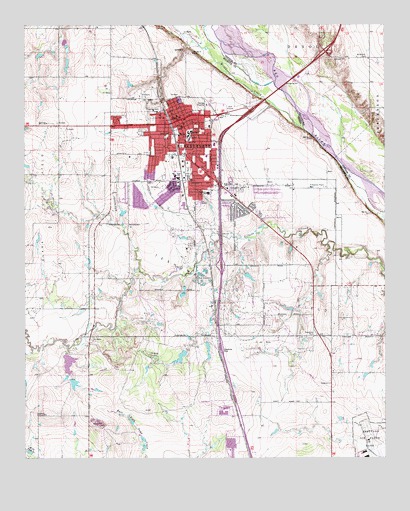
Burkburnett, TX USGS Topographic Map
Click on map above to begin viewing in our Map Viewer.

This topographic map contains these locations and features:
Feature Name Type Latitude Longitude GNIS ID View Map
Apostolic Faith United Pentecostal ChurchChurchN34.0965°W98.5751°2024962View Map
Barbour-Kitchell LakeReservoirN34.0301°W98.6087°1856257View Map
Barbour-Kitchell Lake DamDamN34.0301°W98.6087°1856256View Map
Bulldog StadiumParkN34.0812°W98.5773°2027950View Map
BurkburnettPopulated PlaceN34.0979°W98.5706°1353321View Map
Burkburnett Alternative Education CenterSchoolN34.0879°W98.5723°2009489View Map
Burkburnett Church of ChristChurchN34.0948°W98.5706°2025043View Map
Burkburnett Church of GodChurchN34.0954°W98.5681°2025054View Map
Burkburnett City HallBuildingN34.0878°W98.5687°2753377View Map
Burkburnett DivisionCivilN34.0933°W98.6094°1938580View Map
Burkburnett Fire Department Station 1BuildingN34.0980°W98.5730°2551881View Map
Burkburnett Fire Department Station 3BuildingN34.0813°W98.5687°2551956View Map
Burkburnett High SchoolSchoolN34.0804°W98.5709°2009490View Map
Burkburnett Junior High SchoolSchoolN34.0934°W98.5698°2009491View Map
Burkburnett Police DepartmentBuildingN34.0981°W98.5728°2750229View Map
Burkburnett Post OfficePost OfficeN34.0873°W98.5727°2731133View Map
Cashion City HallBuildingN34.0400°W98.5136°2753309View Map
Cashion CommunityPopulated PlaceN34.0357°W98.5001°1922766View Map
Central Church of Christ of BurkburnettChurchN34.0801°W98.5889°2025044View Map
Church of the NazareneChurchN34.0898°W98.5787°2025063View Map
City of BurkburnettCivilN34.0748°W98.5671°2409941View Map
City of Cashion CommunityCivilN34.0364°W98.5082°2409404View Map
Crumpler LakeReservoirN34.0284°W98.6104°1864849View Map
Crumpler Lake DamDamN34.0301°W98.6103°1864848View Map
First Assembly of God of Burkburnett ChurchChurchN34.0934°W98.5681°2024278View Map
First United Methodist Church of BurkburnettChurchN34.0990°W98.5717°2025018View Map
Freeman ParkParkN34.1004°W98.5787°1357719View Map
Friberg - Cooper Fire DepartmentBuildingN34.0248°W98.5142°2551166View Map
Grace Lutheran Church of BurkburnettChurchN34.0965°W98.5687°2025013View Map
Hardin SchoolSchoolN34.0940°W98.5684°1358770View Map
I C Evans Elementary SchoolSchoolN34.0795°W98.5612°2009451View Map
Janlee Baptist ChurchChurchN34.0798°W98.5717°2025080View Map
Permian ParkParkN34.0820°W98.5681°1365070View Map
Preston LakeReservoirN34.0295°W98.5708°1856253View Map
Preston Lake DamDamN34.0301°W98.5703°1856252View Map
Saint John the Divine Episcopal Church of BurkburnettChurchN34.0795°W98.5606°2025065View Map
Saint Jude Catholic ChurchChurchN34.0862°W98.5695°2025042View Map
Southside SchoolSchoolN34.0768°W98.5614°1368845View Map
Texhoma Oil FieldOilfieldN34.0465°W98.5401°1369761View Map
Wichita County Constable's Office Precinct 2BuildingN34.0829°W98.5801°2750787View Map
Wildhorse CreekStreamN34.0906°W98.5220°1371530View Map
Wildhorse CreekStreamN34.0906°W98.5217°1099784View Map
Wilkerson CemeteryCemeteryN34.1157°W98.5065°1099812View Map

Note: Coordinates in the location and feature list above are referenced to NAD83 datum.


Copyright (C) 2008-2024 Ryan Niemi / Sunset Dynamics ... All Rights Reserved