TopoQuest Logo
Do you find TopoQuest useful?
Help keep TopoQuest running and adding new maps/features by donating!
Bitcoin:  19c7KJd3qBynnjoSw5npx9KScwjBe4ifkT
Litecoin:  LXs6TkuXGGXo1vDsWCkWVdjQX94eUKd6ui
Home View Maps Find Maps Find Places Resources & Links


Allensville, Pennsylvania Topographic Map

USGS Map Title: Allensville, PA
USGS Map MRC: 40077E7
DRG (GeoTIFF) Download: o40077e7.tif


Neighboring USGS Topographic Map Quads:


  Pine Grove Mills, PA  
40077F8
 

  McAlevys Fort, PA  
40077F7
 

  Barrville, PA  
40077F6
 

  Donation, PA  
40077E8
 

  Allensville, PA  
40077E7
 

  Belleville, PA  
40077E6
 

  Mount Union, PA  
40077D8
 

  Newton Hamilton, PA  
40077D7
 

  McVeytown, PA  
40077D6


Map MRC Location:

N41°
W78°
N41°
W77°
H8 H7 H6 H5 H4 H3 H2 H1
G8 G7 G6 G5 G4 G3 G2 G1
F8 F7 F6 F5 F4 F3 F2 F1
E8 E7 E6 E5 E4 E3 E2 E1
D8 D7 D6 D5 D4 D3 D2 D1
C8 C7 C6 C5 C4 C3 C2 C1
B8 B7 B6 B5 B4 B3 B2 B1
A8 A7 A6 A5 A4 A3 A2 A1
N40°
W78°
N40°
W77°

Allensville, PA USGS 1:24K Topographic Map Preview:
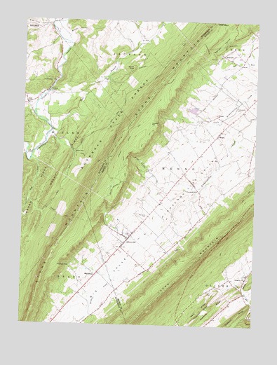
Allensville, PA USGS Topographic Map
Click on map above to begin viewing in our Map Viewer.

This topographic map contains these locations and features:
Feature Name Type Latitude Longitude GNIS ID View Map
AllensvillePopulated PlaceN40.5359°W77.8169°1168200View Map
Allensville Census Designated PlaceCensusN40.5330°W77.8142°2584433View Map
Allensville Post OfficePost OfficeN40.5335°W77.8193°2773060View Map
Allensville Post Office (historical)Post OfficeN40.5342°W77.8197°1214535View Map
Allensville Volunteer Fire Department Station 25BuildingN40.5346°W77.8188°2645817View Map
Bald RidgeRidgeN40.5065°W77.7778°1168649View Map
Bearpen HollowValleyN40.6113°W77.7718°1168969View Map
Big ValleyValleyN40.5004°W77.8439°1192143View Map
Blue Lick HollowValleyN40.6237°W77.8607°1169887View Map
Brush RidgeRidgeN40.5556°W77.8653°1170446View Map
Carbon TrailTrailN40.5445°W77.8539°1171192View Map
Chipp TrailTrailN40.5645°W77.8197°1171793View Map
Concord School (historical)SchoolN40.5179°W77.8372°1197831View Map
Copeland Spring TrailTrailN40.5740°W77.8189°1172439View Map
Detweiler CemeteryCemeteryN40.5205°W77.8407°1958417View Map
Dry RunStreamN40.5684°W77.8706°1173545View Map
Dunmire RidgeRidgeN40.5076°W77.7705°1173617View Map
East Branch Standing Stone CreekStreamN40.5801°W77.8592°1198061View Map
Eleven Springs TrailTrailN40.5559°W77.8256°1174093View Map
Fleming Poultry FarmLocaleN40.5631°W77.7589°2725560View Map
Garret KnobSummitN40.6056°W77.8150°1175461View Map
Geisler RunStreamN40.5815°W77.8606°1212136View Map
Herod RunStreamN40.6240°W77.8589°1192604View Map
Hostetler GapGapN40.5840°W77.8022°1177490View Map
Hostetler TrailTrailN40.6045°W77.7914°1177491View Map
Huey Airport (historical)AirportN40.5834°W77.8164°1194031View Map
Jackson CornerPopulated PlaceN40.5965°W77.8619°1177917View Map
King SchoolSchoolN40.5612°W77.7914°1197199View Map
Kings HollowValleyN40.5618°W77.8047°1178493View Map
Martin GapGapN40.5720°W77.8483°1180488View Map
Martin Gap CCC CampLocaleN40.5717°W77.8486°1197832View Map
Martin TrailTrailN40.5653°W77.8375°1180497View Map
MennoPopulated PlaceN40.5784°W77.7700°1180928View Map
Mennonite CemeteryCemeteryN40.5451°W77.8069°1180930View Map
Murphy HollowValleyN40.6195°W77.8500°1182103View Map
Prayer RockSummitN40.5445°W77.7564°1202157View Map
RockvillePopulated PlaceN40.6112°W77.7675°1185330View Map
Rockville TrailTrailN40.6115°W77.7767°1185337View Map
Rocky RidgeRidgeN40.5673°W77.8514°1185361View Map
Sample SchoolSchoolN40.6112°W77.7556°1197201View Map
School Number 6SchoolN40.5237°W77.7555°1197829View Map
SharpsburgPopulated PlaceN40.5204°W77.8344°1204628View Map
Spring RunStreamN40.5156°W77.7547°1188271View Map
Spring Run ChurchChurchN40.5192°W77.7539°1188276View Map
Spruce RunStreamN40.5695°W77.8736°1193425View Map
Stone MountainSummitN40.5487°W77.8428°1193474View Map
Swarey SpringSpringN40.5631°W77.7739°1202318View Map
Township of MennoCivilN40.5591°W77.7894°1216830View Map
Township of MillerCivilN40.5755°W77.8713°1216514View Map
Waynesburg SchoolSchoolN40.5554°W77.7806°1190725View Map
Wesley ChapelChurchN40.5906°W77.8728°1190856View Map
Westover PondLakeN40.5241°W77.8486°1191178View Map
Whitehall SchoolSchoolN40.5834°W77.7644°1197200View Map
Whitehall SchoolSchoolN40.5867°W77.7708°1191325View Map

Note: Coordinates in the location and feature list above are referenced to NAD83 datum.


Copyright (C) 2008-2024 Ryan Niemi / Sunset Dynamics ... All Rights Reserved