TopoQuest Logo
Do you find TopoQuest useful?
Help keep TopoQuest running and adding new maps/features by donating!
Bitcoin:  19c7KJd3qBynnjoSw5npx9KScwjBe4ifkT
Litecoin:  LXs6TkuXGGXo1vDsWCkWVdjQX94eUKd6ui
Home View Maps Find Maps Find Places Resources & Links


Bryson City, North Carolina Topographic Map

USGS Map Title: Bryson City, NC
USGS Map MRC: 35083D4
DRG (GeoTIFF) Download: o35083d4.tif


Neighboring USGS Topographic Map Quads:


  Silers Bald, NC  
35083E5
 

  Clingmans Dome, NC  
35083E4
 

  Smokemont, NC  
35083E3
 

  Noland Creek, NC  
35083D5
 

  Bryson City, NC  
35083D4
 

  Whittier, NC  
35083D3
 

  Wesser, NC  
35083C5
 

  Alarka, NC  
35083C4
 

  Greens Creek, NC  
35083C3


Map MRC Location:

N36°
W84°
N36°
W83°
H8 H7 H6 H5 H4 H3 H2 H1
G8 G7 G6 G5 G4 G3 G2 G1
F8 F7 F6 F5 F4 F3 F2 F1
E8 E7 E6 E5 E4 E3 E2 E1
D8 D7 D6 D5 D4 D3 D2 D1
C8 C7 C6 C5 C4 C3 C2 C1
B8 B7 B6 B5 B4 B3 B2 B1
A8 A7 A6 A5 A4 A3 A2 A1
N35°
W84°
N35°
W83°

Bryson City, NC USGS 1:24K Topographic Map Preview:
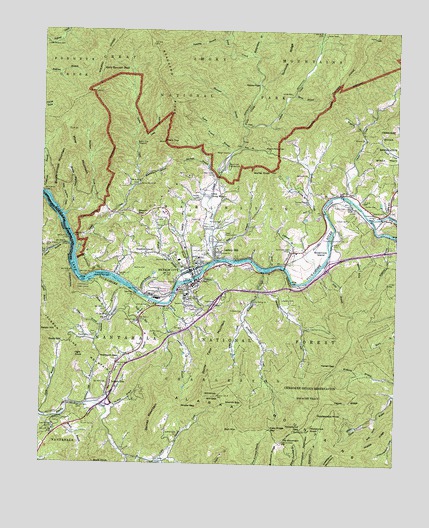
Bryson City, NC USGS Topographic Map
Click on map above to begin viewing in our Map Viewer.

This topographic map contains these locations and features:
Feature Name Type Latitude Longitude GNIS ID View Map
Antioch ChurchChurchN35.4690°W83.3865°1008747View Map
Arlington ChurchChurchN35.4140°W83.4493°1008767View Map
Baines MountainSummitN35.3939°W83.4564°1018905View Map
Battle CoveValleyN35.4350°W83.3884°1008958View Map
Beaugard RidgeRidgeN35.4966°W83.4619°1009067View Map
Betts BranchStreamN35.4370°W83.4399°1009235View Map
Blankenship CemeteryCemeteryN35.4115°W83.4810°1009468View Map
Bryson BranchStreamN35.4276°W83.4515°1009712View Map
Bryson CityPopulated PlaceN35.4309°W83.4474°1019348View Map
Bryson City DamDamN35.4668°W83.4663°1017208View Map
Bryson City Fire DepartmentBuildingN35.4269°W83.4455°2639489View Map
Bryson City Police DepartmentBuildingN35.4273°W83.4448°2769788View Map
Bryson City Post OfficePost OfficeN35.4288°W83.4493°2766580View Map
Bryson City ReservoirReservoirN35.4649°W83.4674°1009716View Map
Buckhorn RidgeRidgeN35.3813°W83.4144°1009778View Map
Buckner BranchStreamN35.4262°W83.4715°1009781View Map
Bumgardner BranchStreamN35.4929°W83.4263°1009810View Map
Buzzardroost MountainSummitN35.4661°W83.4926°1019458View Map
Camp Living WaterLocaleN35.4520°W83.4413°1009970View Map
Cherokee Indian Reservation 3200 Acre TractCivilN35.4126°W83.3915°1018066View Map
Cochran BranchStreamN35.4223°W83.4618°1010349View Map
Cold Springs ChurchChurchN35.3848°W83.4949°1010389View Map
Cooper CemeteryCemeteryN35.4459°W83.3921°1010472View Map
Cooper CreekStreamN35.4526°W83.3927°1010473View Map
Cowstamp MountainSummitN35.3773°W83.3961°1019825View Map
Cripple CreekStreamN35.4268°W83.4493°1010584View Map
Dancing BranchStreamN35.4973°W83.4368°1010643View Map
Davis GapGapN35.4098°W83.4915°1010695View Map
De Hart BranchStreamN35.3923°W83.4777°1010704View Map
De Hart CemeteryCemeteryN35.3973°W83.4765°1010705View Map
De Hart MillPopulated PlaceN35.3918°W83.4874°1010706View Map
Deep CreekStreamN35.4337°W83.4388°1010726View Map
Deep Creek CampgroundLocaleN35.4603°W83.4347°1010727View Map
Deep Creek CemeteryCemeteryN35.4587°W83.4396°1010728View Map
Deep Creek ChurchChurchN35.4429°W83.4399°1010729View Map
Deep Creek Group CampLocaleN35.4630°W83.4348°2775213View Map
Dog CoveValleyN35.3887°W83.3804°1010854View Map
Durham BranchStreamN35.4593°W83.4379°1010949View Map
East Alarka ChurchChurchN35.3757°W83.4588°1010970View Map
Easy Ridge GapGapN35.3851°W83.4188°1011009View Map
ElaPopulated PlaceN35.4495°W83.3907°1011035View Map
Estes CemeteryCemeteryN35.4451°W83.4471°1011105View Map
Falls BranchStreamN35.4298°W83.4029°1011168View Map
Ferguson Field Municipal (historical)AirportN35.4398°W83.4027°1016915View Map
Fishtrap BranchStreamN35.4418°W83.3785°1011238View Map
Franklin GrovePopulated PlaceN35.4357°W83.4629°1020353View Map
Frisbee BranchStreamN35.3918°W83.4799°1011397View Map
Fry MountainSummitN35.3815°W83.4142°1011407View Map
Frye Mountain LookoutLocaleN35.3815°W83.4143°1018040View Map
Galbraith CemeteryCemeteryN35.4584°W83.4065°1011425View Map
Galbraith ChurchChurchN35.4579°W83.4068°1018041View Map
Galbraith CreekStreamN35.4473°W83.3996°1011426View Map
Gibby BranchStreamN35.4145°W83.4788°1011480View Map
Governors IslandIslandN35.4382°W83.3985°1011579View Map
Governors Island ChurchChurchN35.4373°W83.4121°1011580View Map
Hammer BranchStreamN35.4732°W83.4302°1011818View Map
Hammer Branch CemeteryCemeteryN35.4788°W83.4372°2775247View Map
Hayes RidgeRidgeN35.3930°W83.3988°1011927View Map
Hickorynut GapGapN35.3851°W83.4079°1012020View Map
Hickorynut KnobSummitN35.3851°W83.4046°1020719View Map
Hickorynut MountainRidgeN35.3834°W83.4045°1012023View Map
Hillside ChurchChurchN35.4254°W83.4482°1012076View Map
Holly Spring ChurchChurchN35.4218°W83.4252°1012142View Map
Hughes BranchStreamN35.4209°W83.4552°1012256View Map
Indian CreekStreamN35.4723°W83.4290°1012337View Map
Jackson LinePopulated PlaceN35.3982°W83.4749°1020924View Map
Jenkins BranchStreamN35.4207°W83.4563°1012449View Map
Jenkins CemeteryCemeteryN35.3834°W83.4518°1012452View Map
Jenkins CemeteryCemeteryN35.4129°W83.4571°1012454View Map
Jenkins CemeteryCemeteryN35.4204°W83.4618°1012455View Map
Jenkins PlacePopulated PlaceN35.4851°W83.4240°1020944View Map
Johnson BranchStreamN35.4318°W83.4138°1012521View Map
Juney Whank BranchStreamN35.4643°W83.4338°1012586View Map
Kelly Bennett PeakSummitN35.4883°W83.4792°1021025View Map
Kirkland CemeteryCemeteryN35.4190°W83.4290°1012639View Map
Kirkland CreekStreamN35.4304°W83.4215°1012640View Map
Lackey HillPopulated PlaceN35.4370°W83.4385°1021073View Map
Lands CreekStreamN35.4357°W83.4877°1012675View Map
Laney CemeteryCemeteryN35.4821°W83.4124°1012679View Map
Laurel BranchStreamN35.4382°W83.4899°1012714View Map
Laurel Branch CemeteryCemeteryN35.4373°W83.4988°1012718View Map
Lemmons BranchStreamN35.4237°W83.4649°1012820View Map
Little Alarka CreekStreamN35.3770°W83.4685°1012899View Map
Little Peachtree CreekStreamN35.4470°W83.4929°1012998View Map
Long BranchStreamN35.4670°W83.4668°1013113View Map
Maple BranchStreamN35.4318°W83.4190°1013307View Map
McHan CemeteryCemeteryN35.4498°W83.3824°1013428View Map
Messer BranchStreamN35.4179°W83.4752°1013475View Map
Middle Peachtree CreekStreamN35.4476°W83.4902°1013508View Map
Middle RidgeRidgeN35.3783°W83.3859°1013520View Map
Milksick CoveValleyN35.4307°W83.4894°1013533View Map
Mine MountainSummitN35.4713°W83.4907°1021487View Map
Morning Star ChurchChurchN35.4343°W83.4543°1013702View Map
Morrow CemeteryCemeteryN35.4445°W83.4374°1013709View Map
Mount Carmel ChurchChurchN35.4170°W83.4760°1013731View Map
Mountain BranchStreamN35.4334°W83.4874°1013792View Map
Oconaluftee RiverStreamN35.4462°W83.3838°1014073View Map
Odear CoveValleyN35.3864°W83.3870°1014075View Map
Ogle KnobSummitN35.4059°W83.4882°1021723View Map
Parkview ChurchChurchN35.4357°W83.4379°1014234View Map
Peachtree CreekStreamN35.4462°W83.4918°1014286View Map
Queen - Lower Indian Creek CemeteryCemeteryN35.4991°W83.4007°1014683View Map
Queen BranchStreamN35.4818°W83.4115°1014681View Map
Randall CemeteryCemeteryN35.4515°W83.4449°1014730View Map
Rattlesnake KnobSummitN35.3889°W83.4022°1022158View Map
Rich MountainSummitN35.3848°W83.4296°1022264View Map
Robinson BranchStreamN35.3920°W83.4829°1014969View Map
Robinson GapGapN35.4057°W83.4790°1014979View Map
Rock Creek ChurchChurchN35.4451°W83.4596°1014994View Map
Rocky Face MountainSummitN35.3944°W83.4425°1022344View Map
Saint Joseph ChurchChurchN35.4282°W83.4429°1015159View Map
Scarred BranchStreamN35.4340°W83.4254°1015317View Map
Sharp TopSummitN35.4678°W83.4575°1015389View Map
Shepherd CreekStreamN35.4257°W83.4229°1015423View Map
Sherrill CemeteryCemeteryN35.4479°W83.3796°1015426View Map
Sherrill GapGapN35.3923°W83.4340°1015428View Map
Sherrill GapGapN35.4465°W83.4660°1015429View Map
Shuler GapGapN35.3915°W83.4496°1015500View Map
Silvermine BranchStreamN35.4562°W83.4654°1015528View Map
Sitton CreekStreamN35.4168°W83.4288°1015556View Map
Sossamon FieldAirportN35.4270°W83.4602°1016913View Map
Spruce Grove ChurchChurchN35.4554°W83.4654°1015756View Map
Sutton CemeteryCemeteryN35.4501°W83.3968°1015965View Map
Swain Community HospitalHospitalN35.4345°W83.4448°2701538View Map
Swain CountyCivilN35.4868°W83.4927°1008588View Map
Swain County Emergency Medical ServicesBuildingN35.4293°W83.4506°2720665View Map
Swain County High SchoolSchoolN35.4237°W83.4488°1015970View Map
Swain County Rescue SquadBuildingN35.4298°W83.4495°2720650View Map
Swain County Sheriff's OfficeBuildingN35.4171°W83.4532°2769696View Map
Swain Memorial CemeteryCemeteryN35.4409°W83.4368°1015972View Map
Terrell GapGapN35.4040°W83.3952°1016074View Map
Thomas ChapelChurchN35.4507°W83.4065°1016109View Map
Tom BranchStreamN35.4668°W83.4302°1016175View Map
Toot Hollow BranchStreamN35.4279°W83.4485°1016194View Map
Town of Bryson CityCivilN35.4262°W83.4474°2405339View Map
Tuckasegee DockLocaleN35.4295°W83.4757°1016247View Map
Upper Noland - Branton CemeteryCemeteryN35.4962°W83.4991°1016344View Map
Valley Village Shopping CenterLocaleN35.4268°W83.4471°1017840View Map
Victory ChurchChurchN35.4440°W83.4554°1016374View Map
Watkins BranchStreamN35.4290°W83.4740°1016470View Map
Watkins CemeteryCemeteryN35.4226°W83.4149°1016472View Map
Watkins CemeteryCemeteryN35.4312°W83.4677°1016473View Map
WBHN-AM (Bryson City)TowerN35.4282°W83.4382°1018447View Map
Welch BranchStreamN35.3887°W83.4924°1016498View Map
Wiggins - Watson CemeteryCemeteryN35.4659°W83.4204°1016655View Map
Wiggins BranchStreamN35.4718°W83.3874°1016648View Map
Wiggins No 2 CemeteryCemeteryN35.4854°W83.4255°2775318View Map
Will GapGapN35.3945°W83.4404°1016688View Map
Will KnobSummitN35.3947°W83.4372°1016690View Map
Worley BranchStreamN35.4512°W83.4052°1016835View Map
Worley KnobSummitN35.4598°W83.4196°1016840View Map

Note: Coordinates in the location and feature list above are referenced to NAD83 datum.


Copyright (C) 2008-2024 Ryan Niemi / Sunset Dynamics ... All Rights Reserved