TopoQuest Logo
Do you find TopoQuest useful?
Help keep TopoQuest running and adding new maps/features by donating!
Bitcoin:  19c7KJd3qBynnjoSw5npx9KScwjBe4ifkT
Litecoin:  LXs6TkuXGGXo1vDsWCkWVdjQX94eUKd6ui
Home View Maps Find Maps Find Places Resources & Links


Bryant, Arkansas Topographic Map

USGS Map Title: Bryant, AR
USGS Map MRC: 34092E4
DRG (GeoTIFF) Download: o34092e4.tif


Neighboring USGS Topographic Map Quads:


  Congo, AR  
34092F5
 

  Alexander, AR  
34092F4
 

  Little Rock, AR  
34092F3
 

  Benton, AR  
34092E5
 

  Bryant, AR  
34092E4
 

  Spring Lake, AR  
34092E3
 

  Tull, AR  
34092D5
 

  Belfast, AR  
34092D4
 

  Cane Creek, AR  
34092D3


Map MRC Location:

N35°
W93°
N35°
W92°
H8 H7 H6 H5 H4 H3 H2 H1
G8 G7 G6 G5 G4 G3 G2 G1
F8 F7 F6 F5 F4 F3 F2 F1
E8 E7 E6 E5 E4 E3 E2 E1
D8 D7 D6 D5 D4 D3 D2 D1
C8 C7 C6 C5 C4 C3 C2 C1
B8 B7 B6 B5 B4 B3 B2 B1
A8 A7 A6 A5 A4 A3 A2 A1
N34°
W93°
N34°
W92°

Bryant, AR USGS 1:24K Topographic Map Preview:
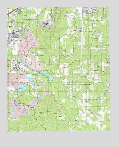
Bryant, AR USGS Topographic Map
Click on map above to begin viewing in our Map Viewer.

This topographic map contains these locations and features:
Feature Name Type Latitude Longitude GNIS ID View Map
Abundant Life Center Assembly of God ChurchChurchN34.6168°W92.4974°65925View Map
African Camp MineMineN34.5495°W92.4927°81726View Map
Alexander CemeteryCemeteryN34.6237°W92.4435°45816View Map
Alexander Hill MineMineN34.5418°W92.4932°81727View Map
Alexander Human Development CenterBuildingN34.6179°W92.4465°65926View Map
Alexander MountainSummitN34.6204°W92.4382°57256View Map
Arkansas Childrens Colony McRae UnitLocaleN34.6162°W92.4482°65928View Map
Ashley ParkParkN34.5931°W92.4932°65929View Map
Ben Ball BridgeBridgeN34.5112°W92.4152°46379View Map
Bertha Extension MineMineN34.5181°W92.4946°81728View Map
Bertha MineMineN34.5165°W92.4840°81729View Map
Bertha Underground MineMineN34.5159°W92.4854°81730View Map
Bethel ChurchChurchN34.5662°W92.4493°46447View Map
Bizzell MineMineN34.5565°W92.4696°81731View Map
Blue BranchStreamN34.5409°W92.4379°76379View Map
Brier Lick BranchStreamN34.5526°W92.4510°46952View Map
BrooksPopulated PlaceN34.5662°W92.4477°57446View Map
Brooks (historical)Populated PlaceN34.5668°W92.4474°65940View Map
Brushy CreekStreamN34.5112°W92.4152°76443View Map
BryantPopulated PlaceN34.5959°W92.4890°57459View Map
Bryant Branch Saline County Public LibraryBuildingN34.5981°W92.4888°65941View Map
Bryant CemeteryCemeteryN34.5865°W92.4932°47101View Map
Bryant Church of ChristChurchN34.6095°W92.4974°65942View Map
Bryant City HallBuildingN34.5929°W92.4918°65943View Map
Bryant Elementary SchoolSchoolN34.6051°W92.4973°65944View Map
Bryant Fire Department Station 1BuildingN34.6205°W92.4926°2116196View Map
Bryant Fire Department Station 2BuildingN34.5927°W92.4909°2116197View Map
Bryant High SchoolSchoolN34.6012°W92.4910°65945View Map
Bryant Junior High School (historical)SchoolN34.6007°W92.4919°65946View Map
Bryant Middle SchoolSchoolN34.6043°W92.4973°2039257View Map
Bryant MineMineN34.5851°W92.4815°81732View Map
Bryant OaksPopulated PlaceN34.6101°W92.4835°65947View Map
Bryant Police DepartmentBuildingN34.5930°W92.4917°2118777View Map
Bryant StadiumParkN34.6015°W92.4971°65948View Map
Butler CemeteryCemeteryN34.5940°W92.4179°65949View Map
Calvary ChurchChurchN34.6170°W92.4046°65951View Map
Canal Number 1 MineMineN34.5562°W92.4863°81733View Map
Canal Number 2 MineMineN34.5584°W92.4843°81734View Map
CareywoodPopulated PlaceN34.6184°W92.4879°65952View Map
Cargill MineMineN34.5254°W92.4679°81735View Map
Cargill MineMineN34.5293°W92.4668°81736View Map
Cargill North Shaft MineMineN34.5279°W92.4649°81737View Map
Cargill South Shaft MineMineN34.5251°W92.4668°81738View Map
Childress MineMineN34.5393°W92.4543°81739View Map
China Grove CemeteriesCemeteryN34.5759°W92.4599°47748View Map
City of AlexanderCivilN34.6182°W92.4513°2403076View Map
City of BryantCivilN34.6144°W92.4903°2403945View Map
City of Shannon HillsCivilN34.6197°W92.4020°2405448View Map
Cleveland MineMineN34.5270°W92.4607°81741View Map
Cleveland MineMineN34.5312°W92.4632°81742View Map
Cleveland-Evans MineMineN34.5356°W92.4618°81740View Map
Cold Spring BranchStreamN34.5706°W92.4815°47905View Map
Covington Number 4 MineMineN34.5587°W92.4515°81743View Map
Covington Number 5 MineMineN34.5559°W92.4524°81744View Map
Davis Main Portal MineMineN34.5409°W92.4979°81745View Map
Dirtdauber (historical)Populated PlaceN34.5495°W92.4885°65960View Map
Dotty LakeLakeN34.5282°W92.4899°74801View Map
Dry CreekStreamN34.5801°W92.3752°45741View Map
East Maud MineMineN34.5248°W92.4893°81746View Map
East Neilson MineMineN34.5265°W92.4793°81747View Map
East Ozark MineMineN34.5326°W92.4582°81748View Map
Ella MineMineN34.5354°W92.4893°81750View Map
Elrod MineMineN34.5818°W92.4807°81751View Map
Emory BranchStreamN34.5256°W92.4268°48894View Map
EvergreenPopulated PlaceN34.6084°W92.4802°65967View Map
Fairview ChurchChurchN34.5098°W92.3871°48972View Map
Fairview School (historical)SchoolN34.5104°W92.3871°65969View Map
First Baptist ChurchChurchN34.5981°W92.4893°65973View Map
First ChurchChurchN34.6212°W92.4010°65974View Map
First Southern Baptist ChurchChurchN34.5893°W92.4921°65982View Map
First United Methodist ChurchChurchN34.5995°W92.4888°65984View Map
Fletcher MineMineN34.5570°W92.4749°81753View Map
Gates MineMineN34.5365°W92.4543°81754View Map
Globe MineMineN34.5176°W92.4824°81756View Map
GoodmanPopulated PlaceN34.5604°W92.4702°57034View Map
Grace Missionary Baptist ChurchChurchN34.6101°W92.4946°65990View Map
Granite Branch MineMineN34.5365°W92.4929°81757View Map
Gray East Pit MineMineN34.5368°W92.4515°81758View Map
Gray West Pit MineMineN34.5381°W92.4560°81759View Map
Guiding Light ChurchChurchN34.6215°W92.3907°65993View Map
Hogue-Fletcher MineMineN34.5720°W92.4821°81760View Map
Hurricane (historical)Populated PlaceN34.5401°W92.4207°65997View Map
Hurricane MineMineN34.5584°W92.4610°81761View Map
Immanuel ChurchChurchN34.6015°W92.4152°65998View Map
Indian Springs Baptist ChurchChurchN34.6209°W92.4893°65999View Map
Indian Springs LakeReservoirN34.6230°W92.4819°74921View Map
Interchange 123CrossingN34.6190°W92.4985°58956View Map
Johnson New Pit MineMineN34.5320°W92.4918°81762View Map
Johnson Old Pit MineMineN34.5348°W92.4915°81763View Map
Julia MineMineN34.5326°W92.4957°81764View Map
King LakeReservoirN34.5851°W92.3885°79345View Map
King Lake DamDamN34.5851°W92.3885°79344View Map
KXIX-FM (Sheridan)TowerN34.5351°W92.4093°85246View Map
Lantz MineMineN34.5520°W92.4996°81765View Map
LignitePopulated PlaceN34.5620°W92.4877°58067View Map
Martin MineMineN34.5918°W92.4788°81768View Map
Mary MineMineN34.5401°W92.4960°81769View Map
McDonald MineMineN34.5373°W92.4535°81770View Map
McPherson CemeteryCemeteryN34.5648°W92.3904°51881View Map
Middle Maud MineMineN34.5273°W92.4938°81771View Map
Midwest MineMineN34.5390°W92.4515°81772View Map
Mine 14MineN34.5462°W92.4677°81773View Map
Moren BranchStreamN34.5018°W92.3985°52182View Map
Mount Olive ChurchChurchN34.5254°W92.4638°52349View Map
Mount Olive School (historical)SchoolN34.5251°W92.4649°66013View Map
Muddy BranchStreamN34.5173°W92.4215°52528View Map
Neilson MineMineN34.5270°W92.4829°81774View Map
Northeast Volunteer Fire Department District 19 Station 1BuildingN34.6120°W92.3924°2116878View Map
Northeast Volunteer Fire Department District 19 Station 2BuildingN34.6008°W92.4178°2116879View Map
Norton MineMineN34.5495°W92.4879°81775View Map
Old Brown Mud Lake DamDamN34.5451°W92.4802°79354View Map
Old Brown Mud LakesReservoirN34.5438°W92.4789°79355View Map
Ozark 24 MineMineN34.5343°W92.4613°81776View Map
Pine HavenPopulated PlaceN34.5648°W92.4896°58375View Map
Plainview ChurchChurchN34.5179°W92.4421°53514View Map
Pleasant Hill Baptist ChurchChurchN34.5295°W92.4079°78045View Map
Quapaw North Pit MineMineN34.5787°W92.4829°81781View Map
Quapaw South Pit MineMineN34.5759°W92.4832°81782View Map
Raintree AcresPopulated PlaceN34.6143°W92.4821°66029View Map
Robert L Davis Elementary SchoolSchoolN34.6059°W92.4968°66032View Map
Rowland MineMineN34.5884°W92.4835°81784View Map
Saline County Regional AirportAirportN34.5877°W92.4828°83637View Map
SardisPopulated PlaceN34.5318°W92.4079°54589View Map
Sardis SchoolSchoolN34.5304°W92.4104°54596View Map
Sardis United Methodist ChurchChurchN34.5326°W92.4132°78298View Map
Sardis Volunteer Fire DepartmentBuildingN34.5296°W92.4081°2117096View Map
Section 10 MineMineN34.5565°W92.4982°81786View Map
Section 14 East Pit MineMineN34.5515°W92.4718°81787View Map
Section 14 West Pit MineMineN34.5529°W92.4807°81788View Map
Section 15 MineMineN34.5429°W92.4949°81789View Map
Section 26 MineMineN34.5209°W92.4815°81792View Map
Shannon HillsPopulated PlaceN34.6201°W92.3954°58601View Map
Shannon Hills City HallBuildingN34.6245°W92.3954°66041View Map
Shannon Hills Police DepartmentBuildingN34.6243°W92.3956°2118783View Map
Shannon Hills Volunteer Fire DepartmentBuildingN34.6250°W92.3911°2117115View Map
Stringtown MineMineN34.5440°W92.4918°81801View Map
Styres LakeReservoirN34.6151°W92.3802°79339View Map
Styres Lake DamDamN34.6151°W92.3802°79338View Map
Surge PondReservoirN34.5784°W92.4763°79347View Map
Surge Pond DamDamN34.5768°W92.4768°79346View Map
Surge Pond DamDamN34.5801°W92.4752°79348View Map
Thomas McRae Tuberculosis HomeHospitalN34.6168°W92.4474°55529View Map
Town of BauxiteCivilN34.5605°W92.4988°2405215View Map
Townsend MineMineN34.5584°W92.4724°81803View Map
Township of BryantCivilN34.5971°W92.4871°66941View Map
Township of HurricaneCivilN34.5137°W92.3880°69042View Map
Township of OtterCivilN34.5923°W92.3964°69048View Map
Twin OaksPopulated PlaceN34.6123°W92.4918°66054View Map
Ulmer MineMineN34.5556°W92.4632°81804View Map
Vimy RidgePopulated PlaceN34.6012°W92.4135°78660View Map
Vimy Ridge ChurchChurchN34.6012°W92.4132°66057View Map
Vimy Ridge ChurchChurchN34.6151°W92.4168°66058View Map
West Elrod MineMineN34.5820°W92.4849°81805View Map
West Maud Extension MineMineN34.5215°W92.4927°81806View Map
West Maud MineMineN34.5240°W92.4960°81807View Map
West Ozark MineMineN34.5329°W92.4649°81808View Map
Wilbur Mills ParkParkN34.6073°W92.4835°66063View Map
Woodland HillsPopulated PlaceN34.6084°W92.4515°66067View Map
Woodland Hills Volunteer Fire Department Station 1BuildingN34.6102°W92.4466°2117331View Map
Woodland Hills Volunteer Fire Department Station 2BuildingN34.6107°W92.4714°2117332View Map

Note: Coordinates in the location and feature list above are referenced to NAD83 datum.


Copyright (C) 2008-2024 Ryan Niemi / Sunset Dynamics ... All Rights Reserved