TopoQuest Logo
Do you find TopoQuest useful?
Help keep TopoQuest running and adding new maps/features by donating!
Bitcoin:  19c7KJd3qBynnjoSw5npx9KScwjBe4ifkT
Litecoin:  LXs6TkuXGGXo1vDsWCkWVdjQX94eUKd6ui
Home View Maps Find Maps Find Places Resources & Links


Brushy Creek, Texas Topographic Map

USGS Map Title: Brushy Creek, TX
USGS Map MRC: 31093F7
DRG (GeoTIFF) Download: o31093f7.tif


Neighboring USGS Topographic Map Quads:


  Huxley, TX  
31093G8
 

  Union Springs, LA  
31093G7
 

  Converse, LA  
31093G6
 

  Patroon North, TX  
31093F8
 

  Brushy Creek, TX  
31093F7
 

  Zwolle, LA  
31093F6
 

  Patroon South, TX  
31093E8
 

  East Hamilton, TX  
31093E7
 

  Beech Bayou, LA  
31093E6


Map MRC Location:

N32°
W94°
N32°
W93°
H8 H7 H6 H5 H4 H3 H2 H1
G8 G7 G6 G5 G4 G3 G2 G1
F8 F7 F6 F5 F4 F3 F2 F1
E8 E7 E6 E5 E4 E3 E2 E1
D8 D7 D6 D5 D4 D3 D2 D1
C8 C7 C6 C5 C4 C3 C2 C1
B8 B7 B6 B5 B4 B3 B2 B1
A8 A7 A6 A5 A4 A3 A2 A1
N31°
W94°
N31°
W93°

Brushy Creek, TX USGS 1:24K Topographic Map Preview:
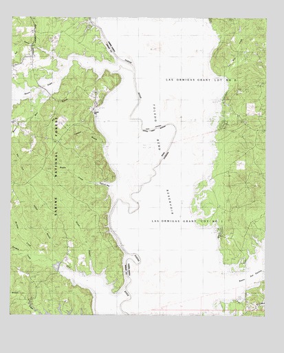
Brushy Creek, TX USGS Topographic Map
Click on map above to begin viewing in our Map Viewer.

This topographic map contains these locations and features:
Feature Name Type Latitude Longitude GNIS ID View Map
Bayou BlueStreamN31.7163°W93.8632°1381365View Map
Big BranchStreamN31.6838°W93.8069°1381420View Map
Bowen BranchStreamN31.6324°W93.8160°1381494View Map
Brown School (historical)SchoolN31.7024°W93.7516°546084View Map
Browns BendBendN31.6941°W93.8019°1381524View Map
Brushy CreekStreamN31.6718°W93.8244°1381534View Map
Buzzard Bend (historical)BendN31.6696°W93.8135°547157View Map
Charley Buck SloughGutN31.6438°W93.8127°547209View Map
Clemens BranchStreamN31.6771°W93.8157°1381664View Map
EbarbLocaleN31.6313°W93.7538°548253View Map
Ebarb High SchoolSchoolN31.6304°W93.7512°2462780View Map
Haley Ferry (historical)CrossingN31.7296°W93.8149°546121View Map
Half BranchStreamN31.7324°W93.8477°1381961View Map
Horseshoe SloughGutN31.6824°W93.8163°1382035View Map
Jones Old RiverLakeN31.6693°W93.8221°547529View Map
Kilgore SloughGutN31.7438°W93.8224°547545View Map
McGrue CreekStreamN31.6466°W93.8499°1383134View Map
North Sabine Fire Protection District Hotwell StationBuildingN31.6566°W93.7648°2673105View Map
Parish Governing Authority District 7CivilN31.7446°W93.7527°1930203View Map
Pleasant Hill ChurchChurchN31.7063°W93.8396°1382533View Map
Prairie SloughGutN31.6468°W93.8074°547870View Map
Ragtown Recreation SiteLocaleN31.6816°W93.8330°1384847View Map
Round LakeLakeN31.7418°W93.7960°547916View Map
Round Lake Swamp (historical)SwampN31.7160°W93.7788°546167View Map
Saline Lake (historical)LakeN31.7488°W93.7969°546177View Map
San Patricio LakeLakeN31.6410°W93.8060°547951View Map
Sanders CreekStreamN31.6466°W93.8499°1382701View Map
Silvie Bend (historical)BendN31.6491°W93.8121°547996View Map
Snyders Boat RampLocaleN31.6971°W93.8296°1384846View Map
Soto Saline SloughGutN31.7482°W93.8110°548010View Map
Sulphur Springs SloughGutN31.7107°W93.7932°548052View Map
Ten Acre CreekStreamN31.7266°W93.7710°548072View Map
Tiger Lake SloughGutN31.6899°W93.8207°1382865View Map
West Hamilton ChurchChurchN31.6510°W93.8477°1382936View Map
Yellow BranchStreamN31.6463°W93.8502°1383002View Map

Note: Coordinates in the location and feature list above are referenced to NAD83 datum.


Copyright (C) 2008-2024 Ryan Niemi / Sunset Dynamics ... All Rights Reserved