TopoQuest Logo
Do you find TopoQuest useful?
Help keep TopoQuest running and adding new maps/features by donating!
Bitcoin:  19c7KJd3qBynnjoSw5npx9KScwjBe4ifkT
Litecoin:  LXs6TkuXGGXo1vDsWCkWVdjQX94eUKd6ui
Home View Maps Find Maps Find Places Resources & Links


Brownfield, Illinois Topographic Map

USGS Map Title: Brownfield, IL
USGS Map MRC: 37088C5
DRG (GeoTIFF) Download: o37088c5.tif


Neighboring USGS Topographic Map Quads:


  Glendale, IL  
37088D6
 

  Waltersburg, IL  
37088D5
 

  Shetlerville, IL  
37088D4
 

  Reevesville, IL  
37088C6
 

  Brownfield, IL  
37088C5
 

  Golconda, IL  
37088C4
 

  Metropolis, IL  
37088B6
 

  Paducah NE, IL  
37088B5
 

  Smithland, KY  
37088B4


Map MRC Location:

N38°
W89°
N38°
W88°
H8 H7 H6 H5 H4 H3 H2 H1
G8 G7 G6 G5 G4 G3 G2 G1
F8 F7 F6 F5 F4 F3 F2 F1
E8 E7 E6 E5 E4 E3 E2 E1
D8 D7 D6 D5 D4 D3 D2 D1
C8 C7 C6 C5 C4 C3 C2 C1
B8 B7 B6 B5 B4 B3 B2 B1
A8 A7 A6 A5 A4 A3 A2 A1
N37°
W89°
N37°
W88°

Brownfield, IL USGS 1:24K Topographic Map Preview:
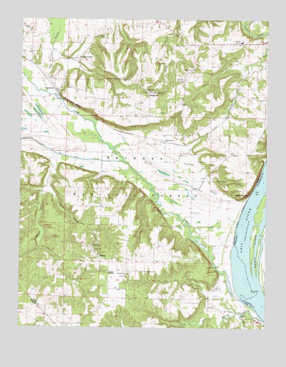
Brownfield, IL USGS Topographic Map
Click on map above to begin viewing in our Map Viewer.

This topographic map contains these locations and features:
Feature Name Type Latitude Longitude GNIS ID View Map
Antioch CemeteryCemeteryN37.2839°W88.5884°1820630View Map
Antioch ChurchChurchN37.2831°W88.5878°424573View Map
Baker CemeteryCemeteryN37.3370°W88.5545°424589View Map
Barren CreekStreamN37.2534°W88.5009°424598View Map
Bay CreekStreamN37.2614°W88.5120°424607View Map
Bethany CemeteryCemeteryN37.3450°W88.5562°1820634View Map
Bethany ChurchChurchN37.3451°W88.5564°424634View Map
Bradford CemeteryCemeteryN37.2967°W88.5384°424666View Map
BrownfieldPopulated PlaceN37.3456°W88.6070°424678View Map
Brownfield BluffCliffN37.3406°W88.5984°424679View Map
Brownfield Post OfficePost OfficeN37.3459°W88.6070°1820636View Map
Caney CreekStreamN37.2542°W88.5120°424710View Map
Cave CreekStreamN37.2562°W88.5142°424723View Map
Cave Spring School (historical)SchoolN37.2581°W88.5303°1725756View Map
Cement HollowValleyN37.3561°W88.5141°424732View Map
Compton CemeteryCemeteryN37.3500°W88.5428°424769View Map
Cooney CreekStreamN37.2517°W88.5223°424773View Map
Cromeenes HollowValleyN37.3056°W88.6101°424797View Map
Deputy HillSummitN37.3514°W88.5787°423613View Map
Deputy Lookout TowerTowerN37.3506°W88.5750°424830View Map
Fields CemeteryCemeteryN37.3681°W88.5859°424889View Map
Flat Lick BranchStreamN37.3456°W88.6128°424891View Map
Foote CemeteryCemeteryN37.3437°W88.5048°424898View Map
Foreman CemeteryCemeteryN37.3198°W88.5450°424899View Map
Golconda Number 1 Election PrecinctCivilN37.3586°W88.5635°1928504View Map
Gregory CemeteryCemeteryN37.3548°W88.5389°424950View Map
Hemphill CemeteryCemeteryN37.3164°W88.5381°424974View Map
Hodge CemeteryCemeteryN37.3464°W88.5620°424995View Map
HodgevillePopulated PlaceN37.3456°W88.5603°424996View Map
Hodgeville School (historical)SchoolN37.3489°W88.5650°1725770View Map
HombergPopulated PlaceN37.3253°W88.5520°425007View Map
Independence CemeteryCemeteryN37.2731°W88.5609°1820650View Map
Independence ChurchChurchN37.2728°W88.5609°425028View Map
Independence SchoolSchoolN37.2714°W88.5698°425029View Map
Lackey BridgeBridgeN37.2748°W88.5250°425087View Map
Lewis CornerPopulated PlaceN37.2726°W88.5795°425102View Map
Normal School (historical)SchoolN37.3023°W88.5842°1725780View Map
Old BrownfieldPopulated PlaceN37.3589°W88.5964°425270View Map
Pope County High SchoolSchoolN37.3662°W88.5134°1820663View Map
Prospect CemeteryCemeteryN37.3453°W88.5609°425354View Map
Robnett CreekStreamN37.3206°W88.6075°425394View Map
Roper CemeteryCemeteryN37.3175°W88.5311°425413View Map
Ropers LandingLocaleN37.3039°W88.5089°425414View Map
RosebudPopulated PlaceN37.2784°W88.5839°425420View Map
Shedville CemeteryCemeteryN37.3712°W88.6203°425474View Map
Sisters IslandsIslandN37.2828°W88.5059°503580View Map
Stony Point School (historical)SchoolN37.3698°W88.5453°1725791View Map
TansillPopulated PlaceN37.3062°W88.5378°425549View Map
Williams CemeteryCemeteryN37.3098°W88.5253°425640View Map

Note: Coordinates in the location and feature list above are referenced to NAD83 datum.


Copyright (C) 2008-2024 Ryan Niemi / Sunset Dynamics ... All Rights Reserved