TopoQuest Logo
Do you find TopoQuest useful?
Help keep TopoQuest running and adding new maps/features by donating!
Bitcoin:  19c7KJd3qBynnjoSw5npx9KScwjBe4ifkT
Litecoin:  LXs6TkuXGGXo1vDsWCkWVdjQX94eUKd6ui
Home View Maps Find Maps Find Places Resources & Links


Bristol Springs, New York Topographic Map

USGS Map Title: Bristol Springs, NY
USGS Map MRC: 42077F4
DRG (GeoTIFF) Download: o42077f4.tif


Neighboring USGS Topographic Map Quads:


  Honeoye, NY  
42077G5
 

  Bristol Center, NY  
42077G4
 

  Canandaigua Lake, NY  
42077G3
 

  Springwater, NY  
42077F5
 

  Bristol Springs, NY  
42077F4
 

  Middlesex, NY  
42077F3
 

  Wayland, NY  
42077E5
 

  Naples, NY  
42077E4
 

  Prattsburg, NY  
42077E3


Map MRC Location:

N43°
W78°
N43°
W77°
H8 H7 H6 H5 H4 H3 H2 H1
G8 G7 G6 G5 G4 G3 G2 G1
F8 F7 F6 F5 F4 F3 F2 F1
E8 E7 E6 E5 E4 E3 E2 E1
D8 D7 D6 D5 D4 D3 D2 D1
C8 C7 C6 C5 C4 C3 C2 C1
B8 B7 B6 B5 B4 B3 B2 B1
A8 A7 A6 A5 A4 A3 A2 A1
N42°
W78°
N42°
W77°

Bristol Springs, NY USGS 1:24K Topographic Map Preview:
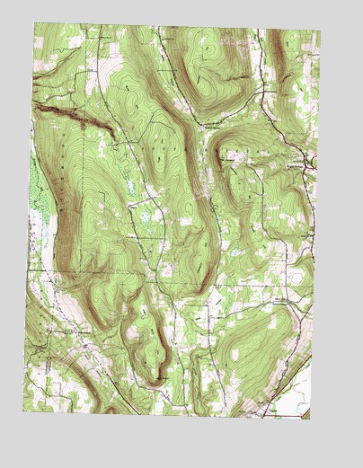
Bristol Springs, NY USGS Topographic Map
Click on map above to begin viewing in our Map Viewer.

This topographic map contains these locations and features:
Feature Name Type Latitude Longitude GNIS ID View Map
Boswell CornersPopulated PlaceN42.7187°W77.4244°944476View Map
Bristol SpringsPopulated PlaceN42.7062°W77.3800°944772View Map
Bristol Springs Free ChurchChurchN42.7059°W77.3797°2615634View Map
Calvary Chapel of Bristol HillsChurchN42.6428°W77.4676°2615665View Map
Cleveland HillSummitN42.6767°W77.4247°946853View Map
Fairview CemeteryCemeteryN42.6261°W77.3966°2542306View Map
Frost HillSummitN42.7112°W77.4430°950764View Map
Gannett HillSummitN42.7001°W77.4086°950870View Map
GulickPopulated PlaceN42.6917°W77.4561°972579View Map
High PointCliffN42.6373°W77.4405°952751View Map
High Point HillSummitN42.6459°W77.4447°952755View Map
Hunt HollowPopulated PlaceN42.6512°W77.4769°972639View Map
Hunt HollowValleyN42.6667°W77.4945°953463View Map
Hunt's Hollow CemeteryCemeteryN42.6638°W77.4871°953464View Map
Maxfield Hose Company Station 2BuildingN42.7112°W77.3815°2735515View Map
Mountain Creek Herb FarmLocaleN42.6506°W77.4208°2559140View Map
Pamely CemeteryCemeteryN42.7459°W77.4436°959805View Map
Powell HillSummitN42.6892°W77.4019°961078View Map
Quail HillSummitN42.7234°W77.4572°962028View Map
School Number 11 (historical)SchoolN42.7451°W77.4711°974985View Map
School Number 2 (historical)SchoolN42.6634°W77.3864°975180View Map
School Number 3 (historical)SchoolN42.7076°W77.3789°975260View Map
School Number 4 (historical)SchoolN42.6840°W77.3761°975341View Map
School Number 7 (historical)SchoolN42.6506°W77.4778°975532View Map
Semans CornerPopulated PlaceN42.6628°W77.3858°973050View Map
South BristolPopulated PlaceN42.7298°W77.3992°973089View Map
Stid HillSummitN42.7467°W77.3872°966418View Map
The JumpoffCliffN42.7081°W77.4178°967271View Map
Town of South BristolCivilN42.7157°W77.4091°979506View Map
Worden HillSummitN42.7312°W77.4261°971742View Map
WZSH-FM (Town of South Bristol)TowerN42.7465°W77.4261°978605View Map

Note: Coordinates in the location and feature list above are referenced to NAD83 datum.


Copyright (C) 2008-2024 Ryan Niemi / Sunset Dynamics ... All Rights Reserved