TopoQuest Logo
Do you find TopoQuest useful?
Help keep TopoQuest running and adding new maps/features by donating!
Bitcoin:  19c7KJd3qBynnjoSw5npx9KScwjBe4ifkT
Litecoin:  LXs6TkuXGGXo1vDsWCkWVdjQX94eUKd6ui
Home View Maps Find Maps Find Places Resources & Links


Brazoria, Texas Topographic Map

USGS Map Title: Brazoria, TX
USGS Map MRC: 29095A5
DRG (GeoTIFF) Download: o29095a5.tif


Neighboring USGS Topographic Map Quads:


  West Columbia, TX  
29095B6
 

  East Columbia, TX  
29095B5
 

  Angleton, TX  
29095B4
 

  Sweeny, TX  
29095A6
 

  Brazoria, TX  
29095A5
 

  Lake Jackson, TX  
29095A4
 

  Cedar Lane, TX  
28095H6
 

  Cedar Lane NE, TX  
28095H5
 

  Jones Creek, TX  
28095H4


Map MRC Location:

N30°
W96°
N30°
W95°
H8 H7 H6 H5 H4 H3 H2 H1
G8 G7 G6 G5 G4 G3 G2 G1
F8 F7 F6 F5 F4 F3 F2 F1
E8 E7 E6 E5 E4 E3 E2 E1
D8 D7 D6 D5 D4 D3 D2 D1
C8 C7 C6 C5 C4 C3 C2 C1
B8 B7 B6 B5 B4 B3 B2 B1
A8 A7 A6 A5 A4 A3 A2 A1
N29°
W96°
N29°
W95°

Brazoria, TX USGS 1:24K Topographic Map Preview:
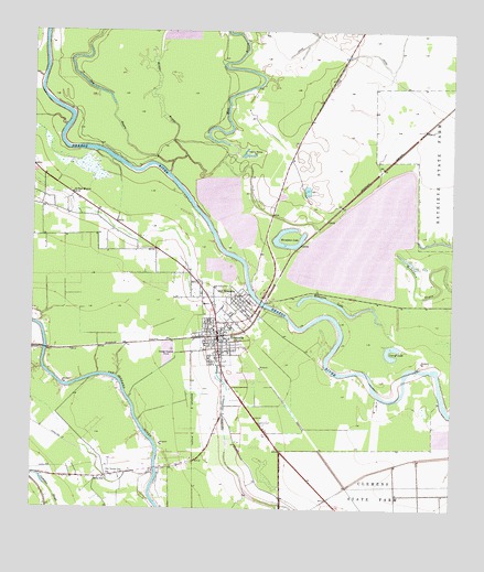
Brazoria, TX USGS Topographic Map
Click on map above to begin viewing in our Map Viewer.

This topographic map contains these locations and features:
Feature Name Type Latitude Longitude GNIS ID View Map
Barrow Elementary SchoolSchoolN29.0508°W95.5689°2003544View Map
BrazoriaPopulated PlaceN29.0444°W95.5691°1352845View Map
Brazoria BridgeBridgeN29.0544°W95.5572°2030655View Map
Brazoria City HallBuildingN29.0443°W95.5688°2753368View Map
Brazoria City ParkParkN29.0447°W95.5616°2028716View Map
Brazoria City ReservoirReservoirN29.0402°W95.5852°1857688View Map
Brazoria City Reservoir LeveeDamN29.0402°W95.5852°1857687View Map
Brazoria Fire DepartmentBuildingN29.0447°W95.5697°2334497View Map
Brazoria Fire Department Station 2BuildingN29.0355°W95.5675°2334368View Map
Brazoria Intermediate SchoolSchoolN29.0489°W95.5630°2003480View Map
Brazoria Police DepartmentBuildingN29.0443°W95.5693°2375947View Map
Brazoria Post OfficePost OfficeN29.0524°W95.5700°2731771View Map
Brazoria ReservoirReservoirN29.0699°W95.5273°1857686View Map
Brazoria ReservoirLakeN29.0538°W95.5347°1352846View Map
Brazoria Reservoir DamDamN29.0686°W95.5286°1857685View Map
Brazoria Volunteer Fire DepartmentBuildingN29.0461°W95.5704°2334476View Map
City of BrazoriaCivilN29.0455°W95.5668°2409894View Map
Clemens Reservoir Number 2ReservoirN29.0194°W95.5023°1857644View Map
Clemens Reservoir Number 2 LeveeDamN29.0219°W95.5002°1857643View Map
Cut-Off LakeLakeN29.0401°W95.5177°1355499View Map
Dacus LakeReservoirN29.0602°W95.5636°1857640View Map
Dacus Lake DamDamN29.0602°W95.5636°1857639View Map
Dry BayouStreamN29.0914°W95.5824°1356272View Map
Fontaine LeveeDamN29.0752°W95.5719°1857683View Map
Horseshoe LakeLakeN29.0691°W95.5487°1359644View Map
Middle BayouStreamN29.0880°W95.5841°1362695View Map
Mill BayouStreamN29.0733°W95.5391°1362844View Map
Mims SchoolSchoolN29.0086°W95.6030°1362937View Map
Old BrazoriaPopulated PlaceN29.0555°W95.5652°1364399View Map
Saint Paul MissionChurchN29.0825°W95.6133°1367300View Map
West Brazos Junior High SchoolSchoolN29.0725°W95.5899°2434411View Map
Wild PeachPopulated PlaceN29.0683°W95.6216°2035009View Map
Wild Peach Elementary SchoolSchoolN29.0760°W95.6169°2434427View Map
York ReservoirReservoirN29.0798°W95.5732°1857684View Map
Zion Temple CemeteryCemeteryN29.0100°W95.5974°1372104View Map

Note: Coordinates in the location and feature list above are referenced to NAD83 datum.


Copyright (C) 2008-2024 Ryan Niemi / Sunset Dynamics ... All Rights Reserved