TopoQuest Logo
Do you find TopoQuest useful?
Help keep TopoQuest running and adding new maps/features by donating!
Bitcoin:  19c7KJd3qBynnjoSw5npx9KScwjBe4ifkT
Litecoin:  LXs6TkuXGGXo1vDsWCkWVdjQX94eUKd6ui
Home View Maps Find Maps Find Places Resources & Links


Bradley, Alabama Topographic Map

USGS Map Title: Bradley, AL
USGS Map MRC: 31086A6
DRG (GeoTIFF) Download: o31086a6.tif


Neighboring USGS Topographic Map Quads:


  Damascus, AL  
31086B7
 

  Dixie, AL  
31086B6
 

  Carolina, AL  
31086B5
 

  Parker Springs, AL  
31086A7
 

  Bradley, AL  
31086A6
 

  Wing, AL  
31086A5
 

  Hurricane Lake, FL  
30086H7
 

  Blackman, FL  
30086H6
 

  Oak Grove, FL  
30086H5


Map MRC Location:

N32°
W87°
N32°
W86°
H8 H7 H6 H5 H4 H3 H2 H1
G8 G7 G6 G5 G4 G3 G2 G1
F8 F7 F6 F5 F4 F3 F2 F1
E8 E7 E6 E5 E4 E3 E2 E1
D8 D7 D6 D5 D4 D3 D2 D1
C8 C7 C6 C5 C4 C3 C2 C1
B8 B7 B6 B5 B4 B3 B2 B1
A8 A7 A6 A5 A4 A3 A2 A1
N31°
W87°
N31°
W86°

Bradley, AL USGS 1:24K Topographic Map Preview:
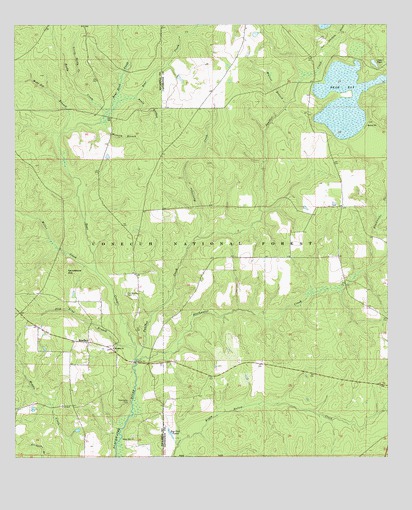
Bradley, AL USGS Topographic Map
Click on map above to begin viewing in our Map Viewer.

This topographic map contains these locations and features:
Feature Name Type Latitude Longitude GNIS ID View Map
Bear BayLakeN31.1033°W86.6395°159126View Map
Bear CreekStreamN31.0288°W86.7097°159129View Map
Bear Head CreekStreamN31.0968°W86.7219°159131View Map
Blackwater CemeteryCemeteryN31.0157°W86.7125°159195View Map
Blackwater CreekStreamN31.0288°W86.7097°159196View Map
BradleyPopulated PlaceN31.0335°W86.7255°159243View Map
Bradley Assembly of God ChurchChurchN31.0316°W86.7175°159244View Map
Bradley Church CemeteryCemeteryN31.0313°W86.7175°161651View Map
Bradley Volunteer Fire DepartmentBuildingN31.0333°W86.7267°2331083View Map
Conecuh National ForestForestN31.0943°W86.6342°164524View Map
Fish Trap BranchStreamN31.0321°W86.7094°159599View Map
Geneva County Grammar SchoolSchoolN31.0985°W86.6997°137043View Map
Hickory BranchStreamN31.0968°W86.7219°159761View Map
Hurricane CreekStreamN31.0638°W86.6900°159831View Map
Little Reedy CreekStreamN31.1093°W86.7311°159980View Map
Miller CreekStreamN31.0538°W86.7230°160109View Map
Old Bradley CemeteryCemeteryN31.0471°W86.7130°160298View Map
Otter PondReservoirN31.1138°W86.6291°160325View Map
Panther CreekStreamN31.0291°W86.7094°160336View Map
Pauls BranchStreamN31.1038°W86.7108°160349View Map
Reedy CreekStreamN31.0999°W86.7200°160481View Map
Roy Cook PondsReservoirN31.0062°W86.6973°160542View Map
Salem Church (historical)ChurchN31.0452°W86.6925°161642View Map
Sand PointCapeN31.0952°W86.6327°160560View Map
Sandstone HillSummitN31.0560°W86.7316°160562View Map
Union Hill ChurchChurchN31.0057°W86.7102°160779View Map
Union Hill Church CemeteryCemeteryN31.0063°W86.7108°161697View Map
Walnut BranchStreamN31.1013°W86.6597°160797View Map
Wolf Pit BranchStreamN31.0941°W86.7338°160864View Map

Note: Coordinates in the location and feature list above are referenced to NAD83 datum.


Copyright (C) 2008-2024 Ryan Niemi / Sunset Dynamics ... All Rights Reserved