TopoQuest Logo
Do you find TopoQuest useful?
Help keep TopoQuest running and adding new maps/features by donating!
Bitcoin:  19c7KJd3qBynnjoSw5npx9KScwjBe4ifkT
Litecoin:  LXs6TkuXGGXo1vDsWCkWVdjQX94eUKd6ui
Home View Maps Find Maps Find Places Resources & Links


Wolfeboro, New Hampshire Topographic Map

USGS Map Title: Wolfeboro, NH
USGS Map MRC: 43071E2
DRG (GeoTIFF) Download: o43071e2.tif


Neighboring USGS Topographic Map Quads:


  Melvin Village, NH  
43071F3
 

  Tuftonboro, NH  
43071F2
 

  Ossipee, NH  
43071F1
 

  West Alton, NH  
43071E3
 

  Wolfeboro, NH  
43071E2
 

  Sanbornville, NH  
43071E1
 

  Gilmanton Ironworks, NH  
43071D3
 

  Alton, NH  
43071D2
 

  Farmington, NH  
43071D1


Map MRC Location:

N44°
W72°
N44°
W71°
H8 H7 H6 H5 H4 H3 H2 H1
G8 G7 G6 G5 G4 G3 G2 G1
F8 F7 F6 F5 F4 F3 F2 F1
E8 E7 E6 E5 E4 E3 E2 E1
D8 D7 D6 D5 D4 D3 D2 D1
C8 C7 C6 C5 C4 C3 C2 C1
B8 B7 B6 B5 B4 B3 B2 B1
A8 A7 A6 A5 A4 A3 A2 A1
N43°
W72°
N43°
W71°

Wolfeboro, NH USGS 1:24K Topographic Map Preview:
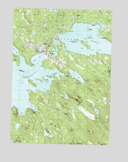
Wolfeboro, NH USGS Topographic Map
Click on map above to begin viewing in our Map Viewer.

This topographic map contains these locations and features:
Feature Name Type Latitude Longitude GNIS ID View Map
Abenaki Ski AreaLocaleN43.6115°W71.2278°1915866View Map
Allen Albee BeachBeachN43.6034°W71.1837°1915869View Map
Baker BrookStreamN43.5623°W71.1623°1915874View Map
Barndoor IslandIslandN43.5548°W71.2237°865382View Map
Bass IslandIslandN43.5895°W71.1620°865410View Map
Bay Street Discount Shopping CenterLocaleN43.5873°W71.2173°1915879View Map
Beaver BrookStreamN43.5473°W71.2090°865475View Map
Bennett HillSummitN43.6190°W71.2201°865545View Map
Black PointCapeN43.5334°W71.2481°865631View Map
Blueberry IslandIslandN43.5551°W71.2115°1915885View Map
Breeze PointCapeN43.5854°W71.1417°865775View Map
Brewster AcademySchoolN43.5824°W71.2075°865782View Map
Brewster BeachBeachN43.5777°W71.2092°1915886View Map
Brummet IslandIslandN43.5884°W71.1420°865833View Map
Carpenter Elementary SchoolSchoolN43.5849°W71.2097°1915900View Map
Cate IslandIslandN43.5879°W71.1509°866046View Map
Cate ParkParkN43.5834°W71.2101°1915902View Map
Cates HillSummitN43.5159°W71.1906°866047View Map
Caverly MountainSummitN43.5137°W71.1512°866056View Map
Center Square HillSummitN43.6201°W71.1878°866087View Map
Chestnut CoveBayN43.5284°W71.2370°866144View Map
Chip IslandIslandN43.5537°W71.2062°1915913View Map
Church IslandIslandN43.5545°W71.2070°1915917View Map
Clark House MuseumBuildingN43.5826°W71.2059°1915919View Map
Clark PointCapeN43.5723°W71.2120°866183View Map
Clay Pit BrookStreamN43.6117°W71.1431°866202View Map
Clay PointCapeN43.5492°W71.2290°866203View Map
Clows BeachBeachN43.6117°W71.1467°1915920View Map
Crescent LakeLakeN43.5875°W71.1948°866397View Map
Crescent Lake DamDamN43.5901°W71.2012°1775309View Map
Crescent Lake SchoolSchoolN43.5786°W71.1831°2500277View Map
Delings CoveBayN43.5609°W71.1901°1915934View Map
Depot SquareBuildingN43.5845°W71.2117°1915935View Map
Derby MountainSummitN43.5267°W71.2428°866552View Map
Devils Den MountainSummitN43.5129°W71.1748°866564View Map
East AltonPopulated PlaceN43.5181°W71.1998°866684View Map
East Alton Fire and Rescue DepartmentBuildingN43.5215°W71.2069°2605241View Map
Evangelical Bible ChurchChurchN43.5859°W71.2109°1915954View Map
Evans HillSummitN43.5131°W71.2251°866818View Map
FernaldPopulated PlaceN43.6134°W71.1692°866859View Map
Fernald BrookStreamN43.6134°W71.1709°866860View Map
Fernalds BasinBayN43.6012°W71.1923°1915957View Map
First Christian ChurchChurchN43.5854°W71.2162°1915959View Map
First Congregational ChurchChurchN43.5804°W71.2003°1915962View Map
First Freewill Baptist ChurchChurchN43.5190°W71.2001°1915035View Map
Fishermans CoveBayN43.5654°W71.1973°1915963View Map
Flo IslandIslandN43.5951°W71.1684°1915964View Map
Foss FieldParkN43.5873°W71.2095°1915965View Map
Front BayLakeN43.5888°W71.2107°866993View Map
Frost BrookStreamN43.6095°W71.1309°866995View Map
Frost CornerLocaleN43.6162°W71.1281°1916184View Map
Furber HillSummitN43.6159°W71.2015°867005View Map
Furber PointCapeN43.5640°W71.1892°1915970View Map
Gate IslandIslandN43.5584°W71.2070°1915972View Map
Gilman PondLakeN43.5091°W71.2025°867071View Map
Goodwins BasinBayN43.5967°W71.1992°1915974View Map
Goose CornerPopulated PlaceN43.6006°W71.2440°1915975View Map
Goose RockBarN43.6059°W71.1745°867127View Map
Gull RockPillarN43.5912°W71.1820°867283View Map
Harbor IslandIslandN43.5620°W71.2109°1915982View Map
Hardhead HillSummitN43.5287°W71.2240°867369View Map
Harmony IslandIslandN43.5567°W71.2065°1915983View Map
Harvey BrookStreamN43.6017°W71.1881°867397View Map
Hayes HillSummitN43.5265°W71.1762°867421View Map
Heath BrookStreamN43.5865°W71.1776°867435View Map
Hersey BrookStreamN43.6040°W71.1834°867466View Map
Hersey CemeteryCemeteryN43.6206°W71.2374°867467View Map
Hersey PointCapeN43.6048°W71.1776°867469View Map
Huggins HospitalHospitalN43.5819°W71.2008°867670View Map
Huggins Hospital LibraryBuildingN43.5815°W71.2003°1915987View Map
Hurd BrookStreamN43.5265°W71.2323°867691View Map
Jennes LandingLocaleN43.6126°W71.1712°1915997View Map
JIB IslandIslandN43.5870°W71.2070°1915992View Map
Jockey Cap IslandIslandN43.6006°W71.1540°867788View Map
Jockey CoveBayN43.5759°W71.2373°1915999View Map
Joe IslandIslandN43.5956°W71.1692°1916000View Map
Keel IslandIslandN43.5523°W71.2073°1916007View Map
Keniston IslandIslandN43.5581°W71.2140°867840View Map
Kingswood Golf CourseLocaleN43.5765°W71.1967°1916009View Map
Kingswood Regional High SchoolSchoolN43.5756°W71.1895°1916010View Map
Kingswood Regional Middle SchoolSchoolN43.5759°W71.1882°1916011View Map
Knights PondLakeN43.5441°W71.1802°867903View Map
Lake WentworthLakeN43.5967°W71.1566°870737View Map
Lakeview CemeteryCemeteryN43.5926°W71.2286°867930View Map
Ledge IslandIslandN43.5551°W71.2081°1916016View Map
Little Barndoor IslandIslandN43.5612°W71.2303°868036View Map
Little Kenniston IslandIslandN43.5559°W71.2117°1916020View Map
Long Pine IslandIslandN43.5545°W71.2098°1916023View Map
Loon IslandIslandN43.5965°W71.1662°1916024View Map
Lord Ambulance Service / Lakeside Ambulance ServiceBuildingN43.5872°W71.2074°2658895View Map
McKinney ParkParkN43.5717°W71.2120°1916038View Map
Melody IslandIslandN43.5601°W71.2098°1916039View Map
Min IslandIslandN43.5951°W71.1681°1916042View Map
Mink IslandIslandN43.5987°W71.1548°868487View Map
Moose PointCapeN43.6017°W71.1856°1916045View Map
Morrill BrookStreamN43.6076°W71.1398°1916046View Map
Mount Long StackSummitN43.5423°W71.1662°868597View Map
Mount MollySummitN43.5004°W71.1720°868515View Map
Mud IslandIslandN43.5540°W71.2053°1916059View Map
Outlook HillSummitN43.5576°W71.1673°868953View Map
Overnight IslandIslandN43.5542°W71.2087°1916080View Map
Perry BrookStreamN43.5581°W71.1578°869091View Map
Perry Hollow Golf and Country ClubLocaleN43.5784°W71.1876°1916084View Map
Pine HillSummitN43.6059°W71.2081°869182View Map
Pine Hill CemeteryCemeteryN43.6081°W71.2132°869190View Map
Pipers PointCapeN43.5504°W71.2184°1915139View Map
Point of PinesCapeN43.5852°W71.1405°1916089View Map
Poor Farm HillSummitN43.6045°W71.2303°869303View Map
Poplar IslandIslandN43.5967°W71.1695°1916090View Map
Puffs CoveBayN43.5640°W71.1948°1916093View Map
Rines HillSummitN43.5359°W71.1828°869501View Map
Roberts CoveBayN43.5345°W71.2240°869542View Map
Rust PondReservoirN43.5635°W71.1681°869653View Map
Rust Pond DamDamN43.5634°W71.1745°1774960View Map
Ryefield BrookStreamN43.6101°W71.1403°869665View Map
Ryefield MarshSwampN43.6108°W71.1339°1916098View Map
Sargents PondLakeN43.6240°W71.1999°869794View Map
Scavenger IslandIslandN43.5537°W71.2070°1916110View Map
Seven Sisters IslandsIslandN43.5962°W71.1695°869850View Map
Sewalls PointCapeN43.5717°W71.2245°869854View Map
Shaws PondLakeN43.5332°W71.1426°869888View Map
Shelter IslandIslandN43.5595°W71.2076°1916111View Map
South WolfeboroPopulated PlaceN43.5615°W71.1773°870065View Map
South Wolfeboro BayBayN43.5648°W71.1853°1916121View Map
South Wolfeboro PlaygroundParkN43.5640°W71.1751°1916122View Map
Spider IslandIslandN43.5529°W71.2090°1916123View Map
Spray Irrigation Storage Reservoir DamDamN43.6034°W71.2245°1775729View Map
Springfield PointCapeN43.5651°W71.1970°870108View Map
Springfield Point HeliportAirportN43.5579°W71.1912°873455View Map
Stamp Act IslandIslandN43.5934°W71.1601°870134View Map
Sunset PointCapeN43.5840°W71.1506°1916126View Map
Tips CoveBayN43.5742°W71.2459°1916133View Map
Town of WolfeboroCivilN43.6117°W71.1706°873760View Map
Townsend BrookStreamN43.5845°W71.1403°870489View Map
Trapper PondReservoirN43.5532°W71.1633°1916134View Map
Triggs IslandIslandN43.6065°W71.1548°870499View Map
Triggs LandingLocaleN43.6120°W71.1537°1916135View Map
Turtle IslandIslandN43.6017°W71.1415°870544View Map
Union ChurchChurchN43.5579°W71.1712°1916138View Map
Upper Shore IslandIslandN43.5587°W71.2070°1916145View Map
Varney IslandsIslandN43.5598°W71.2112°870609View Map
Wal IslandIslandN43.5962°W71.1678°1916154View Map
WASR-AM (Wolfeboro)TowerN43.5920°W71.2195°873494View Map
Wentworth State ParkParkN43.6131°W71.1478°870734View Map
West Jockey Cap IslandIslandN43.5995°W71.1573°1916157View Map
Whitten NeckCapeN43.5934°W71.1917°870877View Map
Wiley BrookStreamN43.6120°W71.1620°870897View Map
Winch IslandIslandN43.5526°W71.2065°1916165View Map
WLKZ-FM (Wolfeboro)TowerN43.6187°W71.2209°873520View Map
WolfeboroPopulated PlaceN43.5840°W71.2073°870969View Map
Wolfeboro BayBayN43.5765°W71.2178°870970View Map
Wolfeboro Census Designated PlaceCensusN43.5913°W71.2092°2378098View Map
Wolfeboro CenterPopulated PlaceN43.6195°W71.1717°870971View Map
Wolfeboro Centre Community ChurchChurchN43.6190°W71.1701°1916170View Map
Wolfeboro Chamber of CommerceBuildingN43.5845°W71.2117°1916171View Map
Wolfeboro FallsPopulated PlaceN43.5920°W71.2056°870972View Map
Wolfeboro Falls Post OfficePost OfficeN43.5870°W71.2061°2760154View Map
Wolfeboro Falls Post Office (historical)Post OfficeN43.5898°W71.2053°1916172View Map
Wolfeboro Fire Rescue DepartmentBuildingN43.5800°W71.2015°1916173View Map
Wolfeboro Full Gospel FellowshipChurchN43.5917°W71.2045°1916174View Map
Wolfeboro Police DepartmentBuildingN43.5801°W71.2013°2752913View Map
Wolfeboro Post OfficePost OfficeN43.5848°W71.2122°1916175View Map
Wolfeboro Public LibraryBuildingN43.5817°W71.2034°1916176View Map
Wolfeboro Shopping CenterLocaleN43.5901°W71.2034°1916178View Map
Wolfeboro Town BeachBeachN43.5798°W71.2412°1916177View Map
Wolfeboro Town DocksLocaleN43.5840°W71.2115°1916179View Map
Wolfeboro Town HallBuildingN43.5848°W71.2084°1916180View Map
Worcester IslandIslandN43.5626°W71.2009°871001View Map
Wright MuseumBuildingN43.5892°W71.2051°1916181View Map

Note: Coordinates in the location and feature list above are referenced to NAD83 datum.


Copyright (C) 2008-2024 Ryan Niemi / Sunset Dynamics ... All Rights Reserved