TopoQuest Logo
Do you find TopoQuest useful?
Help keep TopoQuest running and adding new maps/features by donating!
Bitcoin:  19c7KJd3qBynnjoSw5npx9KScwjBe4ifkT
Litecoin:  LXs6TkuXGGXo1vDsWCkWVdjQX94eUKd6ui
Home View Maps Find Maps Find Places Resources & Links


Whitney Reservoir, Utah Topographic Map

USGS Map Title: Whitney Reservoir, UT
USGS Map MRC: 40110G8
DRG (GeoTIFF) Download: o40110g8.tif


Neighboring USGS Topographic Map Quads:


  Red Hole, UT  
40111H1
 

  Seven Tree Flat, UT  
40110H8
 

  Deadman Mountain, UT  
40110H7
 

  Slader Basin, UT  
40111G1
 

  Whitney Reservoir, UT  
40110G8
 

  Christmas Meadows, UT  
40110G7
 

  Erickson Basin, UT  
40111F1
 

  Mirror Lake, UT  
40110F8
 

  Hayden Peak, UT  
40110F7


Map MRC Location:

N41°
W111°
N41°
W110°
H8 H7 H6 H5 H4 H3 H2 H1
G8 G7 G6 G5 G4 G3 G2 G1
F8 F7 F6 F5 F4 F3 F2 F1
E8 E7 E6 E5 E4 E3 E2 E1
D8 D7 D6 D5 D4 D3 D2 D1
C8 C7 C6 C5 C4 C3 C2 C1
B8 B7 B6 B5 B4 B3 B2 B1
A8 A7 A6 A5 A4 A3 A2 A1
N40°
W111°
N40°
W110°

Whitney Reservoir, UT USGS 1:24K Topographic Map Preview:
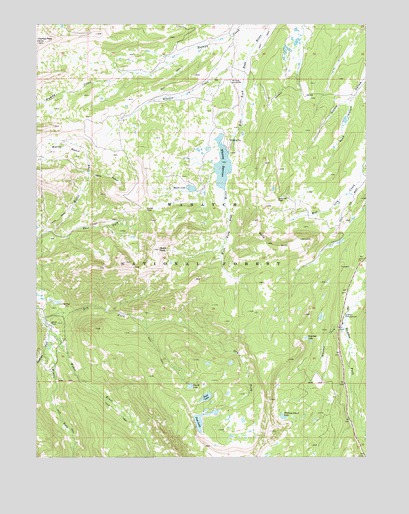
Whitney Reservoir, UT USGS Topographic Map
Click on map above to begin viewing in our Map Viewer.

This topographic map contains these locations and features:
Feature Name Type Latitude Longitude GNIS ID View Map
Beaver LakeLakeN40.8277°W110.9421°1438534View Map
Bourbon LakeReservoirN40.7844°W110.8985°1439043View Map
Carrot HollowValleyN40.8316°W110.9793°1439485View Map
Dry ForkStreamN40.7902°W110.9985°1440621View Map
East Fork Moffit CreekStreamN40.8149°W110.9957°1440813View Map
Fish LakeReservoirN40.7598°W110.9393°1441086View Map
Fish LakeReservoirN40.7599°W110.9307°1447950View Map
Fish Lake DamDamN40.7599°W110.9307°1447951View Map
Gardners ForkStreamN40.7838°W110.9963°1441275View Map
Gold HillSummitN40.8116°W110.9138°1441352View Map
Gold Hill PassGapN40.8247°W110.9093°1441353View Map
Holiday Park PeakSummitN40.7872°W110.8782°1454770View Map
Meadow CreekStreamN40.8636°W110.9213°1443272View Map
Middle Fork Weber RiverStreamN40.7866°W110.9960°1443359View Map
Mill City Ghost TownLocaleN40.8572°W110.9246°1448658View Map
Moffit PassGapN40.8213°W110.9602°1443540View Map
Moffit PeakSummitN40.8097°W110.9546°1443541View Map
Road HollowValleyN40.8536°W110.8810°1445005View Map
Round LakeReservoirN40.7705°W110.9425°1445168View Map
Sand LakeReservoirN40.7674°W110.9366°1445310View Map
Sand Lake DamDamN40.7683°W110.9374°1447955View Map
Summit CountyCivilN40.8682°W110.9559°1448035View Map
Whiskey CreekStreamN40.7872°W110.8838°1447226View Map
Whiskey Island LakeLakeN40.7615°W110.9072°1447230View Map
Whitney Guard StationLocaleN40.8580°W110.9268°1447298View Map
Whitney ReservoirReservoirN40.8346°W110.9302°1447980View Map
Whitney Reservoir DamDamN40.8383°W110.9274°1447981View Map

Note: Coordinates in the location and feature list above are referenced to NAD83 datum.


Copyright (C) 2008-2024 Ryan Niemi / Sunset Dynamics ... All Rights Reserved