TopoQuest Logo
Do you find TopoQuest useful?
Help keep TopoQuest running and adding new maps/features by donating!
Bitcoin:  19c7KJd3qBynnjoSw5npx9KScwjBe4ifkT
Litecoin:  LXs6TkuXGGXo1vDsWCkWVdjQX94eUKd6ui
Home View Maps Find Maps Find Places Resources & Links


Sterling Mountain, Vermont Topographic Map

USGS Map Title: Sterling Mountain, VT
USGS Map MRC: 44072E6
DRG (GeoTIFF) Download: o44072e6.tif


Neighboring USGS Topographic Map Quads:


  Jeffersonville, VT  
44072F7
 

  Johnson, VT  
44072F6
 

  Eden, VT  
44072F5
 

  Mount Mansfield, VT  
44072E7
 

  Sterling Mountain, VT  
44072E6
 

  Morrisville, VT  
44072E5
 

  Bolton Mountain, VT  
44072D7
 

  Stowe, VT  
44072D6
 

  Mount Worcester, VT  
44072D5


Map MRC Location:

N45°
W73°
N45°
W72°
H8 H7 H6 H5 H4 H3 H2 H1
G8 G7 G6 G5 G4 G3 G2 G1
F8 F7 F6 F5 F4 F3 F2 F1
E8 E7 E6 E5 E4 E3 E2 E1
D8 D7 D6 D5 D4 D3 D2 D1
C8 C7 C6 C5 C4 C3 C2 C1
B8 B7 B6 B5 B4 B3 B2 B1
A8 A7 A6 A5 A4 A3 A2 A1
N44°
W73°
N44°
W72°

Sterling Mountain, VT USGS 1:24K Topographic Map Preview:
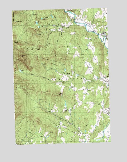
Sterling Mountain, VT USGS Topographic Map
Click on map above to begin viewing in our Map Viewer.

This topographic map contains these locations and features:
Feature Name Type Latitude Longitude GNIS ID View Map
Bahannan BrookStreamN44.5228°W72.6860°1456204View Map
Beaver MeadowLakeN44.5678°W72.7397°1456345View Map
Beaver Meadow BrookStreamN44.5628°W72.6640°1456351View Map
Belding PondLakeN44.6168°W72.7108°1456376View Map
Belding Pond BrookStreamN44.6087°W72.6868°1456377View Map
Bidwell - French Hill CemeteryCemeteryN44.6065°W72.6863°1918291View Map
Boulley BrookStreamN44.6045°W72.7001°1456528View Map
Bull Moose HillSummitN44.5459°W72.6985°1456636View Map
Caper HillSummitN44.5839°W72.6960°1456764View Map
Catholic Youth CampLocaleN44.5181°W72.6773°1918303View Map
Church of the NazareneChurchN44.6126°W72.6565°2059268View Map
Cole SchoolSchoolN44.5384°W72.6662°1456980View Map
Daniels NotchGapN44.5967°W72.7471°1457102View Map
Dry RidgeRidgeN44.6173°W72.7167°1457199View Map
Edson Hill Cross Country Ski CenterLocaleN44.5112°W72.7260°1918323View Map
French Hill BrookStreamN44.6089°W72.6882°1457493View Map
Hall BrookStreamN44.6070°W72.6798°1457695View Map
Harvest Christian SchoolSchoolN44.6234°W72.6595°2427493View Map
Jacob BrookStreamN44.6020°W72.6415°1457985View Map
Johnson Village Municipal ForestForestN44.6131°W72.7015°1918377View Map
Kimibakw DamDamN44.5117°W72.6496°1766739View Map
Lamoille Area Vocational CenterSchoolN44.6013°W72.6307°2427439View Map
Lamoille CountyCivilN44.6057°W72.6414°1461764View Map
Lamoille North Supervisory UnionSchoolN44.6016°W72.6339°2427414View Map
Lamoille Union Middle and High SchoolSchoolN44.6014°W72.6309°2059269View Map
Morristown Bog Natural AreaLocaleN44.5028°W72.6259°1918399View Map
Morristown Bog State ForestForestN44.5042°W72.6259°1918400View Map
Moulds LodgeLocaleN44.5673°W72.7418°1458564View Map
Mountain View CemeteryCemeteryN44.5582°W72.6281°1458592View Map
Mountain View Farm AirportAirportN44.5170°W72.6415°2442749View Map
Mud BrookStreamN44.5589°W72.6735°1458594View Map
Mud City SchoolSchoolN44.5634°W72.6785°1458596View Map
Old Catholic CemeteryCemeteryN44.6225°W72.6701°1918426View Map
Red BridgeBridgeN44.5189°W72.6773°1459153View Map
Ross HillSummitN44.5301°W72.6846°1459248View Map
RoundtopSummitN44.5106°W72.6990°1459266View Map
Sterling CemeteryCemeteryN44.5393°W72.7099°1459694View Map
Sterling CemeteryCemeteryN44.5392°W72.7101°1918454View Map
Sterling MountainSummitN44.5828°W72.7398°1460221View Map
Sterling RangeRangeN44.5598°W72.7473°1459696View Map
Stowe Municipal ForestForestN44.5139°W72.7232°1918464View Map
Terrill HillSummitN44.5851°W72.6351°1459838View Map
Town of MorristownCivilN44.5485°W72.6377°1462154View Map
Waterman BrookStreamN44.6131°W72.6682°1460079View Map
Waterman Covered BridgeBridgeN44.6092°W72.6843°1918483View Map
West SettlementPopulated PlaceN44.6201°W72.7212°1460473View Map
White Face LodgeLocaleN44.5787°W72.7401°1460220View Map
White RocksSummitN44.5737°W72.7310°1460226View Map
WVMX-FM (Stowe)TowerN44.5031°W72.6926°1461906View Map

Note: Coordinates in the location and feature list above are referenced to NAD83 datum.


Copyright (C) 2008-2024 Ryan Niemi / Sunset Dynamics ... All Rights Reserved