TopoQuest Logo
Do you find TopoQuest useful?
Help keep TopoQuest running and adding new maps/features by donating!
Bitcoin:  19c7KJd3qBynnjoSw5npx9KScwjBe4ifkT
Litecoin:  LXs6TkuXGGXo1vDsWCkWVdjQX94eUKd6ui
Home View Maps Find Maps Find Places Resources & Links


Westfield Center, Ohio Topographic Map

USGS Map Title: Westfield Center, OH
USGS Map MRC: 41081A8
DRG (GeoTIFF) Download: o41081a8.tif


Neighboring USGS Topographic Map Quads:


  Lagrange, OH  
41082B1
 

  Mallet Creek, OH  
41081B8
 

  Medina, OH  
41081B7
 

  Lodi, OH  
41082A1
 

  Westfield Center, OH  
41081A8
 

  Seville, OH  
41081A7
 

  West Salem, OH  
40082H1
 

  Creston, OH  
40081H8
 

  Rittman, OH  
40081H7


Map MRC Location:

N42°
W82°
N42°
W81°
H8 H7 H6 H5 H4 H3 H2 H1
G8 G7 G6 G5 G4 G3 G2 G1
F8 F7 F6 F5 F4 F3 F2 F1
E8 E7 E6 E5 E4 E3 E2 E1
D8 D7 D6 D5 D4 D3 D2 D1
C8 C7 C6 C5 C4 C3 C2 C1
B8 B7 B6 B5 B4 B3 B2 B1
A8 A7 A6 A5 A4 A3 A2 A1
N41°
W82°
N41°
W81°

Westfield Center, OH USGS 1:24K Topographic Map Preview:
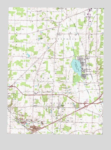
Westfield Center, OH USGS Topographic Map
Click on map above to begin viewing in our Map Viewer.

This topographic map contains these locations and features:
Feature Name Type Latitude Longitude GNIS ID View Map
Baker PitMineN41.0058°W81.9686°2740878View Map
Bethany ChurchChurchN41.1045°W81.9415°1037894View Map
Boy Scout CampLocaleN41.1073°W81.9018°1038235View Map
Briarwood BeachPopulated PlaceN41.0767°W81.8962°1064486View Map
Brookdale Mobile Home ParkPopulated PlaceN41.1183°W81.9025°2486126View Map
Buck CreekStreamN41.0484°W81.8994°2778785View Map
Buckeye Woods County ParkParkN41.1056°W81.9185°1963976View Map
Chippewa Creek Watershed 2A ReservoirReservoirN41.0653°W81.8830°1078701View Map
Chippewa LakePopulated PlaceN41.0698°W81.9010°1802920View Map
Chippewa LakeLakeN41.0669°W81.9098°1039078View Map
Chippewa Lake ParkPopulated PlaceN41.0634°W81.8957°1039079View Map
Chippewa Lake Post OfficePost OfficeN41.0711°W81.8992°2036154View Map
Chippewa-on-the-LakePopulated PlaceN41.0698°W81.9010°1056801View Map
Cloverleaf High SchoolSchoolN41.0407°W81.9644°1039202View Map
Cloverleaf Middle SchoolSchoolN41.0409°W81.9604°1058903View Map
Crazy Bob's AirportAirportN41.0457°W81.9385°1083108View Map
Double R FarmLocaleN41.0572°W81.9664°2710534View Map
FriendsvillePopulated PlaceN41.0273°W81.9657°1064689View Map
Friendsville CemeteryCemeteryN41.0341°W81.9652°1040698View Map
Friendsville Post Office (historical)Post OfficeN41.0278°W81.9651°2036004View Map
Gloria Glens ParkPopulated PlaceN41.0584°W81.8979°1064735View Map
J And M Trailer CourtPopulated PlaceN41.0186°W81.8778°2486134View Map
LafayettePopulated PlaceN41.0992°W81.9351°1061236View Map
Lafayette CemeteryCemeteryN41.0701°W81.9545°1042370View Map
Lafayette Elementary SchoolSchoolN41.1001°W81.9346°1058901View Map
Lafayette Township Fire Department - Station 1BuildingN41.0988°W81.9333°2550027View Map
Lafayette Township Fire Department - Station 2BuildingN41.0706°W81.8995°2550293View Map
M.C.R. AirportAirportN41.0620°W81.9815°1082795View Map
McCabe CreekStreamN41.0723°W81.9076°1048303View Map
McKnight LakeReservoirN41.0776°W81.9733°1078672View Map
McKnight Lake DamDamN41.0767°W81.9715°1078671View Map
Medina CountyCivilN41.1176°W81.8997°1074064View Map
Medina County HomeBuildingN41.0987°W81.9107°1058902View Map
Old Westfield Center CemeteryCemeteryN41.0262°W81.9375°1963500View Map
R Farm LakeLakeN41.0940°W81.9593°1044834View Map
Shaw CemeteryCemeteryN41.0712°W81.9385°1046151View Map
Spitzer CemeteryCemeteryN41.0992°W81.8921°1046533View Map
The InletStreamN41.0737°W81.9096°1047006View Map
Township of LafayetteCivilN41.0976°W81.9305°1086597View Map
Township of WestfieldCivilN41.0033°W81.9285°1086606View Map
Universalist Church of Westfield CenterChurchN41.0276°W81.9338°1069687View Map
Village of Chippewa LakeCivilN41.0737°W81.9047°2397623View Map
Village of Gloria Glens ParkCivilN41.0578°W81.9010°2398981View Map
Village of Westfield CenterCivilN41.0283°W81.9315°2400152View Map
Waltz CemeteryCemeteryN41.1214°W81.9590°1963511View Map
Waltz ChurchChurchN41.1212°W81.9574°1065452View Map
Westfield Airport (historical)AirportN41.0126°W81.9229°1083107View Map
Westfield CenterPopulated PlaceN41.0264°W81.9332°1061761View Map
Westfield Center CemeteryCemeteryN41.0269°W81.9281°1963512View Map
Westfield Center Post OfficePost OfficeN41.0270°W81.9305°2036161View Map
Westfield Elementary SchoolSchoolN41.0256°W81.9326°1058900View Map
Westfield Fire DepartmentBuildingN41.0280°W81.9330°2550023View Map
Wolf LakesReservoirN41.0289°W81.9127°1078670View Map
Wolf Lakes DamDamN41.0284°W81.9115°1078669View Map

Note: Coordinates in the location and feature list above are referenced to NAD83 datum.


Copyright (C) 2008-2024 Ryan Niemi / Sunset Dynamics ... All Rights Reserved