TopoQuest Logo
Do you find TopoQuest useful?
Help keep TopoQuest running and adding new maps/features by donating!
Bitcoin:  19c7KJd3qBynnjoSw5npx9KScwjBe4ifkT
Litecoin:  LXs6TkuXGGXo1vDsWCkWVdjQX94eUKd6ui
Home View Maps Find Maps Find Places Resources & Links


Bodie, Washington Topographic Map

USGS Map Title: Bodie, WA
USGS Map MRC: 48118G8
DRG (GeoTIFF) Download: o48118g8.tif


Neighboring USGS Topographic Map Quads:


  Chesaw, WA  
48119H1
 

  Buckhorn Mountain, WA  
48118H8
 

  Toroda, WA  
48118H7
 

  Mount Bonaparte, WA  
48119G1
 

  Bodie, WA  
48118G8
 

  Bodie Mountain, WA  
48118G7
 

  Mount Annie, WA  
48119F1
 

  Wauconda Summit, WA  
48118F8
 

  Storm King Mountain, WA  
48118F7


Map MRC Location:

N49°
W119°
N49°
W118°
H8 H7 H6 H5 H4 H3 H2 H1
G8 G7 G6 G5 G4 G3 G2 G1
F8 F7 F6 F5 F4 F3 F2 F1
E8 E7 E6 E5 E4 E3 E2 E1
D8 D7 D6 D5 D4 D3 D2 D1
C8 C7 C6 C5 C4 C3 C2 C1
B8 B7 B6 B5 B4 B3 B2 B1
A8 A7 A6 A5 A4 A3 A2 A1
N48°
W119°
N48°
W118°

Bodie, WA USGS 1:24K Topographic Map Preview:
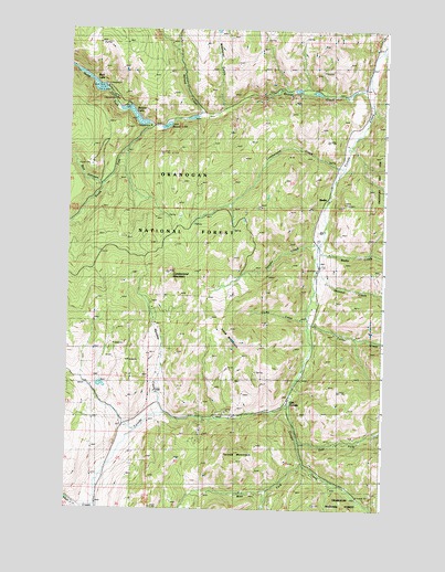
Bodie, WA USGS Topographic Map
Click on map above to begin viewing in our Map Viewer.

This topographic map contains these locations and features:
Feature Name Type Latitude Longitude GNIS ID View Map
Atchison MillLocaleN48.7982°W118.9034°1529763View Map
Beaver CreekStreamN48.8632°W118.8811°1516316View Map
Beaver LakeLakeN48.8524°W118.9747°1516338View Map
Beaver Lake CampgroundLocaleN48.8499°W118.9684°1529765View Map
Beth LakeReservoirN48.8608°W118.9908°1516451View Map
Beth Lake CampgroundLocaleN48.8568°W118.9820°1529764View Map
Beth Lake DamDamN48.8599°W118.9878°1532359View Map
BodiePopulated PlaceN48.8327°W118.8967°1516745View Map
Bodie CreekStreamN48.8191°W118.9006°1516746View Map
Box CanyonValleyN48.8354°W118.9889°1516896View Map
Cache CreekStreamN48.8002°W118.9053°1517200View Map
Cougar CreekStreamN48.7766°W118.9120°1518160View Map
Cumberland CreekStreamN48.8391°W118.8911°1518408View Map
Cumberland MountainSummitN48.8102°W118.9587°1518410View Map
East Fork Cougar CreekStreamN48.7685°W118.9081°1519090View Map
Giveout CreekStreamN48.8121°W118.9011°1519969View Map
Harvey CreekStreamN48.8699°W118.8770°1520592View Map
Irene MountainSummitN48.7946°W118.9325°1521230View Map
Meadow CreekStreamN48.7749°W118.9623°1522959View Map
Milard CreekStreamN48.8521°W118.9484°1523120View Map
North Fork Beaver CreekStreamN48.8491°W118.9659°1523737View Map
Old TorodaPopulated PlaceN48.7777°W118.9114°1524016View Map
South Fork Beaver CreekStreamN48.8493°W118.9659°1526159View Map
Toroda MountainSummitN48.7632°W118.9384°1527316View Map
Turner CreekStreamN48.7988°W118.9045°1527478View Map
Vaughn CreekStreamN48.8191°W118.9006°1527691View Map
Walker CreekStreamN48.7507°W118.9889°1527765View Map
Wauconda QuarryMineN48.7857°W118.9697°2605761View Map
West Fork Cougar CreekStreamN48.7624°W118.9067°1527937View Map
Westphal GulchValleyN48.8554°W118.9389°1528012View Map

Note: Coordinates in the location and feature list above are referenced to NAD83 datum.


Copyright (C) 2008-2024 Ryan Niemi / Sunset Dynamics ... All Rights Reserved