TopoQuest Logo
Do you find TopoQuest useful?
Help keep TopoQuest running and adding new maps/features by donating!
Bitcoin:  19c7KJd3qBynnjoSw5npx9KScwjBe4ifkT
Litecoin:  LXs6TkuXGGXo1vDsWCkWVdjQX94eUKd6ui
Home View Maps Find Maps Find Places Resources & Links


Tuckasegee, North Carolina Topographic Map

USGS Map Title: Tuckasegee, NC
USGS Map MRC: 35083C1
DRG (GeoTIFF) Download: o35083c1.tif


Neighboring USGS Topographic Map Quads:


  Sylva North, NC  
35083D2
 

  Hazelwood, NC  
35083D1
 

  Waynesville, NC  
35082D8
 

  Sylva South, NC  
35083C2
 

  Tuckasegee, NC  
35083C1
 

  Sam Knob, NC  
35082C8
 

  Glenville, NC  
35083B2
 

  Big Ridge, NC  
35083B1
 

  Lake Toxaway, NC  
35082B8


Map MRC Location:

N36°
W84°
N36°
W83°
H8 H7 H6 H5 H4 H3 H2 H1
G8 G7 G6 G5 G4 G3 G2 G1
F8 F7 F6 F5 F4 F3 F2 F1
E8 E7 E6 E5 E4 E3 E2 E1
D8 D7 D6 D5 D4 D3 D2 D1
C8 C7 C6 C5 C4 C3 C2 C1
B8 B7 B6 B5 B4 B3 B2 B1
A8 A7 A6 A5 A4 A3 A2 A1
N35°
W84°
N35°
W83°

Tuckasegee, NC USGS 1:24K Topographic Map Preview:
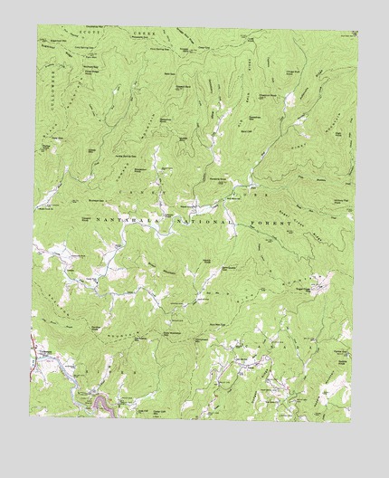
Tuckasegee, NC USGS Topographic Map
Click on map above to begin viewing in our Map Viewer.

This topographic map contains these locations and features:
Feature Name Type Latitude Longitude GNIS ID View Map
Abbs CreekStreamN35.3112°W83.0771°980016View Map
ArguraPopulated PlaceN35.2676°W83.0410°1018849View Map
Bald CliffCliffN35.3432°W83.0440°980461View Map
Bald GapGapN35.3598°W83.0704°980464View Map
Balsam Grove ChurchChurchN35.3184°W83.0615°980505View Map
Bearwallow CreekStreamN35.3270°W83.0026°1009050View Map
Beechflat CreekStreamN35.3409°W83.0296°980913View Map
Birch Ridge CreekStreamN35.3315°W83.0007°1009412View Map
Black MountainSummitN35.3604°W83.1068°1019199View Map
Brasstown CemeteryCemeteryN35.3293°W83.0757°981839View Map
Brasstown KnobSummitN35.3293°W83.0868°1019282View Map
Broom CemeteryCemeteryN35.2743°W83.0446°981990View Map
Brown CemeteryCemeteryN35.2815°W83.0710°982000View Map
Brown CemeteryCemeteryN35.3045°W83.0924°982001View Map
Brown MountainSummitN35.2968°W83.0676°1019321View Map
Buckeye GapGapN35.3190°W83.0974°982126View Map
Canada Volunteer Fire DepartmentBuildingN35.2617°W83.0261°2639123View Map
Caney Fork SchoolSchoolN35.2932°W83.0996°982606View Map
Canoe CreekStreamN35.2543°W83.1046°1010024View Map
Catherine ChapelChurchN35.3151°W83.0743°982760View Map
Cathey CemeteryCemeteryN35.2518°W83.0279°982762View Map
Cedar Cliff ChurchChurchN35.2523°W83.0826°982803View Map
Cedar Cliff DamDamN35.2531°W83.0993°998666View Map
Cedar Cliff MountainSummitN35.2509°W83.0765°1019573View Map
Cedar Valley CreekStreamN35.2534°W83.0924°1988108View Map
Cedar Valley KnobSummitN35.2540°W83.0649°1988107View Map
Cedar Valley SpringSpringN35.2734°W83.0654°1988110View Map
Chastine CreekStreamN35.3159°W83.0610°983057View Map
Chestnut KnobSummitN35.3532°W83.0382°983111View Map
Chestnut Ridge CreekStreamN35.3368°W83.0015°1010270View Map
Choga Butt KnobSummitN35.3615°W83.0282°1019672View Map
Cold Spring GapGapN35.3676°W83.1026°983353View Map
Coppermine CreekStreamN35.3532°W83.0279°983533View Map
Coward BaldSummitN35.3554°W83.0707°983646View Map
Coward CemeteryCemeteryN35.2868°W83.0660°983647View Map
Coward KnobSummitN35.3132°W83.1071°1023453View Map
Coward MountainSummitN35.3348°W83.0840°1023454View Map
CowartsPopulated PlaceN35.2970°W83.1121°1019818View Map
Craig CreekStreamN35.3459°W83.0532°983701View Map
Cullowhee Volunteer Fire Department Station 2BuildingN35.2637°W83.1249°2639113View Map
Cullowhee Volunteer Fire Department Station 3BuildingN35.2952°W83.0987°2639118View Map
Deep GapGapN35.3395°W83.1185°984073View Map
Deep GapGapN35.3682°W83.0576°984074View Map
Dodgen RidgeRidgeN35.2509°W83.0390°1010848View Map
Doubletop MountainSummitN35.2762°W83.0846°1020018View Map
Dryland Laurel BranchStreamN35.3098°W83.0371°984371View Map
East Fork Moses CreekStreamN35.3418°W83.0946°984504View Map
Fern MountainSummitN35.3662°W83.1046°985055View Map
Flint Spring GapGapN35.3684°W83.0738°985223View Map
Frady CreekStreamN35.3362°W83.0562°985361View Map
Gooseberry RidgeRidgeN35.3523°W83.0576°985832View Map
Hawkins KnobSummitN35.3257°W83.0537°986530View Map
Hench KnobSummitN35.3007°W83.0549°1020678View Map
Hickory Flat KnobSummitN35.3204°W83.0085°1020702View Map
High KnobSummitN35.3426°W83.0093°1020738View Map
Hornyhead MountainSummitN35.2759°W83.0618°1020836View Map
Indian Camp BranchStreamN35.3445°W83.0979°987337View Map
Jackie Spring GapGapN35.3332°W83.0849°987470View Map
Jeff CreekStreamN35.2682°W83.0182°987540View Map
Johns CreekStreamN35.2918°W83.1021°987645View Map
Judaculla RidgeRidgeN35.3579°W83.0168°987801View Map
Judaculla RockPillarN35.3009°W83.1099°987802View Map
Lost KnobSummitN35.3726°W83.0435°989034View Map
Mathis CemeteryCemeteryN35.2754°W83.0321°989459View Map
Mayapple GapGapN35.3712°W83.0826°989499View Map
Moffitt MountainSummitN35.3398°W83.0693°1021508View Map
Moses Creek ChurchChurchN35.3165°W83.1226°990285View Map
Mull CreekStreamN35.3251°W83.0412°1013837View Map
Neddie KnobSummitN35.2690°W83.0060°1021609View Map
Old Bald RidgeRidgeN35.3690°W83.0412°1014088View Map
Panther KnobSummitN35.2787°W83.1018°1021792View Map
Parker GapGapN35.2723°W83.0012°991864View Map
Parker KnobSummitN35.3354°W83.1224°991867View Map
Piney MountainSummitN35.3559°W83.0001°1021961View Map
Piney Mountain CreekStreamN35.3248°W83.0268°1014458View Map
Piney Ridge KnobSummitN35.3607°W83.1065°1021975View Map
Polly Middleton GapGapN35.2773°W83.0743°992651View Map
Queen CemeteryCemeteryN35.2884°W83.0604°992942View Map
Rich MountainPopulated PlaceN35.3223°W83.0460°1022258View Map
Rich Mountain BranchStreamN35.2909°W83.0593°993298View Map
Rich Mountain GapGapN35.2801°W83.0490°993301View Map
Rough Butt CreekStreamN35.3248°W83.0268°1015097View Map
Roy Taylor ForestParkN35.2993°W83.0140°1018061View Map
Sam Queen GapGapN35.2984°W83.0515°994204View Map
Sassafras GapGapN35.3468°W83.0424°994354View Map
Sassafras KnobSummitN35.3451°W83.0779°1022508View Map
Sheep MountainSummitN35.3354°W83.1046°1022574View Map
Shelton MountainSummitN35.2762°W83.0849°1022591View Map
Smook CemeteryCemeteryN35.2562°W83.0896°1008290View Map
Snaggy BaldSummitN35.3679°W83.0651°995037View Map
Sols Creek CemeteryCemeteryN35.2598°W83.0285°995106View Map
Sols Creek ChurchChurchN35.2565°W83.0282°995107View Map
Sols Creek ChurchChurchN35.2601°W83.0285°995108View Map
Stephenson CemeteryCemeteryN35.3173°W83.1196°995468View Map
Sugar CreekStreamN35.3207°W83.0510°995643View Map
Sugar Creek GapGapN35.2920°W83.0160°995648View Map
Sugar Creek RidgeRidgeN35.3098°W83.0199°995649View Map
Sugarloaf MountainSummitN35.3698°W83.1210°995656View Map
Sugarloaf RidgeRidgeN35.3698°W83.1243°995659View Map
Township of Caney ForkCivilN35.3264°W83.0539°1026830View Map
Township of RiverCivilN35.2603°W83.1163°1026838View Map
TuckasegeePopulated PlaceN35.2704°W83.1226°996296View Map
Tuckasegee Post OfficePost OfficeN35.2698°W83.1223°2773901View Map
West Fork Moses CreekStreamN35.3418°W83.0946°997017View Map
West Fork Tuckasegee RiverStreamN35.2682°W83.1229°1016543View Map
Wolfpen GapGapN35.3620°W83.1068°997553View Map
Woodring CemeteryCemeteryN35.2670°W83.1076°997604View Map
Woods BranchStreamN35.2573°W83.1082°997607View Map

Note: Coordinates in the location and feature list above are referenced to NAD83 datum.


Copyright (C) 2008-2024 Ryan Niemi / Sunset Dynamics ... All Rights Reserved