TopoQuest Logo
Do you find TopoQuest useful?
Help keep TopoQuest running and adding new maps/features by donating!
Bitcoin:  19c7KJd3qBynnjoSw5npx9KScwjBe4ifkT
Litecoin:  LXs6TkuXGGXo1vDsWCkWVdjQX94eUKd6ui
Home View Maps Find Maps Find Places Resources & Links


Trafford, Alabama Topographic Map

USGS Map Title: Trafford, AL
USGS Map MRC: 33086G6
DRG (GeoTIFF) Download: o33086g6.tif


Neighboring USGS Topographic Map Quads:


  Blount Springs, AL  
33086H7
 

  Nectar, AL  
33086H6
 

  Cleveland, AL  
33086H5
 

  Warrior, AL  
33086G7
 

  Trafford, AL  
33086G6
 

  Remlap, AL  
33086G5
 

  Gardendale, AL  
33086F7
 

  Pinson, AL  
33086F6
 

  Argo, AL  
33086F5


Map MRC Location:

N34°
W87°
N34°
W86°
H8 H7 H6 H5 H4 H3 H2 H1
G8 G7 G6 G5 G4 G3 G2 G1
F8 F7 F6 F5 F4 F3 F2 F1
E8 E7 E6 E5 E4 E3 E2 E1
D8 D7 D6 D5 D4 D3 D2 D1
C8 C7 C6 C5 C4 C3 C2 C1
B8 B7 B6 B5 B4 B3 B2 B1
A8 A7 A6 A5 A4 A3 A2 A1
N33°
W87°
N33°
W86°

Trafford, AL USGS 1:24K Topographic Map Preview:
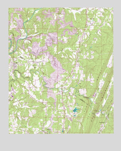
Trafford, AL USGS Topographic Map
Click on map above to begin viewing in our Map Viewer.

This topographic map contains these locations and features:
Feature Name Type Latitude Longitude GNIS ID View Map
Bethel United Methodist ChurchChurchN33.7945°W86.7092°114069View Map
Bethlehem ChurchChurchN33.8420°W86.6628°114137View Map
Black Creek Number 1 MineMineN33.8362°W86.7264°135076View Map
BradfordPopulated PlaceN33.7520°W86.7039°114804View Map
Bradford ChurchChurchN33.7529°W86.6992°144022View Map
Bradford Slope MineMineN33.7668°W86.7180°146136View Map
Bradford United Methodist ChurchChurchN33.7518°W86.7044°151313View Map
BrentwoodPopulated PlaceN33.7773°W86.6292°135083View Map
Cedar SpringsPopulated PlaceN33.8640°W86.6544°115815View Map
ComptonPopulated PlaceN33.8173°W86.6278°135089View Map
County LinePopulated PlaceN33.8215°W86.7186°116712View Map
County Line Missionary Baptist ChurchChurchN33.8209°W86.7197°1700533View Map
County Line Town HallBuildingN33.8201°W86.7294°1700537View Map
Creel CemeteryCemeteryN33.7590°W86.7489°144118View Map
Cumberland DamDamN33.7718°W86.6733°131731View Map
DallasPopulated PlaceN33.8495°W86.6605°117019View Map
Dallas - Selfville Volunteer Fire DepartmentBuildingN33.8398°W86.6654°135165View Map
Dallas ChurchChurchN33.8518°W86.6594°135093View Map
Dean GapGapN33.7607°W86.6644°163274View Map
Deans Ferry BridgeBridgeN33.8462°W86.7283°117180View Map
Dixiana Post OfficePost OfficeN33.7520°W86.7039°1721319View Map
Dry CreekStreamN33.8348°W86.6814°117579View Map
Good News ChurchChurchN33.7993°W86.6761°163861View Map
GurleyPopulated PlaceN33.7765°W86.6378°135099View Map
Gurley Creek GapGapN33.7859°W86.6569°135100View Map
Hayes CreekStreamN33.8626°W86.7261°119888View Map
Higginbothams LakeReservoirN33.7642°W86.6759°131727View Map
Holston ChapelChurchN33.8245°W86.7236°120294View Map
Hopewell ChurchChurchN33.7676°W86.6817°120380View Map
Hopewell LakeDamN33.7651°W86.6767°131728View Map
Huffstufer MineMineN33.8723°W86.6972°135110View Map
Hughes CemeteryCemeteryN33.7529°W86.7314°120532View Map
Hughes ChapelChurchN33.7526°W86.7080°120533View Map
Indio MineMineN33.8251°W86.7472°146135View Map
Jefferson Hughes ChurchChurchN33.7593°W86.7094°144310View Map
Johns MineMineN33.8709°W86.6917°135115View Map
Johnson Elementary SchoolSchoolN33.7518°W86.6983°144316View Map
Kelly CreekStreamN33.8459°W86.7280°121121View Map
Kimberly-Morris DivisionCivilN33.7707°W86.7449°165820View Map
KiowaPopulated PlaceN33.7993°W86.6672°156563View Map
Lake SueannReservoirN33.7735°W86.6703°153596View Map
Lake Sueann DamDamN33.7684°W86.6717°131730View Map
LehighPopulated PlaceN33.8543°W86.6839°135119View Map
Lilly ChapelChurchN33.8165°W86.7189°121619View Map
Lilly Chapel CemeteryCemeteryN33.8209°W86.7019°152061View Map
Little White CreekStreamN33.8740°W86.6255°121908View Map
Locust Fork DivisionCivilN33.8481°W86.6435°165665View Map
Longs BranchStreamN33.8370°W86.7400°152151View Map
Longs FordCrossingN33.8468°W86.7286°154097View Map
MasseylinePopulated PlaceN33.7918°W86.6861°152244View Map
Masseyline ChurchChurchN33.7912°W86.6842°1700540View Map
Murphree ValleyValleyN33.7684°W86.6325°123598View Map
NyotaPopulated PlaceN33.8501°W86.7453°156810View Map
Nyota MineMineN33.8557°W86.7444°135139View Map
Nyota MineMineN33.8320°W86.7125°135140View Map
Philadelphia ChurchChurchN33.8687°W86.6875°124676View Map
Pleasant Grove ChurchChurchN33.8451°W86.7005°124963View Map
Red Valley BranchStreamN33.7723°W86.6405°153122View Map
Remlap Volunteer Fire Department Station 2BuildingN33.7699°W86.6348°2682656View Map
Revelation ChurchChurchN33.8532°W86.6597°163867View Map
Rio Dell MineMineN33.8404°W86.7486°135155View Map
Sand RidgeRidgeN33.7915°W86.6450°126324View Map
Sand Valley CreekStreamN33.7843°W86.6517°153320View Map
Self CreekStreamN33.8345°W86.6811°135162View Map
SelfvillePopulated PlaceN33.8304°W86.6680°153368View Map
Selfville ChurchChurchN33.8226°W86.6680°153369View Map
Selfville ChurchChurchN33.8451°W86.6433°135164View Map
Smith Mill (historical)LocaleN33.8068°W86.7105°140303View Map
South Carbon MineMineN33.8251°W86.7194°135172View Map
Spring Valley LakesReservoirN33.7734°W86.6406°127272View Map
Sterling SchoolSchoolN33.8412°W86.6647°127363View Map
SueannPopulated PlaceN33.7704°W86.6703°157123View Map
The NarrowsGapN33.7857°W86.6567°127826View Map
Thermal (historical)Populated PlaceN33.8140°W86.7258°140337View Map
Thermal Number 1 MineMineN33.8251°W86.7139°135185View Map
Town of County LineCivilN33.8209°W86.7197°2406322View Map
Town of TraffordCivilN33.8195°W86.7466°2406747View Map
TraffordPopulated PlaceN33.8182°W86.7428°153714View Map
Trafford Baptist ChurchChurchN33.8193°W86.7447°1700543View Map
Trafford Church of GodChurchN33.8251°W86.7472°1700544View Map
Trafford City HallBuildingN33.8190°W86.7425°1700545View Map
Trafford Elementary SchoolSchoolN33.8187°W86.7328°140344View Map
Trafford Fire DepartmentBuildingN33.8172°W86.7420°2682934View Map
Trafford Police DepartmentBuildingN33.8193°W86.7425°2752069View Map
Trafford Post OfficePost OfficeN33.8218°W86.7478°1700546View Map
Upper Creek MineMineN33.8404°W86.7361°135186View Map
Vandiver CemeteryCemeteryN33.8226°W86.7100°128409View Map
Village SpringsPopulated PlaceN33.7584°W86.6386°128454View Map
Village Springs CemeteryCemeteryN33.7720°W86.6339°128455View Map
Village Springs ChurchChurchN33.7529°W86.6403°140372View Map
Wilson Number 1 MineMineN33.8682°W86.6930°135188View Map
WoodhavenPopulated PlaceN33.7701°W86.6267°135189View Map
Worthington Ore MinesMineN33.7945°W86.6383°151452View Map
Youngblood ChapelChurchN33.8640°W86.6550°135191View Map

Note: Coordinates in the location and feature list above are referenced to NAD83 datum.


Copyright (C) 2008-2024 Ryan Niemi / Sunset Dynamics ... All Rights Reserved