TopoQuest Logo
Do you find TopoQuest useful?
Help keep TopoQuest running and adding new maps/features by donating!
Bitcoin:  19c7KJd3qBynnjoSw5npx9KScwjBe4ifkT
Litecoin:  LXs6TkuXGGXo1vDsWCkWVdjQX94eUKd6ui
Home View Maps Find Maps Find Places Resources & Links


Toomsboro, Georgia Topographic Map

USGS Map Title: Toomsboro, GA
USGS Map MRC: 32083G1
DRG (GeoTIFF) Download: o32083g1.tif


Neighboring USGS Topographic Map Quads:


  Napier Pond, GA  
32083H2
 

  Gumm Pond, GA  
32083H1
 

  Tabernacle, GA  
32082H8
 

  Irwinton, GA  
32083G2
 

  Toomsboro, GA  
32083G1
 

  Oconee, GA  
32082G8
 

  Stuckey Boone Lake, GA  
32083F2
 

  Nicklesville, GA  
32083F1
 

  Cow Hell Swamp, GA  
32082F8


Map MRC Location:

N33°
W84°
N33°
W83°
H8 H7 H6 H5 H4 H3 H2 H1
G8 G7 G6 G5 G4 G3 G2 G1
F8 F7 F6 F5 F4 F3 F2 F1
E8 E7 E6 E5 E4 E3 E2 E1
D8 D7 D6 D5 D4 D3 D2 D1
C8 C7 C6 C5 C4 C3 C2 C1
B8 B7 B6 B5 B4 B3 B2 B1
A8 A7 A6 A5 A4 A3 A2 A1
N32°
W84°
N32°
W83°

Toomsboro, GA USGS 1:24K Topographic Map Preview:
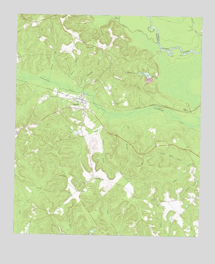
Toomsboro, GA USGS Topographic Map
Click on map above to begin viewing in our Map Viewer.

This topographic map contains these locations and features:
Feature Name Type Latitude Longitude GNIS ID View Map
Beech HillPopulated PlaceN32.8224°W83.0090°354527View Map
Big BranchStreamN32.8190°W83.0468°311322View Map
Black CreekStreamN32.8602°W83.0293°311475View Map
Branan-Kinny CemeteryCemeteryN32.8621°W83.1088°346779View Map
Buckhorn LakeReservoirN32.8418°W83.0369°311984View Map
Buckhorn Lake DamDamN32.8407°W83.0332°336113View Map
Camp CreekStreamN32.8199°W83.0601°312213View Map
City of ToomsboroCivilN32.8224°W83.0826°2405596View Map
Collins CemeteryCemeteryN32.8379°W83.0532°346783View Map
David Clay CemeteryCemeteryN32.8663°W83.1090°346786View Map
Ebenezer CemeteryCemeteryN32.7801°W83.0760°346788View Map
Ebenezer ChurchChurchN32.7796°W83.0760°313830View Map
Edmonds BranchStreamN32.8315°W83.0799°313857View Map
Hall LakeReservoirN32.7518°W83.0732°336122View Map
Hall Lake DamDamN32.7518°W83.0732°336121View Map
Kemp School (historical)SchoolN32.7621°W83.0990°334931View Map
Lake JacksonLakeN32.8738°W83.0585°316023View Map
Liberty School (historical)SchoolN32.8424°W83.0799°334933View Map
Little Oochee CreekStreamN32.7918°W83.0071°317139View Map
Lords CemeteryCemeteryN32.7826°W83.0454°317409View Map
Myrtle Springs ChurchChurchN32.7824°W83.0663°319185View Map
Pearson BranchStreamN32.8379°W83.1021°320323View Map
Philadelphia ChurchChurchN32.8482°W83.0607°346809View Map
Poplar Head School (historical)SchoolN32.7718°W83.0435°334934View Map
Poplar Springs CemeteryCemeteryN32.7829°W83.0899°346811View Map
Poplar Springs ChurchChurchN32.7832°W83.0902°321044View Map
Salters BranchStreamN32.8327°W83.0876°322383View Map
Stevens-Cason CemeteryCemeteryN32.8251°W83.0543°323596View Map
Thompson LakeReservoirN32.8085°W83.0832°336116View Map
Thompson Lake DamDamN32.8085°W83.0832°336115View Map
ToomsboroPopulated PlaceN32.8268°W83.0793°324226View Map
Toomsboro DivisionCivilN32.8014°W83.0489°1936593View Map
Toomsboro Police DepartmentBuildingN32.8257°W83.0796°2733707View Map
Toomsboro Volunteer Fire DepartmentBuildingN32.8257°W83.0795°2604776View Map
Union Hill ChurchChurchN32.7682°W83.0279°324569View Map
Union Hill School (historical)SchoolN32.7682°W83.0276°334938View Map
Union School (historical)SchoolN32.7996°W83.0104°334939View Map
Wildcat BranchStreamN32.8088°W83.0688°325267View Map
William H Freeman Memorial BridgeBridgeN32.8124°W83.0663°346830View Map
Woodlawn School (historical)SchoolN32.8482°W83.0607°334940View Map

Note: Coordinates in the location and feature list above are referenced to NAD83 datum.


Copyright (C) 2008-2024 Ryan Niemi / Sunset Dynamics ... All Rights Reserved