TopoQuest Logo
Do you find TopoQuest useful?
Help keep TopoQuest running and adding new maps/features by donating!
Bitcoin:  19c7KJd3qBynnjoSw5npx9KScwjBe4ifkT
Litecoin:  LXs6TkuXGGXo1vDsWCkWVdjQX94eUKd6ui
Home View Maps Find Maps Find Places Resources & Links


Tingles Island, Maryland Topographic Map

USGS Map Title: Tingles Island, MD
USGS Map MRC: 38075B2
DRG (GeoTIFF) Download: o38075b2.tif


Neighboring USGS Topographic Map Quads:


  Berlin, MD  
38075C2
 

  Ocean City, MD  
38075C1
 

  Public Landing, MD  
38075B3
 

  Tingles Island, MD  
38075B2


  Boxiron, MD  
38075A3
 

  Whittington Point, MD  
38075A2


Map MRC Location:

N39°
W76°
N39°
W75°
H8 H7 H6 H5 H4 H3 H2 H1
G8 G7 G6 G5 G4 G3 G2 G1
F8 F7 F6 F5 F4 F3 F2 F1
E8 E7 E6 E5 E4 E3 E2 E1
D8 D7 D6 D5 D4 D3 D2 D1
C8 C7 C6 C5 C4 C3 C2 C1
B8 B7 B6 B5 B4 B3 B2 B1
A8 A7 A6 A5 A4 A3 A2 A1
N38°
W76°
N38°
W75°

Tingles Island, MD USGS 1:24K Topographic Map Preview:
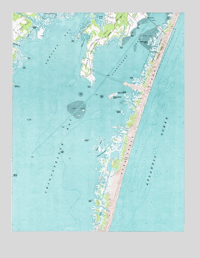
Tingles Island, MD USGS Topographic Map
Click on map above to begin viewing in our Map Viewer.

This topographic map contains these locations and features:
Feature Name Type Latitude Longitude GNIS ID View Map
Assateague State ParkParkN38.2293°W75.1435°582950View Map
Bassett CreekStreamN38.2421°W75.2246°583051View Map
Bayside CampgroundLocaleN38.2062°W75.1566°1668818View Map
Beacon Clumps (historical)IslandN38.1396°W75.2082°1668820View Map
Catbird CreekStreamN38.2476°W75.2294°583620View Map
Cropper CreekStreamN38.2337°W75.2391°583979View Map
Cropper IslandIslandN38.2382°W75.2296°1668865View Map
Cropper PondLakeN38.2405°W75.2330°583981View Map
Crow TumpIslandN38.1696°W75.1935°1668866View Map
District 10, Ocean City (historical)CivilN38.2085°W75.1606°1929441View Map
District 3, SinepuxentCivilN38.1963°W75.1501°1929575View Map
Genezer EstatesPopulated PlaceN38.2246°W75.1930°1668885View Map
Gibbs PondLakeN38.2473°W75.1849°584584View Map
Goose PointCapeN38.2126°W75.1610°584660View Map
Great Egging BeachBeachN38.2021°W75.1769°584724View Map
Great Egging IslandIslandN38.2029°W75.1771°1668893View Map
Green PointCapeN38.2315°W75.1705°584745View Map
Green Point CreekStreamN38.2326°W75.1738°1668895View Map
Island PointCapeN38.2140°W75.1996°588866View Map
Knot PointCapeN38.2337°W75.2038°585329View Map
Little Egging BeachBeachN38.2032°W75.1674°585459View Map
Little Egging IslandIslandN38.2026°W75.1669°1668931View Map
Log PointCapeN38.2190°W75.2430°585548View Map
Lower Sinepuxent NeckCapeN38.2459°W75.1710°585626View Map
Lumber MarshSwampN38.1934°W75.1698°585637View Map
Lumber Marsh IslandIslandN38.1932°W75.1699°1668934View Map
Marshall CreekStreamN38.2304°W75.2427°585706View Map
Newport BayBayN38.2337°W75.2149°586182View Map
Newport NeckCapeN38.2407°W75.1938°586187View Map
Newport SouthPopulated PlaceN38.2357°W75.1885°1668969View Map
North Beach CampgroundLocaleN38.2007°W75.1541°1668972View Map
Out PointCapeN38.2240°W75.2396°586364View Map
Outward TumpIslandN38.1773°W75.1980°586365View Map
Peters NeckCapeN38.2490°W75.2221°586491View Map
Porter CreekStreamN38.2448°W75.2296°586673View Map
Robins MarshSwampN38.1555°W75.2494°586854View Map
Rum PointCapeN38.2373°W75.1641°586959View Map
Rum Pointe Golf CourseLocaleN38.2447°W75.1641°2503620View Map
Salt PointCapeN38.2418°W75.1596°587171View Map
Sandy PointCapeN38.2473°W75.1521°587205View Map
Sandy Point IslandIslandN38.2329°W75.1507°587214View Map
South PointCapeN38.2085°W75.1916°587465View Map
Spence CoveBayN38.2332°W75.1985°587488View Map
Tingles IslandIslandN38.1740°W75.1866°587811View Map
Tingles NarrowsChannelN38.1693°W75.1849°587812View Map
Winter QuarterLocaleN38.1407°W75.1857°1669092View Map

Note: Coordinates in the location and feature list above are referenced to NAD83 datum.


Copyright (C) 2008-2024 Ryan Niemi / Sunset Dynamics ... All Rights Reserved