TopoQuest Logo
Do you find TopoQuest useful?
Help keep TopoQuest running and adding new maps/features by donating!
Bitcoin:  19c7KJd3qBynnjoSw5npx9KScwjBe4ifkT
Litecoin:  LXs6TkuXGGXo1vDsWCkWVdjQX94eUKd6ui
Home View Maps Find Maps Find Places Resources & Links


Timber, Oregon Topographic Map

USGS Map Title: Timber, OR
USGS Map MRC: 45123F3
DRG (GeoTIFF) Download: o45123f3.tif


Neighboring USGS Topographic Map Quads:


  Sunset Spring, OR  
45123G4
 

  Clear Creek, OR  
45123G3
 

  Vernonia, OR  
45123G2
 

  Cochran, OR  
45123F4
 

  Timber, OR  
45123F3
 

  Buxton, OR  
45123F2
 

  Woods Point, OR  
45123E4
 

  Roaring Creek, OR  
45123E3
 

  Gales Creek, OR  
45123E2


Map MRC Location:

N46°
W124°
N46°
W123°
H8 H7 H6 H5 H4 H3 H2 H1
G8 G7 G6 G5 G4 G3 G2 G1
F8 F7 F6 F5 F4 F3 F2 F1
E8 E7 E6 E5 E4 E3 E2 E1
D8 D7 D6 D5 D4 D3 D2 D1
C8 C7 C6 C5 C4 C3 C2 C1
B8 B7 B6 B5 B4 B3 B2 B1
A8 A7 A6 A5 A4 A3 A2 A1
N45°
W124°
N45°
W123°

Timber, OR USGS 1:24K Topographic Map Preview:
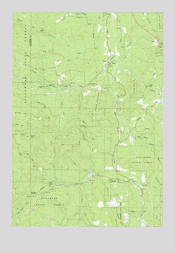
Timber, OR USGS Topographic Map
Click on map above to begin viewing in our Map Viewer.

This topographic map contains these locations and features:
Feature Name Type Latitude Longitude GNIS ID View Map
Banks Fire Protection District 13 Timber StationBuildingN45.7158°W123.3009°2576872View Map
Bauer DamDamN45.6665°W123.2762°1131524View Map
Bauer ReservoirReservoirN45.6754°W123.2770°1131525View Map
Beaver CreekStreamN45.6462°W123.2682°1117431View Map
Burnt Woods Post Office (historical)Post OfficeN45.6748°W123.2859°1164244View Map
Carlson CreekStreamN45.7262°W123.3157°1118612View Map
Castor CreekStreamN45.7382°W123.2829°1118673View Map
Castor Creek (historical)LocaleN45.7109°W123.2907°1166511View Map
Coffee CreekStreamN45.6548°W123.3048°1119077View Map
Consolidated Timber Company Camp (historical)LocaleN45.6559°W123.3112°1162615View Map
East Portland Lumber Company (historical)LocaleN45.7115°W123.3673°1166483View Map
Fernwood (historical)LocaleN45.7037°W123.3332°1166515View Map
Finger CreekStreamN45.6543°W123.3084°1120711View Map
Fir Post Office (historical)Post OfficeN45.6273°W123.2757°1164359View Map
Gales Creek CampgroundParkN45.6434°W123.3582°1121039View Map
Gales Creek Childrens CampLocaleN45.6509°W123.2882°1121038View Map
GlenwoodPopulated PlaceN45.6493°W123.2709°1637846View Map
Glenwood Post OfficePost OfficeN45.6493°W123.2709°1165319View Map
Grays Spur (historical)LocaleN45.6321°W123.2682°1637755View Map
Hudleson SpringSpringN45.7290°W123.2984°1130048View Map
Hulbert (historical)LocaleN45.7232°W123.2873°1166516View Map
Low Divide CreekStreamN45.6426°W123.3573°1123543View Map
North Fork Gales CreekStreamN45.6504°W123.3379°1124745View Map
North Fork Lousignont CreekStreamN45.7448°W123.3037°1124788View Map
Reeher CCC Camp (historical)LocaleN45.7082°W123.3234°1162614View Map
Reehers CampParkN45.7065°W123.3326°1125931View Map
Round TopSummitN45.6773°W123.3621°1126337View Map
South Fork Gales CreekStreamN45.6498°W123.3198°1127284View Map
South Fork Industry Track (historical)LocaleN45.6393°W123.2665°1637756View Map
Step CreekStreamN45.7048°W123.3326°1127592View Map
Sunset Tunnel 2552TunnelN45.7306°W123.2521°1127759View Map
TimberPopulated PlaceN45.7198°W123.2946°1128100View Map
Timber Post OfficePost OfficeN45.7198°W123.2958°1166048View Map
Treen (historical)LocaleN45.7146°W123.2796°1166522View Map
Walcott (historical)LocaleN45.7079°W123.2673°1166523View Map
Walcott TunnelTunnelN45.7069°W123.2637°1158539View Map
WedeburgLocaleN45.7059°W123.3537°1128766View Map
Weist (historical)LocaleN45.7121°W123.3698°1166506View Map
Westimber (historical)Populated PlaceN45.7082°W123.3109°1166721View Map
Westimber Post Office (historical)Post OfficeN45.7082°W123.3109°1166159View Map

Note: Coordinates in the location and feature list above are referenced to NAD83 datum.


Copyright (C) 2008-2024 Ryan Niemi / Sunset Dynamics ... All Rights Reserved