TopoQuest Logo
Do you find TopoQuest useful?
Help keep TopoQuest running and adding new maps/features by donating!
Bitcoin:  19c7KJd3qBynnjoSw5npx9KScwjBe4ifkT
Litecoin:  LXs6TkuXGGXo1vDsWCkWVdjQX94eUKd6ui
Home View Maps Find Maps Find Places Resources & Links


Tiger, Georgia Topographic Map

USGS Map Title: Tiger, GA
USGS Map MRC: 34083G4
DRG (GeoTIFF) Download: o34083g4.tif


Neighboring USGS Topographic Map Quads:


  Hightower Bald, GA  
34083H5
 

  Dillard, GA  
34083H4
 

  Rabun Bald, GA  
34083H3
 

  Lake Burton, GA  
34083G5
 

  Tiger, GA  
34083G4
 

  Rainy Mountain, GA  
34083G3
 

  Clarkesville NE, GA  
34083F5
 

  Tallulah Falls, GA  
34083F4
 

  Tugaloo Lake, GA  
34083F3


Map MRC Location:

N35°
W84°
N35°
W83°
H8 H7 H6 H5 H4 H3 H2 H1
G8 G7 G6 G5 G4 G3 G2 G1
F8 F7 F6 F5 F4 F3 F2 F1
E8 E7 E6 E5 E4 E3 E2 E1
D8 D7 D6 D5 D4 D3 D2 D1
C8 C7 C6 C5 C4 C3 C2 C1
B8 B7 B6 B5 B4 B3 B2 B1
A8 A7 A6 A5 A4 A3 A2 A1
N34°
W84°
N34°
W83°

Tiger, GA USGS 1:24K Topographic Map Preview:
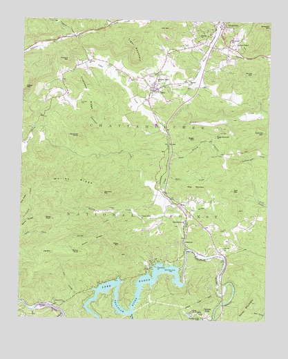
Tiger, GA USGS Topographic Map
Click on map above to begin viewing in our Map Viewer.

This topographic map contains these locations and features:
Feature Name Type Latitude Longitude GNIS ID View Map
Athens Y M C A CampLocaleN34.7531°W83.4127°326975View Map
Athens YMCA Camp DamDamN34.7518°W83.4116°339228View Map
Athens YMCA Camp LakeReservoirN34.7521°W83.4139°339229View Map
Bee Branch RidgeRidgeN34.8448°W83.4407°351462View Map
Bethel ChurchChurchN34.8487°W83.4154°354633View Map
Big Creek Flying Ranch AirportAirportN34.8327°W83.4111°351712View Map
Blalock LakeReservoirN34.8034°W83.3999°337147View Map
Blalock Lake DamDamN34.8034°W83.3999°337146View Map
Boen CreekStreamN34.8059°W83.4268°327190View Map
Boggs BranchStreamN34.8156°W83.4252°327192View Map
Boggs MountainSummitN34.8259°W83.4116°331200View Map
Boggs Mountain ChurchChurchN34.8273°W83.4016°354802View Map
Borrow PitMineN34.8173°W83.4329°330780View Map
BovardLocaleN34.8231°W83.4257°330749View Map
Burton Junction (historical)Populated PlaceN34.8034°W83.4279°351465View Map
Camp DixieLocaleN34.7929°W83.4385°327336View Map
Carvers ChapelChurchN34.8651°W83.3913°327371View Map
Cliff MountainSummitN34.8045°W83.3918°327475View Map
Covecrest Christian Renewal CenterLocaleN34.8487°W83.4782°351468View Map
Crukleton CemeteryCemeteryN34.8401°W83.4704°355395View Map
Crukleton RidgeRidgeN34.8437°W83.4666°327570View Map
Depot Center Shopping CenterLocaleN34.8729°W83.4004°351471View Map
Eastman MountainSummitN34.8290°W83.3771°327738View Map
Eden CemeteryCemeteryN34.7734°W83.4316°330781View Map
Falls BranchStreamN34.7509°W83.4779°327796View Map
Flat CreekStreamN34.7534°W83.4921°327840View Map
Hollifield BranchStreamN34.8639°W83.4919°2085444View Map
Jameson CemeteryCemeteryN34.7954°W83.4524°330782View Map
Jameson MountainSummitN34.8029°W83.4577°328303View Map
Joe CreekStreamN34.7548°W83.4785°328329View Map
Joe MountainSummitN34.7770°W83.4846°328332View Map
Joy ChurchChurchN34.7804°W83.3963°328365View Map
Kingdom Hall ChurchChurchN34.8504°W83.4318°328408View Map
Lake RabunReservoirN34.7647°W83.4524°329351View Map
LakemontPopulated PlaceN34.7820°W83.4163°356348View Map
Lakemont SchoolSchoolN34.7912°W83.4168°328430View Map
Lakemont Wiley Fire DepartmentBuildingN34.7892°W83.4175°2604130View Map
Lakemont Wiley Volunteer Fire DepartmentBuildingN34.7843°W83.4171°2604426View Map
Laurel FallsPopulated PlaceN34.8593°W83.3971°351481View Map
Liberty ChurchChurchN34.8581°W83.4666°328500View Map
Oakey MountainSummitN34.7812°W83.4496°329079View Map
Owl MountainSummitN34.8718°W83.4260°329115View Map
Paul A Green BridgeBridgeN34.7573°W83.3963°351485View Map
Peoples ChurchChurchN34.8687°W83.4063°329167View Map
Persimmon PointCapeN34.7720°W83.4299°329177View Map
Pole Bridge CreekStreamN34.7918°W83.4152°329282View Map
Rabun Beach Recreation AreaParkN34.7570°W83.4818°329349View Map
Rabun County Detention CenterBuildingN34.8115°W83.4175°2735773View Map
Rabun County Elementary SchoolSchoolN34.8264°W83.4068°2545585View Map
Rabun County High SchoolSchoolN34.8270°W83.4213°351491View Map
Rabun County Middle SchoolSchoolN34.8270°W83.4213°2545652View Map
Roane CemeteryCemeteryN34.8643°W83.4157°329447View Map
Rocky MountainSummitN34.7554°W83.3846°332905View Map
Scott CreekStreamN34.8734°W83.4018°356524View Map
Screamer MountainSummitN34.8731°W83.3754°356526View Map
Screamer SchoolSchoolN34.8679°W83.3938°329620View Map
Seals KnobSummitN34.7915°W83.4843°329632View Map
Seals RidgeRidgeN34.7873°W83.4988°329633View Map
South Rabun Elementary SchoolSchoolN34.8451°W83.4310°351497View Map
Stamp CreekStreamN34.7937°W83.4507°329805View Map
Stamp KnobSummitN34.7776°W83.4696°329806View Map
Stamp RidgeRidgeN34.7831°W83.4629°329807View Map
Stekoa FallsFallsN34.8384°W83.3985°351498View Map
Stonewall CreekStreamN34.8018°W83.4293°329855View Map
Stonewall KnobSummitN34.8259°W83.4713°329856View Map
Stroud MountainSummitN34.8534°W83.3835°329873View Map
TigerPopulated PlaceN34.8470°W83.4329°333232View Map
Tiger Baptist ChurchChurchN34.8451°W83.4332°351499View Map
Tiger CreekStreamN34.7793°W83.4149°329985View Map
Tiger DivisionCivilN34.8073°W83.4811°1936589View Map
Tiger Methodist ChurchChurchN34.8443°W83.4346°351500View Map
Tiger MountainSummitN34.8587°W83.4427°329987View Map
Tiger Volunteer Fire DepartmentBuildingN34.8504°W83.4327°2604427View Map
Timpson MountainSummitN34.8579°W83.4768°329999View Map
Town of TigerCivilN34.8458°W83.4331°2406733View Map
United States Department of Agriculture Forest Service Chattooga River Ranger DistrictBuildingN34.8665°W83.4043°2733996View Map
Village South Shopping CenterLocaleN34.8745°W83.3985°351501View Map
WGHC-AM (Clayton)TowerN34.8615°W83.4068°352397View Map
WileyPopulated PlaceN34.7984°W83.4202°333428View Map
Wiley MountainRidgeN34.8054°W83.4116°330283View Map
Wiley TrestleBridgeN34.8034°W83.4274°330779View Map
Worley BranchStreamN34.7526°W83.4424°330379View Map
Worley CreekStreamN34.7937°W83.4268°330380View Map
Worley RidgeRidgeN34.8079°W83.4716°330383View Map
WQXJ-FM (Clayton)TowerN34.8731°W83.3763°352660View Map

Note: Coordinates in the location and feature list above are referenced to NAD83 datum.


Copyright (C) 2008-2024 Ryan Niemi / Sunset Dynamics ... All Rights Reserved