TopoQuest Logo
Do you find TopoQuest useful?
Help keep TopoQuest running and adding new maps/features by donating!
Bitcoin:  19c7KJd3qBynnjoSw5npx9KScwjBe4ifkT
Litecoin:  LXs6TkuXGGXo1vDsWCkWVdjQX94eUKd6ui
Home View Maps Find Maps Find Places Resources & Links


Tiadaghton, Pennsylvania Topographic Map

USGS Map Title: Tiadaghton, PA
USGS Map MRC: 41077F4
DRG (GeoTIFF) Download: o41077f4.tif


Neighboring USGS Topographic Map Quads:


  Sabinsville, PA  
41077G5
 

  Asaph, PA  
41077G4
 

  Keeneyville, PA  
41077G3
 

  Marshlands, PA  
41077F5
 

  Tiadaghton, PA  
41077F4
 

  Antrim, PA  
41077F3
 

  Lee Fire Tower, PA  
41077E5
 

  Cedar Run, PA  
41077E4
 

  Morris, PA  
41077E3


Map MRC Location:

N42°
W78°
N42°
W77°
H8 H7 H6 H5 H4 H3 H2 H1
G8 G7 G6 G5 G4 G3 G2 G1
F8 F7 F6 F5 F4 F3 F2 F1
E8 E7 E6 E5 E4 E3 E2 E1
D8 D7 D6 D5 D4 D3 D2 D1
C8 C7 C6 C5 C4 C3 C2 C1
B8 B7 B6 B5 B4 B3 B2 B1
A8 A7 A6 A5 A4 A3 A2 A1
N41°
W78°
N41°
W77°

Tiadaghton, PA USGS 1:24K Topographic Map Preview:
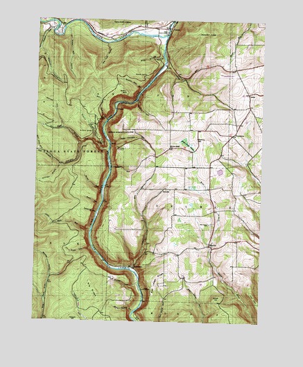
Tiadaghton, PA USGS Topographic Map
Click on map above to begin viewing in our Map Viewer.

This topographic map contains these locations and features:
Feature Name Type Latitude Longitude GNIS ID View Map
AnsoniaPopulated PlaceN41.7465°W77.4283°1202981View Map
Ansonia CemeteryCemeteryN41.7473°W77.4287°2770032View Map
Barbour RockSummitN41.7203°W77.4508°1168697View Map
Bartle - Middle Ridge CemeteryCemeteryN41.6806°W77.3916°2774800View Map
Bear RunStreamN41.7084°W77.4608°1168930View Map
Bee Tree HollowValleyN41.7402°W77.4613°1169093View Map
Beecher HollowValleyN41.6438°W77.4909°1169114View Map
Big RidgeRidgeN41.6376°W77.4675°1169555View Map
Bradley Wales Picnic AreaAreaN41.6331°W77.4472°1201584View Map
Browns LakeReservoirN41.6884°W77.3914°1195735View Map
Browns Lake DamDamN41.6884°W77.3914°1195736View Map
Burdic RunStreamN41.6795°W77.4630°1170701View Map
Campbells RunStreamN41.6467°W77.4461°1171140View Map
Cobble HillSummitN41.6351°W77.3983°1172094View Map
Colton PointCliffN41.7090°W77.4644°1172239View Map
Colton Point ParkParkN41.6998°W77.4647°1172240View Map
Darling RunStreamN41.7312°W77.4291°1172954View Map
Deadman HollowValleyN41.7378°W77.4984°1173027View Map
Deadman TrailTrailN41.7340°W77.4936°1205891View Map
DexterPopulated PlaceN41.7198°W77.3828°1203411View Map
Fourmile RunStreamN41.6965°W77.4597°1198067View Map
Good Spring HollowValleyN41.6294°W77.4448°1175806View Map
Grand Canyon of PennsylvaniaLocaleN41.7023°W77.4605°1212042View Map
Harrison LookoutLocaleN41.6973°W77.4536°1176586View Map
Herrington HollowValleyN41.7475°W77.4408°1176887View Map
Horse RunStreamN41.6734°W77.4636°1177446View Map
Ice Break RunStreamN41.6553°W77.4678°1177673View Map
KennedyPopulated PlaceN41.6801°W77.4283°1203928View Map
Kennedy CemeteryCemeteryN41.6799°W77.4355°2774820View Map
Left Branch Fourmile RunStreamN41.6992°W77.4747°1179137View Map
Left Steele Run TrailTrailN41.7278°W77.4680°1205889View Map
Leonard Harrison State ParkParkN41.6967°W77.4541°1198254View Map
Little Fourmile RunStreamN41.6987°W77.4586°1179549View Map
Little Slate RunStreamN41.6631°W77.4689°1179681View Map
Marsh CreekStreamN41.7434°W77.4278°1180448View Map
Matson SpringSpringN41.7274°W77.4414°1180549View Map
Middle Ridge ChurchChurchN41.6973°W77.4261°1181048View Map
Middle Ridge SwampSwampN41.6990°W77.4162°1181049View Map
Mount TomSummitN41.7451°W77.4072°1189631View Map
O'Connor BranchStreamN41.6895°W77.4866°1182724View Map
OlmsvillePopulated PlaceN41.6567°W77.4022°1204330View Map
Orchard SpringSpringN41.7037°W77.4696°1183024View Map
OwasseePopulated PlaceN41.7134°W77.4566°1204343View Map
Owassee Slide RunStreamN41.7212°W77.4419°1183146View Map
Painter RunStreamN41.7453°W77.4914°1183208View Map
Pinafore RunStreamN41.7167°W77.4450°1183752View Map
Pine Creek Gorge Natural AreaParkN41.6942°W77.4603°1212043View Map
Red Ledge RidgeRidgeN41.6392°W77.4336°1184762View Map
Refuge TrailTrailN41.6906°W77.4630°1205887View Map
Rexford BranchStreamN41.7001°W77.4686°1184958View Map
Rexford TrailTrailN41.7156°W77.4908°1184960View Map
Right Branch Fourmile RunStreamN41.6992°W77.4750°1185071View Map
Right Steele Run TrailTrailN41.7334°W77.4822°1205890View Map
Schanbacher TrailTrailN41.7487°W77.4697°1205875View Map
Semans TrailTrailN41.6851°W77.4725°1205886View Map
Sherman SchoolSchoolN41.7012°W77.4105°1187490View Map
Steele Run HollowValleyN41.7467°W77.4834°1188585View Map
Stowell RunStreamN41.6887°W77.4578°1188836View Map
Straight CreekStreamN41.6373°W77.4400°1188840View Map
Strap Mill HollowValleyN41.7347°W77.4304°1188855View Map
ThumptownPopulated PlaceN41.7028°W77.3911°1189559View Map
TiadaghtonPopulated PlaceN41.6473°W77.4455°1204812View Map
Trestle Hollow TrailTrailN41.6284°W77.4764°1205931View Map
Tumbling RunStreamN41.6698°W77.4655°1189915View Map
Wellsboro Johnston AirportAirportN41.7279°W77.3965°1194275View Map
West Branch CemeteryCemeteryN41.6656°W77.4030°1190894View Map
Wild Apple TrailTrailN41.7095°W77.4994°1191392View Map

Note: Coordinates in the location and feature list above are referenced to NAD83 datum.


Copyright (C) 2008-2024 Ryan Niemi / Sunset Dynamics ... All Rights Reserved