TopoQuest Logo
Do you find TopoQuest useful?
Help keep TopoQuest running and adding new maps/features by donating!
Bitcoin:  19c7KJd3qBynnjoSw5npx9KScwjBe4ifkT
Litecoin:  LXs6TkuXGGXo1vDsWCkWVdjQX94eUKd6ui
Home View Maps Find Maps Find Places Resources & Links


Temple Peak, Utah Topographic Map

USGS Map Title: Temple Peak, UT
USGS Map MRC: 41111G5
DRG (GeoTIFF) Download: o41111g5.tif


Neighboring USGS Topographic Map Quads:


  Naomi Peak, UT  
41111H6
 

  Tony Grove Creek, UT  
41111H5
 

  Garden City, UT  
41111H4
 

  Mount Elmer, UT  
41111G6
 

  Temple Peak, UT  
41111G5
 

  Meadowville, UT  
41111G4
 

  Logan Peak, UT  
41111F6
 

  Boulder Mountain, UT  
41111F5
 

  Red Spur Mountain, UT  
41111F4


Map MRC Location:

N42°
W112°
N42°
W111°
H8 H7 H6 H5 H4 H3 H2 H1
G8 G7 G6 G5 G4 G3 G2 G1
F8 F7 F6 F5 F4 F3 F2 F1
E8 E7 E6 E5 E4 E3 E2 E1
D8 D7 D6 D5 D4 D3 D2 D1
C8 C7 C6 C5 C4 C3 C2 C1
B8 B7 B6 B5 B4 B3 B2 B1
A8 A7 A6 A5 A4 A3 A2 A1
N41°
W112°
N41°
W111°

Temple Peak, UT USGS 1:24K Topographic Map Preview:
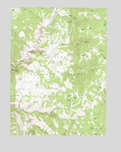
Temple Peak, UT USGS Topographic Map
Click on map above to begin viewing in our Map Viewer.

This topographic map contains these locations and features:
Feature Name Type Latitude Longitude GNIS ID View Map
Barrel SpringSpringN41.7870°W111.5335°1438405View Map
Bear HollowValleyN41.8519°W111.5863°1438479View Map
Blind HollowValleyN41.8327°W111.5997°1438909View Map
Borden ReservoirReservoirN41.7662°W111.5166°1439010View Map
Brachipad Summer Home AreaLocaleN41.8149°W111.6227°1450074View Map
Brachipad Summer Home AreaPopulated PlaceN41.8149°W111.6174°1450170View Map
Bubble SpringSpringN41.8726°W111.6207°1439212View Map
Chicken CreekStreamN41.8188°W111.6141°1439665View Map
Chicken Creek GuzzlerLakeN41.8070°W111.6157°1454702View Map
Conifer Box SpringSpringN41.8541°W111.5296°1439914View Map
Cottonwood CanyonValleyN41.8141°W111.6208°1440002View Map
Cottonwood Picnic AreaLocaleN41.8141°W111.6194°1440031View Map
Cottonwood SpringSpringN41.8672°W111.5501°1440042View Map
Cowley CanyonValleyN41.7769°W111.6197°1440099View Map
Elk SpringSpringN41.8331°W111.5096°1440913View Map
Ephraims GraveCemeteryN41.7637°W111.5436°1440948View Map
Ephraims SpringSpringN41.7525°W111.5420°1440949View Map
Hidden SpringSpringN41.8297°W111.5875°1441746View Map
Hunsaker CorralLocaleN41.7980°W111.5616°1441944View Map
Hunsaker SpringsSpringN41.7888°W111.5511°1441945View Map
Little Bear PondLakeN41.8723°W111.5221°1442664View Map
Little Cottonwood CreekStreamN41.7752°W111.6116°1442683View Map
Little Cottonwood SpringSpringN41.7892°W111.6144°1442685View Map
Little Ricks CanyonValleyN41.7552°W111.5991°1442773View Map
Little Rock SpringSpringN41.7867°W111.5396°1442776View Map
Lodge CampgroundLocaleN41.7785°W111.6219°1442831View Map
Lomia Girls CampLocaleN41.7752°W111.6183°1442867View Map
Long HollowValleyN41.7672°W111.5499°1442916View Map
Long Hollow SpringSpringN41.7840°W111.5477°1442922View Map
Maughan HollowValleyN41.7744°W111.6077°1443229View Map
Mud FlatFlatN41.7958°W111.5672°1443664View Map
Ricks CanyonValleyN41.7719°W111.6019°1444895View Map
Ricks SpringSpringN41.8402°W111.5886°1444897View Map
Sidehill SpringSpringN41.7515°W111.5126°1445572View Map
Snowbank SpringSpringN41.8548°W111.5245°1445751View Map
Spawn CreekStreamN41.8283°W111.5783°1445951View Map
Spawn Creek GuzzlerLakeN41.8401°W111.5748°1454908View Map
Steel HollowValleyN41.7608°W111.5980°1446120View Map
Temple Aspen SpringSpringN41.8421°W111.5291°1446381View Map
Temple ForkStreamN41.8335°W111.5922°1446386View Map
Temple PeakSummitN41.8283°W111.5344°1446387View Map
Temple SpringSpringN41.8143°W111.5201°1433221View Map
Theurer HollowValleyN41.8708°W111.5674°1446520View Map
Tin Cup SpringSpringN41.7969°W111.5068°1446616View Map
Trail HollowValleyN41.7663°W111.5574°1446683View Map
Trail Hollow SpringSpringN41.7508°W111.5531°1446684View Map
Trigaro SpringSpringN41.7570°W111.5175°1446718View Map
Twin Bridges Picnic AreaLocaleN41.8238°W111.6027°1446776View Map
Twin CreekStreamN41.8558°W111.5816°1446781View Map
Twin Creek CorralLocaleN41.8622°W111.5760°1450169View Map
West Hodges CreekStreamN41.8685°W111.5677°1447162View Map
Willis SinkBasinN41.8022°W111.5147°1447390View Map
Willow CreekStreamN41.7735°W111.5894°1447407View Map
Worm Fence SpringSpringN41.8609°W111.5508°1447533View Map

Note: Coordinates in the location and feature list above are referenced to NAD83 datum.


Copyright (C) 2008-2024 Ryan Niemi / Sunset Dynamics ... All Rights Reserved