TopoQuest Logo
Do you find TopoQuest useful?
Help keep TopoQuest running and adding new maps/features by donating!
Bitcoin:  19c7KJd3qBynnjoSw5npx9KScwjBe4ifkT
Litecoin:  LXs6TkuXGGXo1vDsWCkWVdjQX94eUKd6ui
Home View Maps Find Maps Find Places Resources & Links


Tattlersville, Alabama Topographic Map

USGS Map Title: Tattlersville, AL
USGS Map MRC: 31088F1
DRG (GeoTIFF) Download: o31088f1.tif


Neighboring USGS Topographic Map Quads:


  Coffeeville Lock And Dam, AL  
31088G2
 

  Coffeeville, AL  
31088G1
 

  McEntyre, AL  
31087G8
 

  Bladon Springs, AL  
31088F2
 

  Tattlersville, AL  
31088F1
 

  Winn, AL  
31087F8
 

  Bigbee, AL  
31088E2
 

  Saint Stephens, AL  
31088E1
 

  Jackson, AL  
31087E8


Map MRC Location:

N32°
W89°
N32°
W88°
H8 H7 H6 H5 H4 H3 H2 H1
G8 G7 G6 G5 G4 G3 G2 G1
F8 F7 F6 F5 F4 F3 F2 F1
E8 E7 E6 E5 E4 E3 E2 E1
D8 D7 D6 D5 D4 D3 D2 D1
C8 C7 C6 C5 C4 C3 C2 C1
B8 B7 B6 B5 B4 B3 B2 B1
A8 A7 A6 A5 A4 A3 A2 A1
N31°
W89°
N31°
W88°

Tattlersville, AL USGS 1:24K Topographic Map Preview:
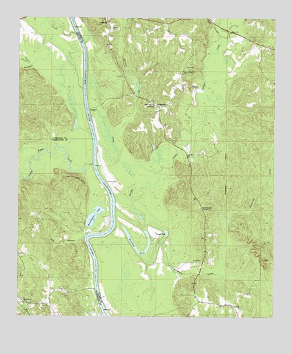
Tattlersville, AL USGS Topographic Map
Click on map above to begin viewing in our Map Viewer.

This topographic map contains these locations and features:
Feature Name Type Latitude Longitude GNIS ID View Map
Atkinson Landing (historical)LocaleN31.6293°W88.0847°138855View Map
Baileys LandingLocaleN31.6813°W88.0817°156014View Map
Bass Landing (historical)LocaleN31.7018°W88.0900°166103View Map
Blount CemeteryCemeteryN31.6371°W88.1028°114505View Map
Blount LandingLocaleN31.6363°W88.0872°156078View Map
Buena Vista Landing (historical)LocaleN31.6635°W88.0772°133771View Map
Cato Landing (historical)LocaleN31.6979°W88.0889°138871View Map
Chillitos Landing (historical)LocaleN31.7385°W88.0950°139978View Map
Christmas LandingLocaleN31.7115°W88.0906°156179View Map
Church of the Living GodChurchN31.7282°W88.0742°163599View Map
Clantons Landing (historical)LocaleN31.7493°W88.0978°133600View Map
Double Branch Assembly of God ChurchChurchN31.6315°W88.1220°117410View Map
Eberline Mill CreekStreamN31.6838°W88.0689°112848View Map
Frankville Landing (historical)LocaleN31.6463°W88.0878°138902View Map
Grace ChapelChurchN31.7296°W88.0433°164060View Map
Hatcheetigbee Landing (historical)LocaleN31.6593°W88.0906°138915View Map
Hatchetigbee HillsSummitN31.6821°W88.0964°119845View Map
Hatchetigbee LakeLakeN31.6668°W88.0880°119846View Map
Hatchetigbee Landing (historical)LocaleN31.6613°W88.0814°138916View Map
Hatchitigbee BarBarN31.6590°W88.0845°138917View Map
Hazard LandingLocaleN31.6802°W88.0839°138919View Map
Hazzards BarBarN31.6743°W88.0795°138920View Map
Hodges PondLakeN31.7202°W88.0390°120177View Map
Horrace Williams Landing (historical)LocaleN31.7390°W88.0925°133644View Map
Horseshoe LakeLakeN31.6535°W88.0671°120432View Map
J B Malones Landing (historical)LocaleN31.7263°W88.0908°133647View Map
Jordan CemeteryCemeteryN31.6996°W88.0358°121042View Map
Kanetuche ChurchChurchN31.6704°W88.0347°151936View Map
Kanetuche CreekStreamN31.6649°W88.0683°151937View Map
Mitchells ReserveReserveN31.6885°W88.0675°163611View Map
Mosley Springs ChurchChurchN31.7279°W88.0447°123109View Map
Nail BranchStreamN31.6579°W88.0917°123627View Map
New Hope CemeteryCemeteryN31.6507°W88.1239°157593View Map
New Hope United Methodist ChurchChurchN31.6504°W88.1245°152632View Map
New Union ChurchChurchN31.7418°W88.0814°163125View Map
Overstreet CemeteryCemeteryN31.6710°W88.0350°124331View Map
Rock BluffCliffN31.6549°W88.0908°138809View Map
Round PondLakeN31.6600°W88.0524°125982View Map
Saint Paul School (historical)SchoolN31.6488°W88.0339°133700View Map
Saint Pauls CemeteryCemeteryN31.6343°W88.0411°126182View Map
Saint Pauls ChurchChurchN31.6488°W88.0358°153288View Map
SalitpaPopulated PlaceN31.6296°W88.0200°153303View Map
Salitpa ChurchChurchN31.6304°W88.0228°133703View Map
Salitpa CreekStreamN31.6696°W88.0775°153343View Map
Sand BranchStreamN31.7415°W88.0264°126302View Map
Santa Bogue CreekStreamN31.6888°W88.0883°154492View Map
Scotts Woodyard Landing (historical)LocaleN31.7238°W88.0931°140118View Map
Sea Warrior CreekStreamN31.7307°W88.1200°153356View Map
Seyouyah CreekStreamN31.7432°W88.0972°153376View Map
Singletons Landing (historical)LocaleN31.7349°W88.0922°133709View Map
TattlersvillePopulated PlaceN31.7127°W88.0564°127713View Map
Thornton CemeteryCemeteryN31.7454°W88.0797°127929View Map
Union Chapel Methodist ChurchChurchN31.7138°W88.0597°164137View Map
Union Grove ChurchChurchN31.7135°W88.0589°128311View Map
Upper Bass Landing (historical)LocaleN31.7160°W88.0936°140150View Map
Watts Landing (historical)LocaleN31.6390°W88.0853°133729View Map

Note: Coordinates in the location and feature list above are referenced to NAD83 datum.


Copyright (C) 2008-2024 Ryan Niemi / Sunset Dynamics ... All Rights Reserved