TopoQuest Logo
Do you find TopoQuest useful?
Help keep TopoQuest running and adding new maps/features by donating!
Bitcoin:  19c7KJd3qBynnjoSw5npx9KScwjBe4ifkT
Litecoin:  LXs6TkuXGGXo1vDsWCkWVdjQX94eUKd6ui
Home View Maps Find Maps Find Places Resources & Links


Tahoe City, California Topographic Map

USGS Map Title: Tahoe City, CA
USGS Map MRC: 39120B2
DRG (GeoTIFF) Download: o39120b2.tif


Neighboring USGS Topographic Map Quads:


  Norden, CA  
39120C3
 

  Truckee, CA  
39120C2
 

  Martis Peak, CA  
39120C1
 

  Granite Chief, CA  
39120B3
 

  Tahoe City, CA  
39120B2
 

  Kings Beach, CA  
39120B1
 

  Wentworth Springs, CA  
39120A3
 

  Homewood, CA  
39120A2
 

  Meeks Bay, CA  
39120A1


Map MRC Location:

N40°
W121°
N40°
W120°
H8 H7 H6 H5 H4 H3 H2 H1
G8 G7 G6 G5 G4 G3 G2 G1
F8 F7 F6 F5 F4 F3 F2 F1
E8 E7 E6 E5 E4 E3 E2 E1
D8 D7 D6 D5 D4 D3 D2 D1
C8 C7 C6 C5 C4 C3 C2 C1
B8 B7 B6 B5 B4 B3 B2 B1
A8 A7 A6 A5 A4 A3 A2 A1
N39°
W121°
N39°
W120°

Tahoe City, CA USGS 1:24K Topographic Map Preview:
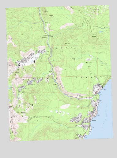
Tahoe City, CA USGS Topographic Map
Click on map above to begin viewing in our Map Viewer.

This topographic map contains these locations and features:
Feature Name Type Latitude Longitude GNIS ID View Map
Alpine MeadowsPopulated PlaceN39.1785°W120.2277°1701138View Map
Alpine MeadowsFlatN39.1735°W120.2321°218170View Map
Alpine Meadows Ski AreaLocaleN39.1574°W120.2391°1662378View Map
Antone MeadowsFlatN39.2010°W120.1530°218310View Map
Antone Meadows Natural PreserveReserveN39.2029°W120.1506°2741150View Map
Bear CreekStreamN39.1905°W120.1969°218809View Map
Bear Creek CampgroundLocaleN39.1827°W120.2077°218831View Map
Bear Trap CabinLocaleN39.2002°W120.1680°218882View Map
Big ChiefSummitN39.2410°W120.1963°219159View Map
BullsheadSummitN39.2346°W120.2013°1658168View Map
Burton Creek Natural PreserveReserveN39.1911°W120.1319°2741183View Map
Burton Creek State ParkParkN39.1949°W120.1427°1655281View Map
Comstock AcresPopulated PlaceN39.1591°W120.1496°1723340View Map
Deer CreekStreamN39.2221°W120.1994°222170View Map
Deer ParkParkN39.1821°W120.2155°1662425View Map
Deer Park Ski AreaLocaleN39.1866°W120.1991°1662423View Map
Fanny BridgeBridgeN39.1669°W120.1444°1723343View Map
Fir CragsPillarN39.1766°W120.1907°223515View Map
Five Lakes TrailheadLocaleN39.1794°W120.2299°274934View Map
Granlibakken Ski AreaLocaleN39.1549°W120.1563°1662421View Map
KT-22SummitN39.1830°W120.2410°226407View Map
Lake EstelleLakeN39.1637°W120.2500°223254View Map
Lake Tahoe DamDamN39.1669°W120.1438°1664623View Map
Little ChiefSummitN39.2452°W120.2024°227222View Map
Mount PlutoSummitN39.2416°W120.1396°230831View Map
Mount WatsonSummitN39.2202°W120.1471°237353View Map
North Tahoe Fire Protection District Station 51 North TahoeBuildingN39.1692°W120.1427°2622171View Map
North Tahoe Fire Protection District Station 56 Alpine MeadowsBuildingN39.1887°W120.1993°2622174View Map
Northstar-at-TahoeLocaleN39.2457°W120.1407°1723353View Map
Olympic Valley Post OfficePost OfficeN39.1997°W120.2286°2789123View Map
Page MeadowsFlatN39.1499°W120.1885°255007View Map
Painted RockSummitN39.2141°W120.1794°230238View Map
Pine LandPopulated PlaceN39.1366°W120.1585°1723354View Map
Pole CreekStreamN39.2369°W120.2063°234499View Map
Poulsen PeakSummitN39.2096°W120.2363°2071321View Map
Powder Bowl Ski AreaLocaleN39.1816°W120.2021°1662424View Map
RampartPopulated PlaceN39.1646°W120.1782°1659465View Map
Rideout Elementary SchoolSchoolN39.1296°W120.1655°1723355View Map
Sawtooth RidgeRidgeN39.2472°W120.1708°2784286View Map
Scott PeakSummitN39.1580°W120.2224°232731View Map
Silver CreekStreamN39.2249°W120.2010°233125View Map
Silver Creek CampgroundLocaleN39.2230°W120.2019°233133View Map
Silver PeakSummitN39.2202°W120.2460°233141View Map
Squaw CreekStreamN39.2116°W120.1985°235306View Map
Squaw ValleyValleyN39.2116°W120.1985°235324View Map
Squaw Valley Fire DepartmentBuildingN39.2053°W120.2057°2622331View Map
Squaw Valley State Reservation Area (historical)ParkN39.1921°W120.2324°235332View Map
SunnysidePopulated PlaceN39.1432°W120.1535°1659923View Map
Sunnyside-Tahoe City Census Designated PlaceCensusN39.1504°W120.1613°2410030View Map
Tahoe CityPopulated PlaceN39.1721°W120.1388°1659946View Map
Tahoe City Branch Auburn-Placer County LibraryBuildingN39.1732°W120.1388°1723467View Map
Tahoe City Golf CourseLocaleN39.1707°W120.1446°1723356View Map
Tahoe City Post OfficePost OfficeN39.1736°W120.1368°1723357View Map
Tahoe City Public BeachParkN39.1694°W120.1410°1723358View Map
Tahoe Lake Elementary SchoolSchoolN39.1736°W120.1422°235973View Map
Tahoe ParkParkN39.1405°W120.1535°1662420View Map
Tahoe ParkPopulated PlaceN39.1421°W120.1580°1723359View Map
Tahoe State Recreation AreaParkN39.1752°W120.1349°235976View Map
Tahoe TavernLocaleN39.1616°W120.1416°1662422View Map
Tahoe WoodsPopulated PlaceN39.1491°W120.1516°1723360View Map
TalmontPopulated PlaceN39.1449°W120.1669°1723361View Map
Thunder CliffCliffN39.1752°W120.1855°236330View Map
TimberlandPopulated PlaceN39.1274°W120.1657°1723473View Map
Twin CragsCliffN39.1666°W120.1660°236686View Map
Twin Peaks EstatesPopulated PlaceN39.1435°W120.1744°1723362View Map
Ward CreekStreamN39.1291°W120.1549°237226View Map
Ward Creek ProjectParkN39.1330°W120.1657°1723364View Map
Ward PeakSummitN39.1480°W120.2455°237232View Map
Watson LakeLakeN39.2247°W120.1377°237349View Map
Westshore Community CenterBuildingN39.1610°W120.1452°1723368View Map
William B Layton ParkParkN39.1666°W120.1435°1723369View Map
William Kent Guard Station and CampLocaleN39.1396°W120.1582°274931View Map

Note: Coordinates in the location and feature list above are referenced to NAD83 datum.


Copyright (C) 2008-2024 Ryan Niemi / Sunset Dynamics ... All Rights Reserved