TopoQuest Logo
Do you find TopoQuest useful?
Help keep TopoQuest running and adding new maps/features by donating!
Bitcoin:  19c7KJd3qBynnjoSw5npx9KScwjBe4ifkT
Litecoin:  LXs6TkuXGGXo1vDsWCkWVdjQX94eUKd6ui
Home View Maps Find Maps Find Places Resources & Links


Table Rock, South Carolina Topographic Map

USGS Map Title: Table Rock, SC
USGS Map MRC: 35082A6
DRG (GeoTIFF) Download: o35082a6.tif


Neighboring USGS Topographic Map Quads:


  Rosman, NC  
35082B7
 

  Brevard, NC  
35082B6
 

  Standingstone Mountain, SC  
35082B5
 

  Eastatoe Gap, NC  
35082A7
 

  Table Rock, SC  
35082A6
 

  Cleveland, SC  
35082A5
 

  Sunset, SC  
34082H7
 

  Pickens, SC  
34082H6
 

  Dacusville, SC  
34082H5


Map MRC Location:

N36°
W83°
N36°
W82°
H8 H7 H6 H5 H4 H3 H2 H1
G8 G7 G6 G5 G4 G3 G2 G1
F8 F7 F6 F5 F4 F3 F2 F1
E8 E7 E6 E5 E4 E3 E2 E1
D8 D7 D6 D5 D4 D3 D2 D1
C8 C7 C6 C5 C4 C3 C2 C1
B8 B7 B6 B5 B4 B3 B2 B1
A8 A7 A6 A5 A4 A3 A2 A1
N35°
W83°
N35°
W82°

Table Rock, SC USGS 1:24K Topographic Map Preview:
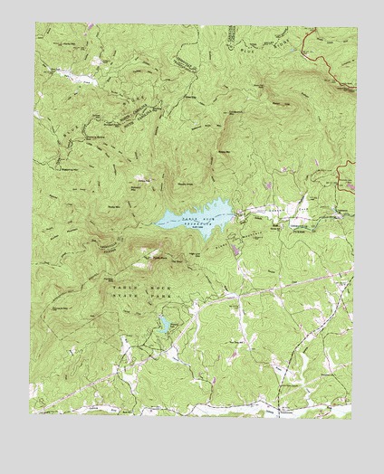
Table Rock, SC USGS Topographic Map
Click on map above to begin viewing in our Map Viewer.

This topographic map contains these locations and features:
Feature Name Type Latitude Longitude GNIS ID View Map
Adams CreekStreamN35.0007°W82.6446°1220133View Map
Battered Rock MountainSummitN35.0932°W82.6818°1231034View Map
Bensons Mill (historical)LocaleN35.0782°W82.6398°1245411View Map
Big BranchStreamN35.1087°W82.7199°981330View Map
Bigspring CreekStreamN35.0621°W82.7276°1220745View Map
Bigspring MountainSummitN35.0782°W82.7393°1231056View Map
Bradley CreekStreamN35.1085°W82.7360°1009575View Map
Brushy KnobSummitN35.0743°W82.6949°1231092View Map
Burgess CreekStreamN35.0107°W82.6435°1221134View Map
Burgess Creek Dam D-1945DamN35.0535°W82.6699°1239266View Map
Bursted Rock CreekStreamN35.1051°W82.7235°982308View Map
Bursted Rock MountainSummitN35.0929°W82.7162°1019433View Map
Buzzard MountainSummitN35.0726°W82.7124°1231114View Map
Caesars Head MountainSummitN35.1057°W82.6276°1245094View Map
Carrick CreekStreamN35.0015°W82.6804°1247173View Map
Cassell CemeteryCemeteryN35.1121°W82.7235°982734View Map
Chestnut CoveValleyN35.0661°W82.6975°1221557View Map
Cissom CreekStreamN35.0348°W82.6324°1221600View Map
Cold Mountain BranchStreamN35.1062°W82.7324°983351View Map
Coldbranch MountainSummitN35.0971°W82.6749°1247336View Map
Dolves MountainSummitN35.0943°W82.7257°1020003View Map
Douthels FordCrossingN35.0610°W82.6499°1251815View Map
Douthetts Cove School (historical)SchoolN35.0682°W82.6596°1245129View Map
Dowthit CoveValleyN35.0646°W82.6718°1222085View Map
East ForkPopulated PlaceN35.1096°W82.7421°1006189View Map
Flatrock CreekStreamN35.0615°W82.7085°1222448View Map
Galloway BranchStreamN35.0707°W82.6768°1222629View Map
Green CreekStreamN35.0332°W82.7015°1222869View Map
Grunting Spring GapGapN35.0882°W82.7296°986183View Map
Gum GapGapN35.1023°W82.6918°986217View Map
Hickory Flat CreekStreamN35.1135°W82.7118°986698View Map
High Low GapGapN35.0518°W82.6843°1223169View Map
Julian CreekStreamN35.1035°W82.6740°1223676View Map
Knob (historical)Populated PlaceN35.0040°W82.6812°1243411View Map
LakemontPopulated PlaceN35.0648°W82.6296°1246278View Map
Lance CemeteryCemeteryN35.0004°W82.7457°1223800View Map
Laurel CreekStreamN35.0590°W82.7149°1246302View Map
Lawton LakeReservoirN35.0743°W82.6582°1239780View Map
Lawton Lake Dam D-2825DamN35.0735°W82.6582°1239779View Map
LiberiaPopulated PlaceN35.0140°W82.6318°1243418View Map
Little Table Rock CreekStreamN35.0796°W82.7093°1224064View Map
Little Table Rock MountainSummitN35.0871°W82.7315°1021242View Map
Little Table Rock MountainSummitN35.0826°W82.7232°1231490View Map
Matthews CreekStreamN35.0626°W82.6501°1246560View Map
Methodist PondReservoirN35.0785°W82.6365°1239778View Map
Methodist Pond Dam D-0044DamN35.0785°W82.6365°1239777View Map
Miracle Hill SchoolSchoolN35.0026°W82.6329°1243446View Map
New Hope Baptist ChurchChurchN35.0107°W82.6526°1249834View Map
New Town SchoolSchoolN35.0243°W82.6665°1225027View Map
Panther GapGapN35.0435°W82.7179°1225287View Map
Pine Shore LakesReservoirN35.1238°W82.7284°1008634View Map
Piney MountainSummitN35.0532°W82.6782°1231665View Map
Pinnacle LakeReservoirN35.0290°W82.6976°1225506View Map
Pinnacle LakeReservoirN35.0851°W82.6915°1238581View Map
Pinnacle MountainSummitN35.0337°W82.7415°1225507View Map
PumpkintownPopulated PlaceN35.0029°W82.6529°1250271View Map
Pumpkintown Fire DepartmentBuildingN35.0160°W82.6504°2578473View Map
Raven CliffCliffN35.0998°W82.6540°1225764View Map
Raven Cliff FallsFallsN35.1057°W82.6610°1225765View Map
Reeds RunStreamN35.0171°W82.6882°2057029View Map
Reedy MountainSummitN35.0846°W82.6787°1231715View Map
River Falls Fire Department Bald Rock Highway 276BuildingN35.0812°W82.6298°2578665View Map
Rock Laurel BranchStreamN35.0704°W82.7246°1225944View Map
Rock SchoolSchoolN35.0010°W82.7099°1225946View Map
Rocky MountainSummitN35.1182°W82.7390°993608View Map
Rocky MountainSummitN35.0676°W82.7210°1231741View Map
Saluda Hill CemeteryCemeteryN35.0618°W82.6526°1244829View Map
Saluda Hill ChurchChurchN35.0612°W82.6526°1250739View Map
Slicking CreekStreamN35.0651°W82.6976°1226675View Map
Slicking FallsFallsN35.0751°W82.7040°1250929View Map
Slicking GapGapN35.0985°W82.7046°994915View Map
Slicking MountainSummitN35.0929°W82.6968°1231804View Map
Soapstone ChurchChurchN35.0143°W82.6315°1250948View Map
Soapstone School (historical)SchoolN35.0143°W82.6315°1243548View Map
South Carolina Noname 23026 DamDamN35.0646°W82.6715°1237512View Map
South Carolina Noname 39006 D-1946 DamDamN35.0851°W82.6915°1238580View Map
Sunfish CreekStreamN35.0623°W82.7307°1226963View Map
Sunfish MountainSummitN35.0554°W82.7446°1231846View Map
Table RockSummitN35.0507°W82.7035°1227019View Map
Table Rock BridgeBridgeN35.0635°W82.6501°1245349View Map
Table Rock CoveReservoirN35.0635°W82.6715°1237513View Map
Table Rock ReservoirReservoirN35.0634°W82.6846°1251107View Map
Table Rock State ParkParkN35.0371°W82.7074°1227020View Map
Table Rock State Park Historic DistrictParkN35.0390°W82.7054°1243561View Map
The StoolSummitN35.0504°W82.6937°1231860View Map
Turkey MountainSummitN35.1087°W82.7118°1023009View Map
Weaver CreekStreamN35.0037°W82.6396°1227450View Map

Note: Coordinates in the location and feature list above are referenced to NAD83 datum.


Copyright (C) 2008-2024 Ryan Niemi / Sunset Dynamics ... All Rights Reserved