TopoQuest Logo
Do you find TopoQuest useful?
Help keep TopoQuest running and adding new maps/features by donating!
Bitcoin:  19c7KJd3qBynnjoSw5npx9KScwjBe4ifkT
Litecoin:  LXs6TkuXGGXo1vDsWCkWVdjQX94eUKd6ui
Home View Maps Find Maps Find Places Resources & Links


Sunrise Beach, Missouri Topographic Map

USGS Map Title: Sunrise Beach, MO
USGS Map MRC: 38092B7
DRG (GeoTIFF) Download: o38092b7.tif


Neighboring USGS Topographic Map Quads:


  Proctor Creek, MO  
38092C8
 

  Gravois Mills, MO  
38092C7
 

  Rocky Mount, MO  
38092C6
 

  Bollinger Creek, MO  
38092B8
 

  Sunrise Beach, MO  
38092B7
 

  Lake Ozark, MO  
38092B6
 

  Barnumton, MO  
38092A8
 

  Green Bay Terrace, MO  
38092A7
 

  Camdenton, MO  
38092A6


Map MRC Location:

N39°
W93°
N39°
W92°
H8 H7 H6 H5 H4 H3 H2 H1
G8 G7 G6 G5 G4 G3 G2 G1
F8 F7 F6 F5 F4 F3 F2 F1
E8 E7 E6 E5 E4 E3 E2 E1
D8 D7 D6 D5 D4 D3 D2 D1
C8 C7 C6 C5 C4 C3 C2 C1
B8 B7 B6 B5 B4 B3 B2 B1
A8 A7 A6 A5 A4 A3 A2 A1
N38°
W93°
N38°
W92°

Sunrise Beach, MO USGS 1:24K Topographic Map Preview:
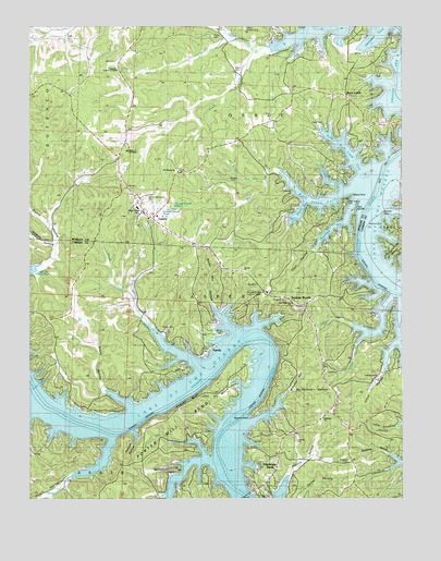
Sunrise Beach, MO USGS Topographic Map
Click on map above to begin viewing in our Map Viewer.

This topographic map contains these locations and features:
Feature Name Type Latitude Longitude GNIS ID View Map
Alcorn HollowValleyN38.1300°W92.8624°713190View Map
Bar-Vik AirportAirportN38.1754°W92.8593°2679351View Map
Bond CemeteryCemeteryN38.2386°W92.8063°742876View Map
Bond School (historical)SchoolN38.2445°W92.8155°745321View Map
Brush CreekStreamN38.1713°W92.8355°714827View Map
Buck CreekPopulated PlaceN38.2314°W92.7685°738539View Map
Buck CreekStreamN38.2120°W92.7941°714954View Map
Buck Creek CoveBayN38.2031°W92.7769°738388View Map
Buck Creek School (historical)SchoolN38.2314°W92.7680°745322View Map
Buckley CemeteryCemeteryN38.2089°W92.8077°742874View Map
Camp BranchStreamN38.1714°W92.7677°715244View Map
Cape Galena (historical)Populated PlaceN38.2059°W92.7674°755637View Map
Cape Galena CemeteryCemeteryN38.2031°W92.7693°742875View Map
Cape HollowValleyN38.2017°W92.7674°715380View Map
City of LaurieCivilN38.2080°W92.8254°2398400View Map
Corcyra (historical)LocaleN38.2092°W92.7885°744796View Map
Cozy CoveBayN38.1567°W92.8702°716438View Map
Deicel HollowValleyN38.1256°W92.7841°716821View Map
Dry BranchStreamN38.1396°W92.8237°717066View Map
Easter Hollow CoveBayN38.2086°W92.7738°738390View Map
Evansview Church of ChristChurchN38.2384°W92.8455°742878View Map
Folsom BluffCliffN38.1509°W92.8227°718053View Map
Galena PointCapeN38.2050°W92.7677°718314View Map
Garber Memorial CemeteryCemeteryN38.2039°W92.8357°742873View Map
Gravois Fire Protection District Station 5BuildingN38.2012°W92.8309°2620686View Map
Gravois Fire Protection District Station 5BuildingN38.2012°W92.8309°2621226View Map
Gravois Fire Protection District Station 7BuildingN38.2315°W92.7700°2620688View Map
Gravois Mills Post OfficePost OfficeN38.2105°W92.8440°2782874View Map
Hurricane DeckPopulated PlaceN38.1317°W92.7938°720040View Map
Hurricane Deck Lookout TowerTowerN38.1781°W92.7960°755224View Map
Jenkins HollowValleyN38.1917°W92.8671°720296View Map
John Hill HollowValleyN38.1550°W92.8085°720339View Map
Kent Memorial ChurchChurchN38.1767°W92.7871°742870View Map
Kinchlow HollowValleyN38.1350°W92.7516°720594View Map
Lakeland ChurchChurchN38.1464°W92.7769°742869View Map
LauriePopulated PlaceN38.1992°W92.8335°738538View Map
Laurie Police DepartmentBuildingN38.1963°W92.8312°2752258View Map
Little Kinchlow HollowValleyN38.1439°W92.7521°721260View Map
Lynch HollowValleyN38.1661°W92.7524°721697View Map
McFarland HollowValleyN38.1534°W92.7880°722103View Map
Mill CreekStreamN38.2436°W92.8005°722333View Map
Mistwood AirportAirportN38.1331°W92.8299°758618View Map
Moonlight BayBayN38.1956°W92.7746°738386View Map
Mount Sinai School (historical)SchoolN38.1720°W92.8682°745253View Map
North Buck Creek CoveBayN38.2173°W92.7688°738391View Map
North Fork Buck CreekStreamN38.2100°W92.7969°723454View Map
Oak Hill School (historical)SchoolN38.1325°W92.7652°745255View Map
Ozark ChapelChurchN38.2009°W92.8382°742872View Map
Porter Mill BendBendN38.1459°W92.8238°724765View Map
Porter Mill HollowValleyN38.1770°W92.8152°724766View Map
Possum HollowValleyN38.1428°W92.8405°724773View Map
PurvisPopulated PlaceN38.1639°W92.8174°725009View Map
Rockdale CemeteryCemeteryN38.1350°W92.7680°742868View Map
Rockdale ChurchChurchN38.1350°W92.7674°725476View Map
Sagamo PointCapeN38.1467°W92.8016°725712View Map
Saint Patrick CemeteryCemeteryN38.2118°W92.8257°2702573View Map
Saint Patricks ChurchChurchN38.2120°W92.8269°725859View Map
Shrine of Saint PatrickChurchN38.2173°W92.8424°742877View Map
Silvey CemeteryCemeteryN38.2475°W92.8155°726460View Map
South Fork Mill CreekStreamN38.2436°W92.8005°726746View Map
Spring CoveStreamN38.1661°W92.7652°726896View Map
Staley HollowValleyN38.1500°W92.8421°726992View Map
Stevens CemeteryCemeteryN38.1978°W92.7566°727085View Map
Stevens PointCapeN38.1995°W92.7560°727086View Map
Still Water BayBayN38.2011°W92.7849°738387View Map
Sugartree HollowValleyN38.1250°W92.8685°727265View Map
Sunrise BeachPopulated PlaceN38.1759°W92.7844°727318View Map
Sunrise Beach Fire DepartmentBuildingN38.1533°W92.8114°2621079View Map
Sunrise Beach Fire Department Station 1BuildingN38.1790°W92.7962°2620407View Map
Sunrise Beach Fire Department Station 2 HeadquartersBuildingN38.1450°W92.7643°2621705View Map
Sunrise Beach Police DepartmentBuildingN38.1758°W92.7846°2752567View Map
Sunrise Beach Post OfficePost OfficeN38.1544°W92.7727°2782858View Map
Sunrise ChurchChurchN38.1856°W92.8035°742871View Map
Township of JasperCivilN38.1580°W92.7863°766391View Map
Twin IslandsIslandN38.2020°W92.7655°738389View Map
Village of Sunrise BeachCivilN38.1675°W92.7793°2399935View Map
Welcher HollowValleyN38.1539°W92.7888°728488View Map
White Hall School (historical)SchoolN38.1770°W92.8196°745254View Map

Note: Coordinates in the location and feature list above are referenced to NAD83 datum.


Copyright (C) 2008-2024 Ryan Niemi / Sunset Dynamics ... All Rights Reserved